
Articles | Volume 12, issue 2
https://doi.org/10.5194/soil-12-1213-2026
© Author(s) 2026. This work is distributed under
the Creative Commons Attribution 4.0 License.
the Creative Commons Attribution 4.0 License.
https://doi.org/10.5194/soil-12-1213-2026
© Author(s) 2026. This work is distributed under
the Creative Commons Attribution 4.0 License.
the Creative Commons Attribution 4.0 License.
Original research article
| 
19 Nov 2026
Original research article |
| 19 Nov 2026
| 19 Nov 2026
Use of spatial embeddings in genosoil identification
Julio César Pachón Maldonado
CORRESPONDING AUTHOR

Sydney Institute of Agriculture and School of Life and Environmental Sciences, The University of Sydney, Eveleigh, NSW 2015, Australia
José Padarian
Sydney Institute of Agriculture and School of Life and Environmental Sciences, The University of Sydney, Eveleigh, NSW 2015, Australia
Quentin Styc
Sydney Institute of Agriculture and School of Life and Environmental Sciences, The University of Sydney, Eveleigh, NSW 2015, Australia
Alex B. McBratney
Sydney Institute of Agriculture and School of Life and Environmental Sciences, The University of Sydney, Eveleigh, NSW 2015, Australia
Related authors
Lena Wang, Sharon A. Billings, Li Li, Daniel R. Hirmas, Keira Johnson, Devon Kerins, Julio Pachon, Curtis Beutler, Karla M. Jarecke, Vaishnavi Varikuti, Micah Unruh, Hoori Ajami, Holly Barnard, Alejandro N. Flores, Kenneth Williams, and Pamela L. Sullivan
Biogeosciences, 22, 6097–6117, https://doi.org/10.5194/bg-22-6097-2025, https://doi.org/10.5194/bg-22-6097-2025, 2025
Short summary
Short summary
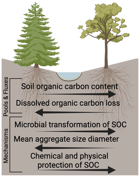
Our study looked at how different forest types and conditions affected soil microbes and soil carbon and stability. Aspen organic matter led to higher microbial activity, smaller soil aggregates, and more stable soil carbon, possibly reducing dissolved organic carbon movement from hillslopes to streams. This shows the importance of models like the Microbial Efficiency – Matrix Stabilization framework for predicting CO2 release, soil carbon stability, and carbon movement.
Yin-Chung Huang, José Padarian, Budiman Minasny, and Alex B. McBratney
SOIL, 11, 553–563, https://doi.org/10.5194/soil-11-553-2025, https://doi.org/10.5194/soil-11-553-2025, 2025
Short summary
Short summary
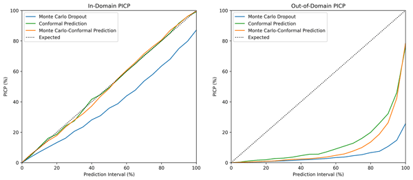
Uncertainty quantification plays a crucial role in reporting machine learning models in soil spectroscopy. This study introduces Monte Carlo conformal prediction (MC-CP), a novel method for uncertainty quantification in deep-learning soil spectral models. MC-CP outperformed two established methods, providing the most reliable results. Its efficiency and robustness make it a practical choice for implementing soil spectral models in decision making.
Marliana Tri Widyastuti, José Padarian, Budiman Minasny, Mathew Webb, Muh Taufik, and Darren Kidd
SOIL, 11, 287–307, https://doi.org/10.5194/soil-11-287-2025, https://doi.org/10.5194/soil-11-287-2025, 2025
Short summary
Short summary
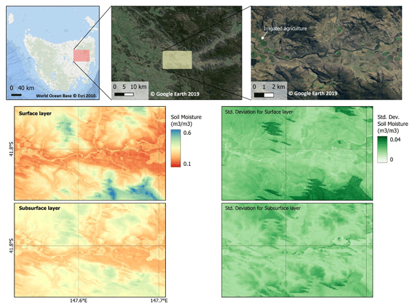
This work aims to predict soil water content at a fine spatiotemporal resolution (80 m grids, daily) to support agricultural management in Tasmania. It proves that transfer learning can improve the accuracy of deep learning models to predict multilevel soil moisture. We address the challenge of mapping soil moisture at field-scale resolution and integrate the model into a near-real-time monitoring system.
Marliana Tri Widyastuti, Budiman Minasny, José Padarian, Federico Maggi, Matt Aitkenhead, Amélie Beucher, John Connolly, Dian Fiantis, Darren Kidd, Yuxin Ma, Fraser Macfarlane, Ciaran Robb, Rudiyanto, Budi Indra Setiawan, and Muh Taufik
Earth Syst. Sci. Data Discuss., https://doi.org/10.5194/essd-2024-333, https://doi.org/10.5194/essd-2024-333, 2024
Preprint withdrawn
Short summary
Short summary
PEATGRIDS, the first dataset containing maps of global peat thickness and carbon stock at 1 km resolution. The dataset has been publicly available at Zenodo to support further analyses and modelling of peatlands across the globe. This work employed the random forest machine learning model to provide spatially explicit peat carbon stock at pixel basis.
Wartini Ng, Budiman Minasny, Alex McBratney, Patrice de Caritat, and John Wilford
Earth Syst. Sci. Data, 15, 2465–2482, https://doi.org/10.5194/essd-15-2465-2023, https://doi.org/10.5194/essd-15-2465-2023, 2023
Short summary
Short summary
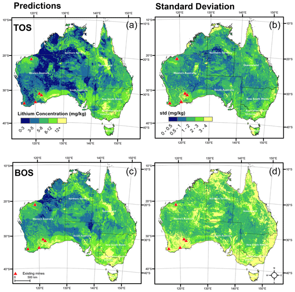
With a higher demand for lithium (Li), a better understanding of its concentration and spatial distribution is important to delineate potential anomalous areas. This study uses a framework that combines data from recent geochemical surveys and relevant environmental factors to predict and map Li content across Australia. The map shows high Li concentration around existing mines and other potentially anomalous Li areas. The same mapping principles can potentially be applied to other elements.
Mercedes Román Dobarco, Alexandre M. J-C. Wadoux, Brendan Malone, Budiman Minasny, Alex B. McBratney, and Ross Searle
Biogeosciences, 20, 1559–1586, https://doi.org/10.5194/bg-20-1559-2023, https://doi.org/10.5194/bg-20-1559-2023, 2023
Short summary
Short summary
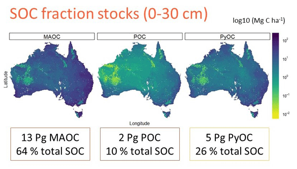
Soil organic carbon (SOC) is of a heterogeneous nature and varies in chemistry, stabilisation mechanisms, and persistence in soil. In this study we mapped the stocks of SOC fractions with different characteristics and turnover rates (presumably PyOC >= MAOC > POC) across Australia, combining spectroscopy and digital soil mapping. The SOC stocks (0–30 cm) were estimated as 13 Pg MAOC, 2 Pg POC, and 5 Pg PyOC.
Cited articles
Amundson, R., Guo, Y., and Gong, P.: Soil Diversity and Land Use in the United States, Ecosystems, 6, 470–482, https://doi.org/10.1007/s10021-002-0160-2, 2003.
Bockheim, J. G.: Soil endemism and its relation to soil formation theory, Geoderma, 129, 109–124, https://doi.org/10.1016/j.geoderma.2004.12.044, 2005.
Brown, C. F., Kazmierski, M. R., Pasquarella, V. J., Rucklidge, W. J., Samsikova, M., Zhang, C., Shelhamer, E., Lahera, E., Wiles, O., Ilyushchenko, S., Gorelick, N., Zhang, L. L., Alj, S., Schechter, E., Askay, S., Guinan, O., Moore, R., Boukouvalas, A., and Kohli, P.: AlphaEarth Foundations: An embedding field model for accurate and efficient global mapping from sparse label data, arXiv [preprint], arXiv:2507.22291, https://doi.org/10.48550/arXiv.2507.22291, 2025.
Dazzi, C. and Papa, G. L.: Soil genetic erosion: New conceptual developments in soil security, Int. Soil Water Conserv. Res., 7, 317–324, https://doi.org/10.1016/j.iswcr.2019.08.001, 2019.
Dror, I., Yaron, B., and Berkowitz, B.: The human impact on all soil-forming factors during the anthropocene, ACS Environ. Au, 2, 11–19, https://doi.org/10.1021/acsenvironau.1c00010, 2021.
Evangelista, S. J., Field, D. J., McBratney, A. B., Minasny, B., Ng, W., Padarian, J., Román Dobarco, M., and Wadoux, A. M. J.-C.: A proposal for the assessment of soil security: Soil functions, soil services and threats to soil, Soil Security, 10, 100086, https://doi.org/10.1016/j.soisec.2023.100086, 2023.
Feng, Z., Atzberger, C., Jaffer, S., Knezevic, J., Sormunen, S., Young, R., Lisaius, M. C., Immitzer, M., Jackson, T., Ball, J., Coomes, D. A., Madhavapeddy, A., Blake, A., and Keshav, S.: TESSERA: Temporal Embeddings of Surface Spectra for Earth Representation and Analysis, arXiv [preprint], arXiv:2506.20380, https://doi.org/10.48550/arXiv.2506.20380, 2025.
Francos, N., Jayasekara, T., Ng, W., Sharififar, A., Styc, Q., Watt, D. J., and McBratney, A.: Delineating Genosoils and Phenosoils in Europe Using the Global Pedogenon Map, Eur. J. Soil Sci., 76, e70249, https://doi.org/10.1111/ejss.70249, 2025a.
Francos, N., Sharififar, A., Flynn, T., Styc, Q., Evangelista, S. J., Padarian, J., Ng, W., Field, D. J., Minasny, B., and McBratney, A. B.: The global pedogenon map: Combining and spatialising the factors of soil formation, Geoderma, 460, 117462, https://doi.org/10.1016/j.geoderma.2025.117462, 2025b.
Francos, N., Sharififar, A., Flynn, T., Styc, Q., Evangelista, S. J., Padarian, J., Ng, W., Field, D., Minasny, B., and McBratney, A.: The Global Pedogenon Map: Combining and Spatialising the Factors of Soil Formation, Zenodo [data set], https://doi.org/10.5281/zenodo.15678953, 2025c.
Hengl, T., Mendes de Jesus, J., Heuvelink, G. B. M., Ruiperez Gonzalez, M., Kilibarda, M., Blagotić, A., Shangguan, W., Wright, M. N., Geng, X., Bauer-Marschallinger, B., Guevara, M. A., Vargas, R., MacMillan, R. A., Batjes, N. H., Leenaars, J. G. B., Ribeiro, E., Wheeler, I., Mantel, S., and Kempen, B.: SoilGrids250m: Global gridded soil information based on machine learning, PLOS ONE, 12, e0169748, https://doi.org/10.1371/journal.pone.0169748, 2017.
Huggett, R. J.: Soil as a System, in: Hydrogeology, Chemical Weathering, and Soil Formation, edited by: Hunt, A., Egli, M., and Faybishenko, B., Wiley, Hoboken, NJ, 1–20, https://doi.org/10.1002/9781119563952.ch1, 2021.
Ibáñez, J. J., Krasilnikov, P. V., and Saldaña, A.: Archive and refugia of soil organisms: applying a pedodiversity framework for the conservation of biological and non-biological heritages, J. Appl. Ecol., 49, 1267–1277, https://doi.org/10.1111/j.1365-2664.2012.02213.x, 2012.
Jang, H. J., Dobarco, M. R., Minasny, B., Campusano, J. P., and McBratney, A.: Assessing human impacts on soil organic carbon change in the Lower Namoi Valley, Australia, Anthropocene, 43, 100393, https://doi.org/10.1016/j.ancene.2023.100393, 2023.
Minasny, B., McBratney, A. B., and Hartemink, A. E.: Global pedodiversity, taxonomic distance, and the World Reference Base, Geoderma, 155, 132–139, https://doi.org/10.1016/j.geoderma.2009.04.024, 2010.
Pachón Maldonado, J. C., Padarian, J., Styc, Q., and McBratney, A.: Use of Spatial Embeddings in Genosoil Identification: analysis code and UK candidate genosoil maps, Zenodo [code and data set], https://doi.org/10.5281/zenodo.19424156, 2026.
Rahman, M.: Physically Interpretable AlphaEarth Foundation Model Embeddings Enable LLM-Based Land Surface Intelligence, arXiv [preprint], arXiv:2602.10354, https://doi.org/10.48550/arXiv.2602.10354, 2026.
Richter, D. de B.: Humanity's transformation of Earth's soil: Pedology's new frontier, Soil Sci., 172, 957–967, https://doi.org/10.1097/ss.0b013e3181586bb7, 2007.
Richter, D. de B. and Yaalon, D. H.: “The changing model of soil” revisited, Soil Sci. Soc. Am. J., 76, 766–778, https://doi.org/10.2136/sssaj2011.0407, 2012.
Richter, D. de B., Eppes, M. C., Austin, J. C., Bacon, A. R., Billings, S. A., Brecheisen, Z., Ferguson, T. A., Markewitz, D., Pachon, J., Schroeder, P. A., and Wade, A. M.: Soil production and the soil geomorphology legacy of Grove Karl Gilbert, Soil Sci. Soc. Am. J., 84, 1–20, https://doi.org/10.1002/saj2.20030, 2020.
Román Dobarco, M., McBratney, A., Minasny, B., and Malone, B.: A modelling framework for pedogenon mapping, Geoderma, 393, 115012, https://doi.org/10.1016/j.geoderma.2021.115012, 2021a.
Román Dobarco, M., McBratney, A., Minasny, B., and Malone, B.: A framework to assess changes in soil condition and capability over large areas, Soil Secur., 4, 100011, https://doi.org/10.1016/j.soisec.2021.100011, 2021b.
Román Dobarco, M., Padarian Campusano, J., McBratney, A. B., Malone, B., and Minasny, B.: Genosoil and phenosoil mapping in continental Australia is essential for soil security, Soil Secur., 13, 100108, https://doi.org/10.1016/j.soisec.2023.100108, 2023.
Rousseeuw, P. J.: Silhouettes: a graphical aid to the interpretation and validation of cluster analysis, J. Comput. Appl. Math., 20, 53–65, https://doi.org/10.1016/0377-0427(87)90125-7, 1987.
Soil Survey Staff: Gridded Soil Survey Geographic (gSSURGO) Database for the Conterminous United States, FY2026 release, United States Department of Agriculture, Natural Resources Conservation Service [data set], https://nrcs.app.box.com/v/soils (last access: 8 September 2026), 2026.
Styc, Q., Minasny, B., Jang, H. J., and McBratney, A.: Modelling soil organic carbon dynamics at the continental extent using pedogenon mapping, Eur. J. Soil Sci., 76, e70070, https://doi.org/10.1111/ejss.70070, 2025.
Theobald, D. M., Kennedy, C., Chen, B., Oakleaf, J., Baruch-Mordo, S., and Kiesecker, J.: Earth transformed: detailed mapping of global human modification from 1990 to 2017, Earth Syst. Sci. Data, 12, 1953–1972, https://doi.org/10.5194/essd-12-1953-2020, 2020.
Theobald, D. M., Oakleaf, J. R., Moncrieff, G., Voigt, M., Kiesecker, J., and Kennedy, C. M.: Global extent and change in human modification of terrestrial ecosystems from 1990 to 2022, Sci. Data, 12, 606, https://doi.org/10.1038/s41597-025-04892-2, 2025.
Short summary
Identifying local soil references for research in heavily modified landscapes is challenging. We evaluated whether AI satellite models at 10 m resolution to classify potentially undisturbed soils and apply the findings internationally. Pixels with less human disturbance aligned better with undisturbed references. Results indicate AI models may help find candidate reference soils where local examples are scarce.
Identifying local soil references for research in heavily modified landscapes is challenging. We...


Altmetrics
Final-revised paper
Preprint