the Creative Commons Attribution 4.0 License.
the Creative Commons Attribution 4.0 License.
 | 09 Sep 2025
Research at the interface between Indigenous knowledge and soil science; weaving knowledges to understand horticultural land use in Aotearoa / New Zealand
Julie Gillespie
Matiu Payne
Dione Payne
Sarah Edwards
Dyanna Jolly
Carol Smith
Jo-Anne Cavanagh
Addressing the complex challenges of soil and food security at international and local scales requires moving beyond the boundaries of individual disciplines and knowledge systems. The value of transdisciplinary research approaches is increasingly recognised, including those that value and incorporate Indigenous knowledge systems and holders. Using a case study at Pōhatu, Aotearoa / New Zealand, this paper demonstrates the value of a transdisciplinary approach to explore past Māori food landscapes and contribute to contemporary Māori soil health and food sovereignty aspirations. Engaging at the interface between soil science and Indigenous knowledge (mātauraka Māori) in an Aotearoa / New Zealand context, we provide an example and guide for weaving knowledges in a transdisciplinary context. Here, mātauraka Māori, including waiata (songs) and ingoa wāhi (place names), provided the map of where to look and why, and soil analysis yielded insight into past cultivation, soil modification, and fertilisation practices. Both knowledges were needed to interpret the findings and support Māori in re-establishing traditional horticultural practices. Furthermore, the paper extends the current literature on the numerous conceptual frameworks developed to support and guide transdisciplinary research by providing an example of how to do this type of research in an on-the-ground application.
- Article
(10057 KB) - Full-text XML
- BibTeX
- EndNote


To address the complex challenges of soil and food security at international and local scales, there is a need for research that moves beyond the boundaries of individual disciplines and knowledge systems (Bouma, 2015; Bouma and McBratney, 2013; Cheik and Jouquet, 2020; Keesstra et al., 2016). Consequently, there is increasing attention to transdisciplinary research (TDR) approaches, including those that value and incorporate Indigenous knowledge systems and holders (Anthony, 2017; Chakraborty et al., 2022; Kassam, 2021; Ramaswami et al., 2022; Robson-Williams et al., 2023; Smith et al., 2016). Achieving this requires challenging us, the soil science community, to see value in considering other knowledge to address these complex global challenges. There is, nevertheless, a lack of empirical research that demonstrates how to connect these different knowledges within a TDR approach, particularly in relation to soils (see Gillespie et al., 2024, for discussion). To address this gap, this paper weaves together soil science and Indigenous knowledge in a TDR framework to understand food-producing landscapes in Aotearoa / New Zealand. In doing so, we will provide broader methodological learning to inform and guide soil scientists in their engagement with TDR approaches to address the needs and challenges pertaining to sustainable soil and food futures.
Soil science is recognised as naturally interdisciplinary, at the intersection of the atmosphere, biosphere, hydrosphere and lithosphere, involving a range of Western science disciplines, and, at times, aspects of the arts (Brevik et al., 2015). However, recognising the limitations of Western science disciplines and the opportunities that engaging with other ways of knowing such as Indigenous knowledge provide (Black and Tylianakis, 2024; Stein et al., 2024), we argue that the holistic focus of interdisciplinary research can be extended further through TDR when addressing complex global challenges. Importantly, it is the interface between society and soil that drives the shift from interdisciplinary to transdisciplinary approaches, which can be summarised as transitioning from science for society to science with society (Scholz, 2011). This is not to reject the need for interdisciplinary research in soil science or the narrow-focused disciplinary studies that are essential for producing knowledge of soil functions and processes (Brevik et al., 2015; Gibbons et al., 1994). Instead, TDR brings together academic disciplines, non-academic stakeholders, and other knowledges, including Indigenous knowledge, to provide ways to understand and address these complex issues that sit beyond the capabilities of a single academic discipline (Bennich et al., 2020; Bouma, 2010; Huynh et al., 2022; Kamelarczyk and Smith-Hall, 2014; Pohl and Hirsch Hadorn, 2008; Stein et al., 2024). As such, a transdisciplinary approach resonates with recent ethnopedology research that recognises the perspectives that different knowledge holders and researchers have through a focus on both etics and emics (da Silva et al., 2024; Morales et al., 2023; Mostowlansky and Rota, 2020). Drawing on anthropology and linguistics, an etic perspective is defined as the viewpoint of an outsider, such as a scientist working with people and knowledge from an Indigenous culture they are not part of, while an emic perspective reflects the viewpoint of insiders, such as Indigenous knowledge holders (Morales et al., 2023). There is thus a focus on the complementary and additive nature of the knowledges, which is also needed in a transdisciplinary approach.
While there is no universally accepted definition of TDR, along with rules and guiding standards for conducting research in this manner, there are several key themes that emerge from the literature:
-
Beneficial when solving complex, real-world problems encountered by society (Hirsch Hadorn et al., 2008; Lang et al., 2012; Scholz, 2011; Scholz et al., 2006).
-
Seeks to generate knowledge by addressing real-world problems and identifying socially robust solutions applicable in both scientific and societal contexts (Bennich et al., 2020; Gibbons et al., 1994; Knapp et al., 2019; Lang et al., 2012; Scholz, 2011; Scholz et al., 2006).
-
Creates mutual learning opportunities between science and society, as diverse disciplines within academia, research institutions, and external stakeholders integrate their existing knowledge to produce new knowledge that is beyond any single discipline (co-production of knowledge) (Gibbons et al., 1994; Jahn et al., 2012; Knapp et al., 2019; Lang et al., 2012; Scholz et al., 2006).
-
Reflexive and adaptable, serving different functions to address a range of problems (Gibbons et al., 1994; Jahn et al., 2012; Lang et al., 2012). Although the absence of rules poses challenges for recognising TDR as a valid method of knowledge production, it allows for responding to the dynamic and complex nature of societal challenges (Bennich et al., 2020).
-
While integrating knowledge from different disciplines is important for generating new knowledge (Gibbons et al., 1994; Lang et al., 2012), TDR results in a theoretical consensus that cannot be easily reduced into its disciplinary components once established (Gibbons et al., 1994).
-
Facilitates the development of shared conceptual and methodological frameworks, potentially diverging from existing disciplinary structures (Gibbons et al., 1994; Jahn et al., 2012; Stokols et al., 2008).
The definition of TDR offered by Lang et al. (2012) encompasses a majority of the key themes listed above: “Transdisciplinarity is a reflexive, integrative, method-driven scientific principle aiming at the solution or transition of societal problems and concurrently related scientific problems by differentiating and integrating knowledge from various scientific and societal bodies of knowledge” (p. 26–27).
There are several challenges to overcome when applying TDR approaches (Jahn et al., 2012; Pohl and Hirsch Hadorn, 2008). One of the main challenges is the need to preserve the integrity of the different knowledges without prioritising one over another, particularly when Indigenous knowledges are included (Kassam, 2021; Macfarlane et al., 2015; Mercer et al., 2010; Pohl and Hirsch Hadorn, 2008; Stein et al., 2024). To address these issues, many conceptual frameworks have been developed to guide this type of research (see, for example, Ball et al., 2018; Harcourt et al., 2022; Macfarlane et al., 2015; Mercer et al., 2010; Stein et al., 2024; Wilkinson et al., 2020). These frameworks are often place-based to meet the needs of the situation they intend to be used for and reflect the Indigenous knowledge they engage with, yet there are common lessons from the application of these contextualised concepts that are transferable to other place-based applications. Compared to the burgeoning literature on conceptualising TDR, there is relatively less empirical research to demonstrate how such frameworks are applied in practice. Researchers need empirical examples of TDR that apply these conceptual frameworks in order to progress the shift in research practices. Soil science is at the edge of this transition, with strong evidence of the need to engage with TDR (Brevik et al., 2020; Friedrichsen et al., 2022; Hopmans, 2020; Rodrigo-Comino et al., 2020); however, few examples exist to guide soil scientists in this space.
To address the need for empirical soil science research engaging with a TDR approach, this paper weaves together Indigenous knowledge and soil science in a place-based case study of food production in Aotearoa / New Zealand. Mātauraka Māori1 is Māori knowledge, the Indigenous knowledge in Aotearoa / New Zealand. It encompasses values, culture, worldviews, and philosophy relating to the environment and society (Harmsworth and Awatere, 2013; Hikuroa, 2017; Mercier, 2018; Wilkinson et al., 2020). Mātauraka Māori is intergenerational and place-based, codified through pūrākau2 (stories), whakataukī (proverbs), mōteatea (chants), pepeha (quotations), waiata (songs), whaikōrero (speeches), ingoa wāhi (names), and whakapapa (genealogies) (Hikuroa, 2017; Mercier, 2018; Roskruge, 2011). While some of the knowledge has been recorded in “text” format in recent years, mātauraka Māori is an oral knowledge with aspects held by different individuals within hapū (sub-tribe), codified through the aforementioned means for effective sharing when required.
The interface between mātauraka Māori and soil science provides an opportunity to explore connections between soil and people that move beyond the boundaries of the positivist and reductionist nature of some branches of Western science (Durie, 2004; Harmsworth, 2022; Harrison et al., 2020; Mercier, 2018). There are several examples in other research areas that demonstrate the value and importance of applying Western science alongside mātauraka Māori (see, for example, Forster, 2022; Harcourt et al., 2022; Harmsworth et al., 2016; Moewaka Barnes and McCreanor, 2019; Saunders et al., 2023), enabling broader and deeper understandings of the interconnections and reciprocal relations of the environment to be realised, which in turn allows appropriate and effective management approaches to be implemented. This paper brings together soil science knowledge and Indigenous knowledge of soils, contributing a soil-centred and ethnopedological perspective to this body of research, offering an example that supports progress towards sustainable soil and food futures.
To explore the interface between soil science and mātauraka Māori, we have undertaken a place-based case study at Pōhatu (Flea Bay), on Te Pātaka o Rākaihautū (Banks Peninsula), situated on the east coast of Te Waipounamu (the South Island) of Aotearoa / New Zealand (Fig. 1). Mātauraka Māori, including waiata, pūrakau, and ingoa wahi, indicates that kūmara (Ipomoea batatas, sweet potato) was produced at Pōhatu prior to European colonisation (Payne, 2020). With Pōhatu having been under private ownership for over 150 years, a disconnect between people and place has occurred for whānau and hapū members, with loss of detailed knowledge of cultivation practices. This study aimed to answer the questions of Mana Whenua (Māori community with customary authority over the land) regarding the location of kūmara māra (gardens), insight into the practices used, and when the māra kai (food gardens) were in use by weaving together mātauraka Māori and soil science. The findings of this research are intended to support the reconnection of Mana Whenua to their land and kai sovereignty through re-establishing māra kai on this ancestral land through recovering knowledge of past land use practices, reflected by the whakataukī below. Beyond this context-specific application, we also provide an empirical example of how to do TDR in practice, demonstrating how to apply a conceptual framework developed to weave knowledges together to address a complex soil-centred challenge.
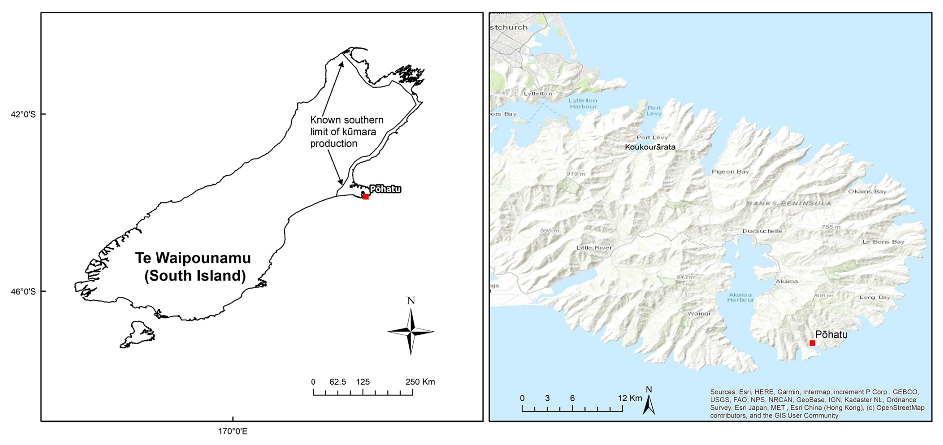
Figure 1Southernmost limit of kūmara production in Te Waipounamu, with the location of the Pōhatu study site indicated. Adapted from Barber (2017).
Kia whakatōmuri te haere whakamua: I walk backwards into the future with my eyes fixed on my past.
1.1 Study context
Pōhatu is situated on the southeastern side of Te Pātaka o Rākaihautū (Fig. 1), for which Te Rūnaka o Koukourārata are Mana Whenua. The bay was the location of the Kāti Mamoe pā, Pae Karoro, translating to Pigeon Breasted, one of three Kati Mamoe pā sites on Te Pātaka o Rākaihautū. Kāti Mamoe occupied the Canterbury region from c.1500 CE, arriving from Te Ika o Maui (North Island). The pā was captured for Kāi Tahu by Tūtakahīkura, one of Moki's warriors (Taylor, 2001), in the early 1700s CE, when Kāi Tahu arrived in Te Wai Pounamu (Payne, 2020). The pā is situated on the hillside overlooking the beach at its southern end and has been the primary focus of previous archaeological investigations in the bay (Brailsford, 1997; Furey, 2006; Ogilvie, 2017; Taylor, 2001). Following the 1849 Port Levy Deed of Purchase, much of the takiwā (area, territory) of Koukourārata, including Pōhatu, was taken against negotiation promises, with only one reserve at Koukourārata provided for Māori, resulting in whānau and hapū living throughout the bays of the tribal land leaving their homes to settle in Koukourārata (Evison, 2006). This displacement as a result of colonisation resulted in a disconnection between the people and their whenua (land). European settlement in Pōhatu began with the establishment of the Flea Bay run by brothers William and George Rhodes ca. 1852 (Acland, 1946, 1951; Ogilvie, 2010) and has since been used for sheep and beef farming, as well as for conservation of environmental heritage in more recent times (Department of Prime Minister and Cabinet, 2021).
Mātauraka Māori associated with Pōhatu includes pūrākau, waiata, and ingoa wāhi. A Kāi Tahu tohuka (expert), Teone Taare Tikao (Kāi Te Kahukura, Kāti Irakehu) discusses the symbiotic relationship between the cultivation and preparation of kūmara and kauru (a sweet food from cooked tī kouka (Cordyline sp.) trunks) in his 1870 manuscripts (Payne, 2020). In the manuscript, Tikao details that kūmara beds are prepared between the different stages of kauru harvesting and preparation, with the kūmara being planted in whitu, the seventh month of the Kāi Tahu māramataka (Māori lunar calendar), corresponding to November in the Gregorian calendar (Payne, 2020). A Kāi Tahu waiata, Manu Tiria, further confirms this. The waiata, recounted to a German missionary in 1874 at Ruapuke Island, Southland, Aotearoa / New Zealand, tells of how the demigod, Māui, shape-shifted into a kererū (Hemiphaga novaeseelandiae, wood pigeon) and flew to the underworld to find out who his father was. The waiata informs us that kūmara is planted during the seventh and eighth months (November and December) (Payne, 2020). The significance of this is in recognising the difference in planting times between warmer northern areas and the cooler south as one of the adaptations required to successfully grow kūmara in what is currently recognised in the literature as the southernmost limit of kūmara production (Barber, 2017; Trotter and McCulloch, 1999).
Additionally, the ingoa wahi, name of the bay, and its associated pūrākau are particularly significant in providing guidance on where to look and what to look for. Pōhatu translates to stone or stony, with oral traditions from Pōhatu and other locations where kūmara was grown, referring to the practice of gravel additions to garden soils to improve drainage and aid in warming (Best, 1976; Brailsford, 1997; Payne, 2020; Rigg and Bruce, 1923; Trotter and McCulloch, 1999). This name was bestowed on the pā in the bay when it became the home of Tūtakahīkura (Beattie, 1990; Payne, 2020). Given the significance of kūmara as a crop for Māori, naming a pā to reflect a practice only used for kūmara production is a clear indicator that this crop was grown here. This name and the pūrākau also provide a strong indication that soils in the kūmara māra will contain gravel. The information from these mātauraka Māori sources provides guidance on where to look and what to look for regarding past Māori food landscapes at Pōhatu.
Pōhatu has previously been of archaeological interest to Brailsford (1997) and Furey (2006). These authors noted the presence of two potential garden areas, with Brailsford (1997) indicating a potentially terraced area at the base of the bay bordered by what appears to be a drainage ditch (Fig. 2B) and Furey (2006) a series of narrow mounds running across a north-facing slope above the present-day farmhouse (Fig. 2D).
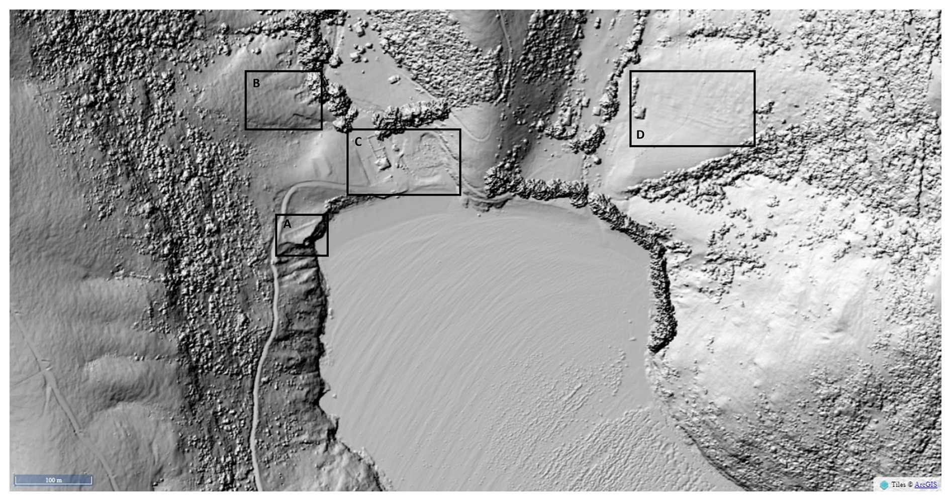
Figure 2Points of interest within Pōhatu: (A) remains of pā wall, (B) potential garden area surrounded by a right-angled drain (Brailsford, 1997), (C) living area (Brailsford, 1997). (D) Mounds running across the slope identified by Furey (2006).
Soils of Te Pātaka o Rākaihautū are formed from either of two parent materials. The primary rock of Te Pātaka o Rākaihautū is basalt, produced during the formation of the peninsula (Dorsey, 1988). In many places, the basaltic parent material has been mantled by loess derived from greywacke sandstone (Griffiths, 1973). A wide range of local climates are present on the peninsula due to the strong relief, with most areas below 750 m reflecting a cool temperate (montane) bioclimatic zone (Soons et al., 2002), with the eastern bays receiving around 1000 mm yr−1 of rainfall (Macara, 2016).
1.2 Kūmara
Kūmara is a root crop of importance for Māori, with both dietary and spiritual significance. Originating from South America, the crop was introduced to the Pacific islands by transoceanic transfers, arriving in Aotearoa / New Zealand during the 12–13th century CE (Barber, 2012; Barber and Benham, 2024; Harburg, 2013). While across most of the Pacific kūmara was only considered to be a minor crop, it was of greater importance in Aotearoa / New Zealand (Barber, 2012; Furey, 2006), possibly due to the scarcity of other significant carbohydrate sources.
A number of challenges had to be overcome to enable crop success in Aotearoa / New Zealand. These include different soil types and different cultivation methods required due to being unable to directly plant tubers in the ground across most of Aotearoa / New Zealand as a result of the colder climate (Best, 1976; Yen, 1961). Māori adapted to these conditions, and kūmara became a staple crop. While kūmara was grown across most of Te Ika-a-Māui, according to writers such as Barber (2017) and Trotter and McCulloch (1999) it is limited to a coastal margin in Te Waipounamu, with Te Pātaka o Rākaihautū and Taumutu, at the southwestern end of Kaitorete spit, marking the southernmost extent of kūmara production (Fig. 1). Māori were the first to manage and crop the soils of Aotearoa / New Zealand, developing extensive knowledge and ethnopedological understandings of the local conditions and unique soils, with over 60 kupu (words) describing their properties and uses (Roskruge, 2011).
Plant microfossils are a useful proxy for exploring the origins and dispersal of domestic plants and the development of agriculture (Kondo et al., 1994). Within the category of microfossils are phytoliths, starch grains, pollen, and xylem cells, which are retained in the soil (Horrocks and Rechtman, 2009). Phytoliths are particles of amorphous hydrated silica that form in the stems and leaves of plants and are deposited in the soil when a plant decays (Kondo et al., 1994). Silicic acid is taken up from the soil solution by plants, which precipitates as hydrated amorphous silica in stems and leaves (Pearsall, 2015). Phytoliths have less complex dispersal patterns than pollen grains, which can be carried by the wind (Horrocks, 2004), and are more resistant to decay than starch and pollen grains (Horrocks and Lawlor, 2006; Horrocks et al., 2002). A classification system for New Zealand was developed by Kondo et al. (1994), which separates phytolith morphotypes into different classes of grasses, trees, and ferns based on the terminology used in Japan and Europe (Carter, 2002). This has since been adopted for use in phytolith analysis in New Zealand (Carter and Lian, 2000). Additionally, the International Code for Phytolith Nomenclature (ICPN) 2.0, published in 2019 (International Committee for Phytolith Taxonomy, 2019), provides a standardised description of phytolith morphotypes to support the growing number of phytolith studies.
There have been few studies that have included the identification of kūmara phytoliths in Aotearoa / New Zealand. In a study of two stone mounds in Porerua (Northland, New Zealand), Horrocks et al. (2000) identified a small number of smooth, round phytoliths, most likely from the pre-European kūmara variety, rekamarua, based on the work of Carter (2001).
A study of a 1 ha area of modified soils at Okuora Farm on Banks Peninsula by Bassett et al. (2004), which sits adjacent to Waikākahi Pā, identified phytoliths of a spherical smooth morphotype, consistent with the phytoliths extracted from modern kūmara leaves by Carter (2001). Bassett et al. (2004) note the similarities between the phytoliths from kūmara and those extracted from beech, kamahi, rātā, and pōhutukawa, which persist on the peninsula. The main difference from beech (excluding silver beech) is the verrucose surface of the phytolith (Fig. 6c), which is rough in comparison to the smooth morphotype of kūmara phytoliths (Bassett et al., 2004; Carter, 2001).
To guide the TDR approach for weaving mātauraka Māori and soil science, we applied the He Awa Whiria (braided rivers) framework developed by Macfarlane et al. (2015). The He Awa Whiria framework identifies two streams of knowledge involved in the research (Fig. 3), each of equal value and each with its own epistemological foundations, methods, and modes of analysis. The mātauraka Māori stream involved the application of mātauraka Māori and kaupapa Māori methods and analysis. Kaupapa Māori refers to the methods and approaches developed and informed by te ao Māori (Māori worldview) and tikaka Māori (Māori customary protocols, procedures, and rules); in other words, it refers to research done by Māori, for Māori, and with Māori (Smith, 2015). The soil science stream mirrors the mātauraka Māori stream, comprising soil science knowledge, methods, and analysis. At times, these streams interact with each other, creating a space of mutual learning. At other times, the streams are separate, recognising that it is important to consider each of the knowledges separately to maintain their individual integrity (Macfarlane et al., 2015; Saunders et al., 2023). The imagery of a braided river demonstrates that while the knowledges work towards a common goal, they converge, diverge, and meander along the way (Macfarlane et al., 2015).
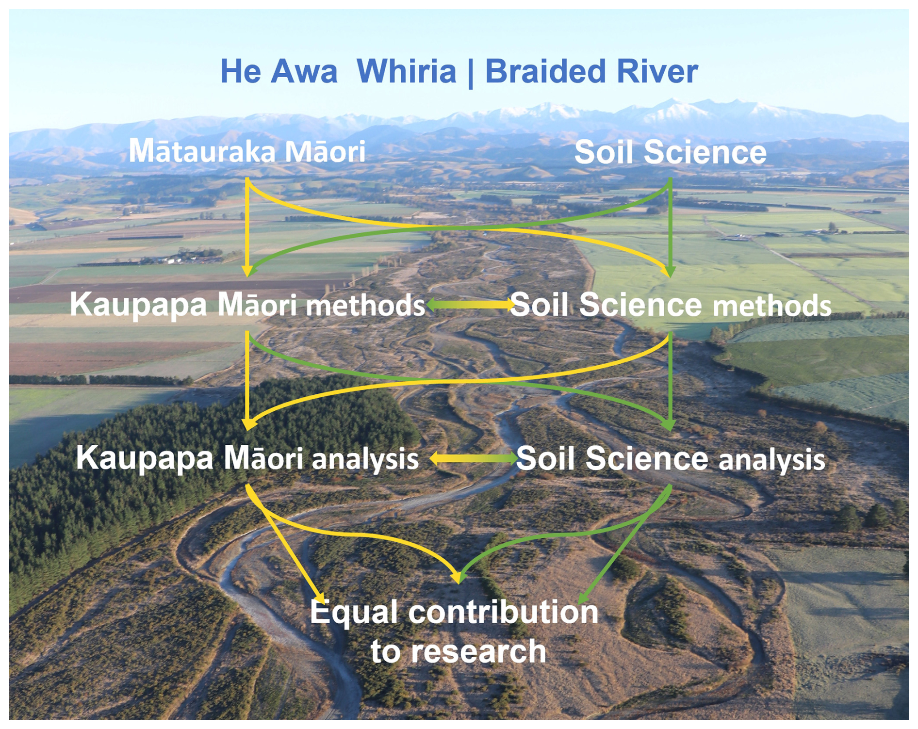
Figure 3The He Awa Whiria model. Adapted from Macfarlane et al. (2015) and Wilkinson et al. (2020).
Retaining the integrity of the knowledges involved is a critical concern of knowledge holders in both streams. Historical and ongoing interactions of Western science with Indigenous knowledge have been extractive, treating Indigenous knowledge and people as research subjects (Saunders et al., 2023; Smith, 2021). Conversely, there is an enduring concern within the scientific community that prioritising societal concerns may introduce individuals who lack the required expertise in the knowledge production process, leading to a loss of scientific quality (Bouma, 2015). Saunders et al. (2023) discuss the tensions between researchers, knowledge holders, and stakeholders, who stress the importance of finding an “appropriate balance” between producing new knowledge and recognising who this knowledge is for. The He Awa Whiria framework addresses these concerns by acknowledging the importance of respecting and retaining the integrity of both knowledge streams. It allows for flexibility, ensuring that the knowledge systems can operate independently when appropriate (Macfarlane et al., 2015; Saha et al., 2023; Wilkinson et al., 2020).
This framework is also accompanied by the whakataukī, “nā tō rourou, nā taku rourou, ka ora ai te iwi: with your food basket and my food basket, the people will prosper”. This whakataukī speaks to the foundations of this research, bringing together the two different knowledge systems to answer the questions of Mana Whenua more comprehensively than either of the knowledges alone are able to do in this context (Macfarlane et al., 2015; Wilkinson et al., 2020).
The He Awa Whiria framework is suitable for research teams with any ratio of Māori to non-Māori due to the dynamic nature of the knowledge streams converging and diverging throughout the research process (Wilkinson et al., 2020). Nevertheless, a level of humility is required throughout research guided by this framework, particularly by non-Māori researchers trained in Western science disciplines that have a privileged status in relation to mātauraka Māori (Smith, 2021). We were mindful of these power dynamics as we embarked on this research as a team of Pākehā (New Zealander of European descent, JG), Māori (MP, DP), and Tauiwi (settler/recent migrant, SE, DJ, CS, JC), and a guiding principle of this research was to counter the power imbalance that occurs between Western science disciplines and mātauraka Māori. While JG was the overall project leader, she was guided through the research by DP, who also enabled the connection with Mana Whenua at Te Rūnaka o Koukourārata, including the key holder of mātauraka Māori (MP). Furthermore, as a research team, we built genuine and nurturing relationships with each other through the course of this research. We provide details of the engagement with Mana Whenua and mātauraka Māori in the following section.
3.1 Engagement with Mana Whenua
A crucial first step for this research was to build a relationship with Mana Whenua and learn about the issues they faced on their whenua, including the aspirations they held for future land use. This began with whakawhanaungatanga (relationship building), which predominantly took place at Koukourārata starting in October 2020, where JG engaged with whānau to support a māra kai project in Koukourarata (Port Levy), which involved planting a range of Māori and non-Māori potatoes for the community. The leader of this project was MP, the then Chair of the Rūnaka and key holder of mātauranka Māori and māra kai for the hapū. As such, this relationship was already established when the opportunity to undertake this study at Pōhatu was identified. One of the areas of interest for MP was revitalising the planting and harvesting of kūmara in the Koukourarata takiwā (area) and recalled the pūrakau of Pōhatu Pā and waiata referencing the planting time in Te Waipounamu. He also mentioned the methods of warming the soil to combat the colder climate and was keen to discover whether those stories could be validated. Utilising that information, a project was co-developed, and permissions were gained from the current landowners and MP as Mana Whenua for this research to be carried out. As additional support, DP, who was Deputy Vice Chancellor, Māori and Pasifika, and leader of Matauraka Māori research at Te Whare Wānaka o Aoraki Lincoln University, joined the research project as a co-supervisor.
A preliminary trip to Pōhatu occurred for the primary focus areas to be determined in April 2022. Soil sampling occurred in May 2022 (see Sect. 3.2), and soils were analysed by JG (see Sect. 3.3). During the analysis period (May 2022–July 2023), initial findings were discussed by JG, MP, and DP, with a physical resource produced to support these discussions and the interpretation of the findings. This was in the form of a folder and included maps, digital elevation models, graphs, photographs, and descriptions and was left with Mana Whenua for the findings to be readily shared with other whānau members. During these discussions, a number of questions that were raised in the interpretations when applying a soil science lens were addressed, and further pathways for analysis and evaluation were identified. These were then pursued with further work, and the overall findings were presented to Mana Whenua, with ongoing discussion occurring, demonstrating the weaving of knowledges throughout the research process. Key interactions are described alongside the findings in Sect. 4, with a detailed discussion of the process of weaving knowledges provided in Sect. 5.
3.2 Site selection and sampling
An initial auger survey across the slopes identified by Brailsford (1997) and Furey (2006) identified buried soil horizons and small greywacke sandstone gravel in area D identified by Furey (2006) (Fig. 2), while evidence of māra was not clear on slope B (Fig. 2). Therefore, in this paper, we investigate the slope with an earthen–raised mound field system, identified in Fig. 2D. Transects were augured to a depth of 1 m across the hillslope identified in Fig. 2D, perpendicular to the raised earth lines, both on and between the mounds. This confirmed that part of the slope had been influenced by a landslide with soil material of a lighter colour, finer texture, and lower permeability, burying darker soil horizons. From this, two pit locations were identified, one on the non-landslide part of the slope and the other on the part that had been disturbed by the landslide (Fig. 4). Pits were then hand-dug to a depth of 100 cm, described following Milne et al. (1995) and classified according to the New Zealand Soil Classification (Hewitt, 2013). The profile was sampled by horizon to a depth of 100 cm for soil and phytolith analyses. Samples were air-dried and sieved to 2 mm in preparation for soil analysis.
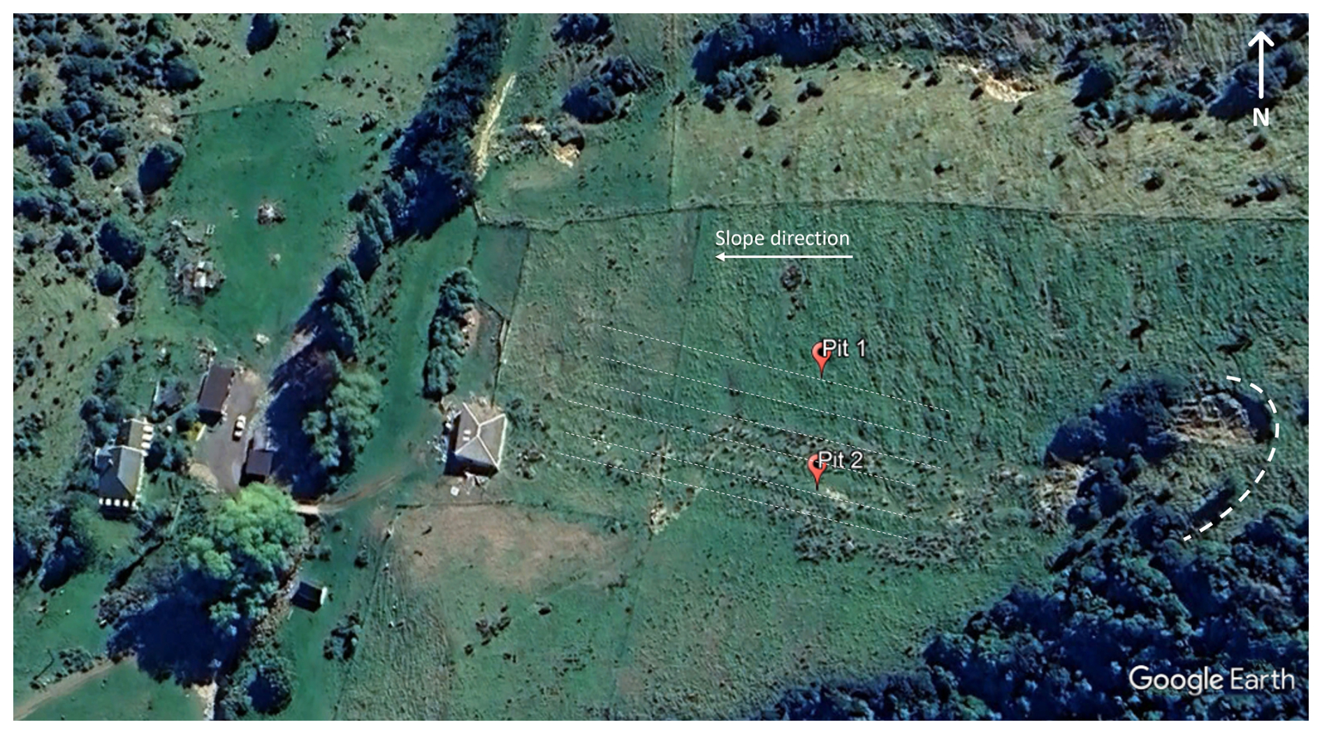
Figure 4Location of soil pits. Raised mound positions are indicated by straight dashed lines. The origin of the landslide is indicated to the right of the image by the curved line. © Google Earth.
3.3 Soil analysis
3.3.1 Microfossil extraction and classification
Extraction of phytoliths from soil samples was based on the methods of Carter (2001) and Parr et al. (2001). A minimum of 300 counts were performed for each slide under plane-polarised light at 400× magnification (Olympus BX53-P), requiring 5–15 fields of view. Phytoliths were classified into one of 12 different phytolith morphotypes, including an “other” category for unidentifiable forms.
Phytoliths were described using Kondo et al. (1994) to draw comparisons with previous New Zealand research. Correlation to the ICPN 2.0 (International Committee for Phytolith Taxonomy, 2019) has also been provided to align with universally accepted nomenclature and classification. The work of Carter (2001) and Bassett et al. (2004) was used in identifying potential kūmara phytoliths, alongside extractions of fresh plant material. Diatoms were also counted, but taxonomic identifications were not made.
Starch grain extraction followed the methods of (Horrocks, 2005), and grains were counted under cross-polarised light at 100× magnification (Olympus BX53-P). The full area of the coverslip (22 mm×22 mm) was systematically examined, and the total number of starch grains was counted. A classification system for starch, as exists for phytoliths, is absent, with starch grains identified by comparisons to reference collections (Arráiz et al., 2016).
Charcoal extraction followed the method of Rhodes (1998), where 2.0 g samples were digested with 6 % H2O2 and counted in a petri dish under a stereoscope (Nikon SMZ645) with top lighting at 40× magnification. Samples were moistened prior to observation to increase their lustre and aid in differentiating the charcoal from other dark organic fragments in the sample. Samples were systematically scanned and the total number of fragments in the petri dish was counted.
Analysis of microfossil counts used the tidypaleo package in R (Dunnington et al., 2022), where phytolith counts were converted to percentages and displayed as frequency diagrams, with starch and charcoal counts presented.
3.3.2 Soil signatures
Soil samples from soil horizons with evidence of modification in the earthen–raised mound system were radiocarbon-dated at the University of Waikato using accelerator mass spectrometry (AMS). Stable isotope analysis for δ15N and δ13C was completed at Lincoln University by elemental analyser continuous-flow isotope ratio mass spectrometry (EA–CF/IRMS; Sercon GSL/20–22). ICP–OES was used to determine the trace element concentrations of soils and plants, with samples prepared using nitric acid microwave digestion to analyse for As, Ca, Cd, Cr, Cu, K, Mg, Mn, Mo, Ni, Pb, and Zn (Agilent ICP–OES5110).
4.1 Soil profile
Six earth rows, angled at approximately 45° to the slope, were identified. The initial auger survey identified that three of these earthen–raised mounds appear to have been influenced by the landslide indicated in Fig. 4, with a yellowish-brown horizon (10 YR 5/4) present between the topsoil and a very dark brown (10 YR 2/2) underlying a buried A horizon containing fine to medium greywacke sandstone beach gravel. One pit was dug in the area not influenced by the landslide (Pit 1), and the second (Pit 2) was dug on a raised mound within the landslide influenced area (Figs. 4 and 5). Soil profile descriptions are presented in Tables 1 and 2. An absence of large charcoal or woody remains was noted in the profiles, including in the modified horizons. Clay content increased with depth, and there were no observed increases in the sand content within any horizon, with particular attention paid to those that were modified. Evidence of modification included the presence of fine to medium (20–60 mm) rounded greywacke sandstone gravel, which contrast with the autochthonous angular basalt clasts (20–100 mm) in the unmodified soil horizons.
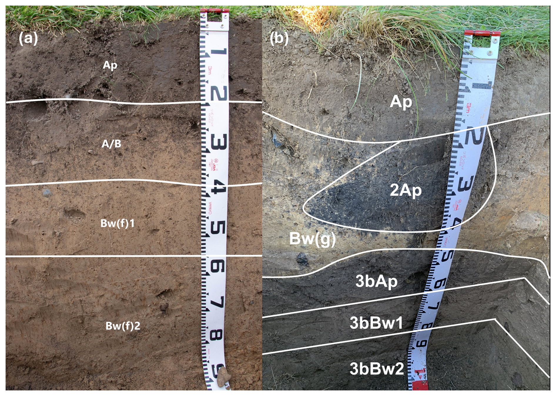
Figure 5(a) Pit 1, without landslide disturbance. Arrows indicate beach gravel additions to the soil. (b) Landslide-influenced soil (Bw(g) is the landslide material), covering the original soil surface (bAp), with modification present in the 2Ap. Beach gravel was present in the 2Ap and 3bAp horizons. Numbers on the tape measure are at 10 cm intervals.
Table 1Soil profile description of Pit 1, described according to Milne et al. (1995) and classified as a Typic Orthic Melanic Soil (Hewitt, 2010) (Haplustepts, Soil Survey Staff, 1999). Horizon notations: Ap=an A horizon with evidence of cultivation; A/B=a transitional horizon with discrete parts that have recognisable properties of both master horizons; Bw(f)=a weathered B horizon with 2 % or more redox segregations without low chroma colours on ped faces or in the matrix. All colour values are moist colours. Texture abbreviations: ZL=silt loam, ZC=silty clay. Polyhedral=majority of angles between faces are <90° when viewed from outside the solid. blocky=majority of angles between faces are >90° when viewed from outside the solid.
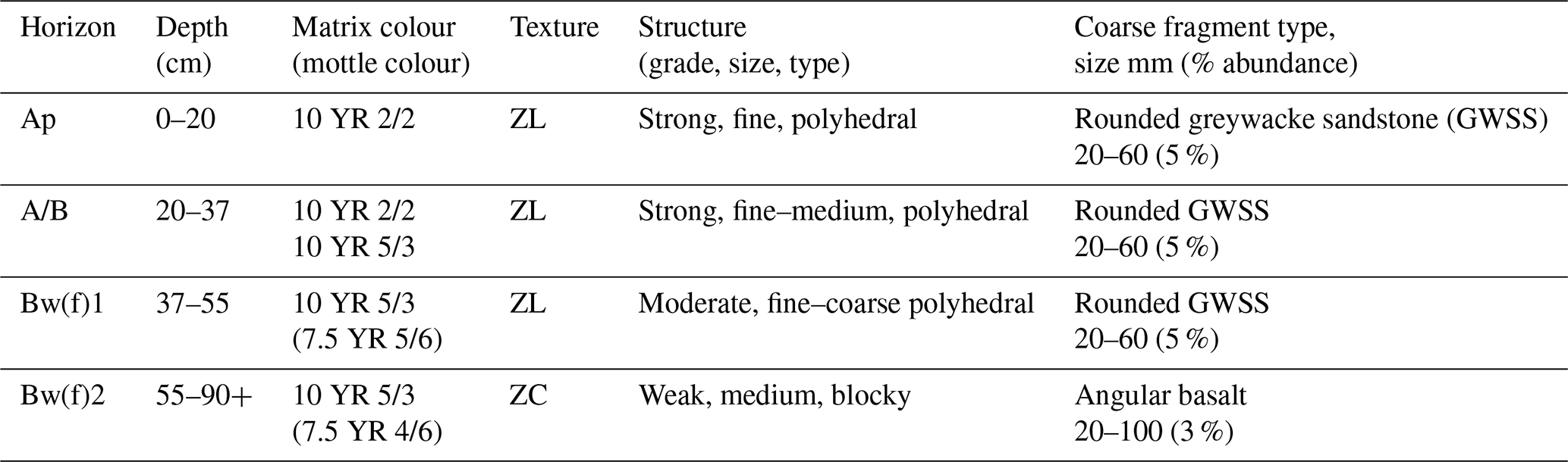
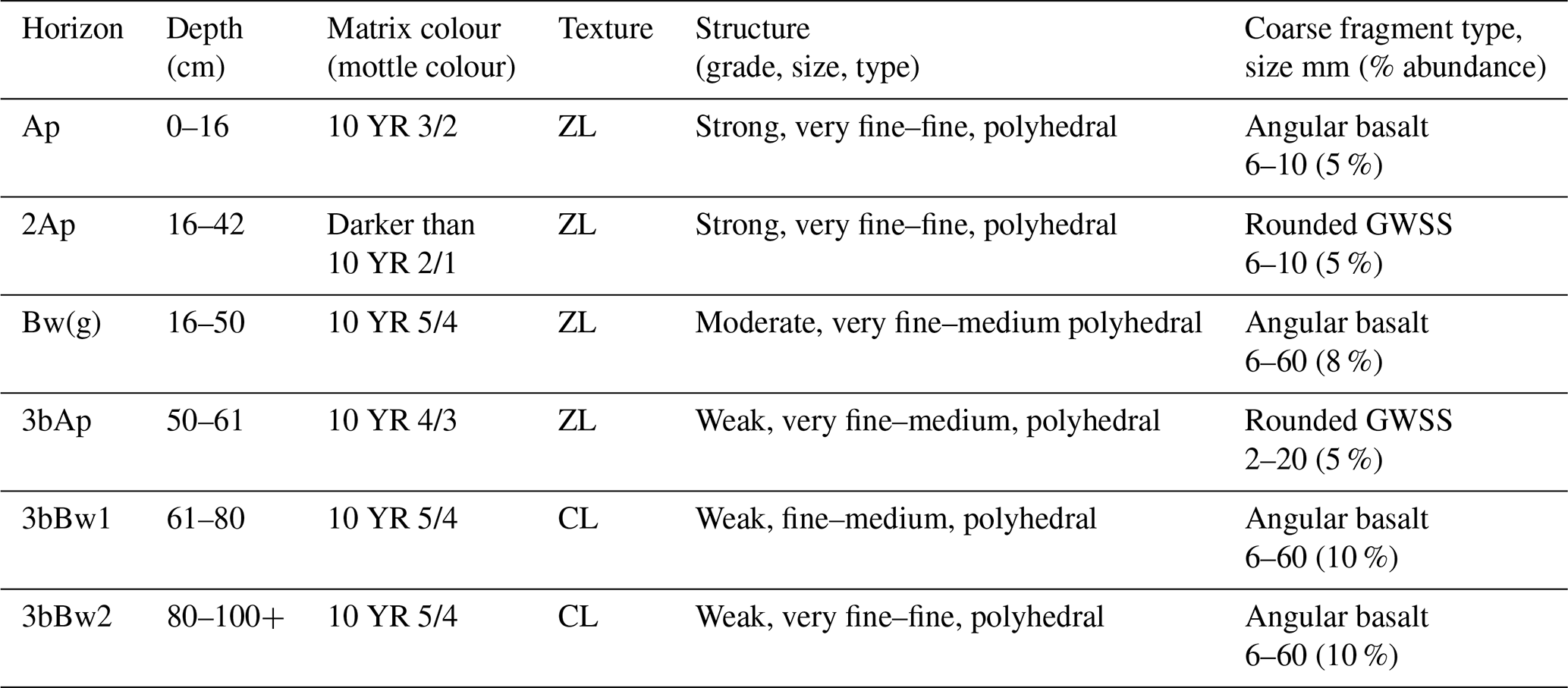
Table 2Soil profile description for Pit 2. The soil has been described according to Milne et al. (1995) and classified as a Mottled Mafic Melanic Soil (Hewitt, 2010) (Udolls or Haplustepts, Soil Survey Staff, 1999). Horizon notations: the numerical prefix (2, 3) signifies a lithological discontinuity, b= a buried genetic horizon, Bw(g)=a weathered B horizon with 2 % or more redox segregations with low chroma colours that are occupying<50 % of the matrix and not dominant on ped faces. Texture abbreviations: CL=clay loam.
Pūrakau associated with the chief of Pōhatu Pā, Tūtakahīkura, informs us that the pā was named to acknowledge the gravel added to the soil to increase the soil temperature and improve drainage, creating more suitable growing conditions for kūmara (Payne, 2020). As this practice was only used for kūmara and considered wholly unnecessary for other crops (Trotter and McCulloch, 1999), the presence of gravel in the modified soil horizons is a clear indicator that kūmara was grown at Pōhatu. Analysis of soils on the slope with earthen–raised mounds, identified by Furey (2006), revealed the presence of small, rounded greywacke sandstone gravel (2–6 mm) in horizons with darker soil colourings, contrasting with the autochthonous angular basalt clasts present in the remainder of the profile. Owing to the elevation and aspect of this slope, it is not possible for this rounded gravel to have been emplaced in these soils by any surface processes or other agents of transport, such as tsunami deposits. An increase in sand content is a feature reported in modified soil horizons to lighten the soil (McFadgen, 1980b), which is noticeably absent in the modified horizons of the Pōhatu soils. This could be due to the strongly structured nature of the Melanic Soil material allowing for drainage and the additions of gravel being sufficient in retaining temperature for kūmara production.
Alongside the additions of beach gravel to the soil, properties of the soil profile indicate modification for kūmara production, particularly in Pit 2. Due to the continued weathering and pedological development of the soil in Pit 1, which has not been influenced by a landslide, modifications are not as obvious as those in Pit 2. In Pit 2, the pocket of dark 2Ap soil material developed into the Bw(g) landslide deposit (Fig. 5b) resembles kūmara pits in other Te Waipounamu locations throughout Aotearoa / New Zealand identified by Barber and Higham (2021) and Gumbley et al. (2004). In other locations, particularly in Te Ika-a-Māui, kūmara māra consists of individual mounds, termed puke (Best, 1976; Furey, 2006; Gumbley et al., 2004; Walsh, 1902), but do not appear in archaeological investigations in Waitaha (including Bassett et al., 2004; Furey, 2006; Jacomb, 2000; Morris, 1994). These individual puke are not present at Pōhatu; however, the pocket of enriched material in the 2Ap horizon of Pit 2 indicates that a similar planting arrangement may have been used within the continuous rows. Enriched pockets in elongated earthen–raised mounds have not been reported elsewhere and are likely to have arisen from the need to recommence kūmara production in the poorer-quality landslide material. The soil material of the landslide deposit had the physical properties of a Pallic Soil (Fragiudalfs, Fragiochrepts, Haplustepts; Soil Survey Staff, 1999), formed from loess, which are highly susceptible to erosion (Hewitt et al., 2021). The use of elongated earthen–raised mounds does not appear in the literature beyond sites identified on Te Pātaka o Rākaihautū (Brailsford, 1997; Furey, 2006; Jacomb, 2000; Morris, 1994). Being located at the southern limits of kūmara production, reducing the exposed surface area of individual puke may have served the purpose of retaining soil temperature while still raising the plants in mounds as is common practice for kūmara (Best, 1976; Law, 1969; McFadgen, 1980a; Trotter and McCulloch, 1997; Walsh, 1902; Yen, 1961).
Previous archaeological investigations at Pōhatu have not looked below the surface, which has left questions as to the composition of the earthen–raised mounds identified by Furey (2006). Similar surface features at māra sites on Te Pātaka o Rākaihautū have been identified as stone rows (Bassett et al., 2004; Furey, 2006; Harrowfield, 1969; Jacomb, 2000; Morris, 1994), defined by Walton (1999) as elongated heaps of stone. No stone rows were identified at Pōhatu, with our investigation indicating that the raised mounds presented in Furey (2006) are earthen.
4.2 Microfossil analysis
Phytolith counts of 300 phytoliths per slide, requiring 5–15 fields of view, were completed for each horizon in the two soil pits. Elevated numbers of phytoliths with a spherical smooth morphotype (Fig. 6a and b), consistent with phytoliths extracted from modern kūmara leaves and previous phytolith research (Bassett et al., 2004; Carter, 2001; Horrocks and Rechtman, 2009; Horrocks et al., 2000), were observed in the modified soil horizons of both pits. Notably, these phytoliths displayed a line of grooves at the hemisphere, absent in other phytoliths with spherical smooth morphotypes from native tree species, including beech, kamahi, rātā, and pōhutakawa (Bassett et al., 2004). Furthermore, starch grains (Fig. 7) were present in and below modified soil horizons (Fig. 8). This supports the mātauraka Māori of kūmara production at Pōhatu.
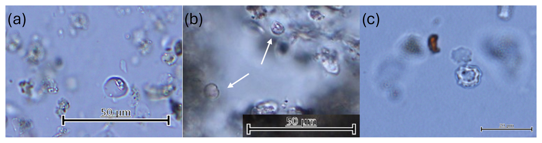
Figure 6(a) Spherical smooth phytoliths extracted from Pōhatu soil sample 2Ap of WS13. (b) Spherical smooth phytoliths isolated from modern kūmara leaf. (c) Spherical verrucose phytolith from Pōhatu soil sample. The scale bar is 50 µm for (a) and (b) and 25 µm for (c).
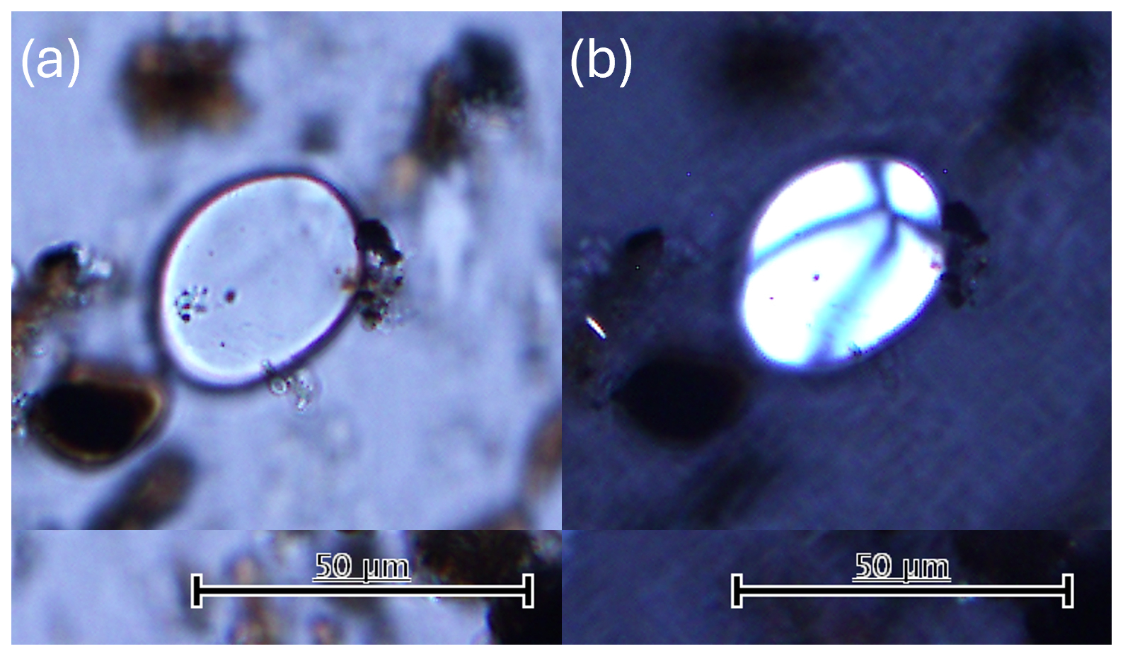
Figure 7(a) Starch grain extracted from the 2Ap horizon of Pit 2 (b) viewed under cross-polarised light, showing the Maltese cross, characteristic of kūmara grains. The scale bar is 50 µm.
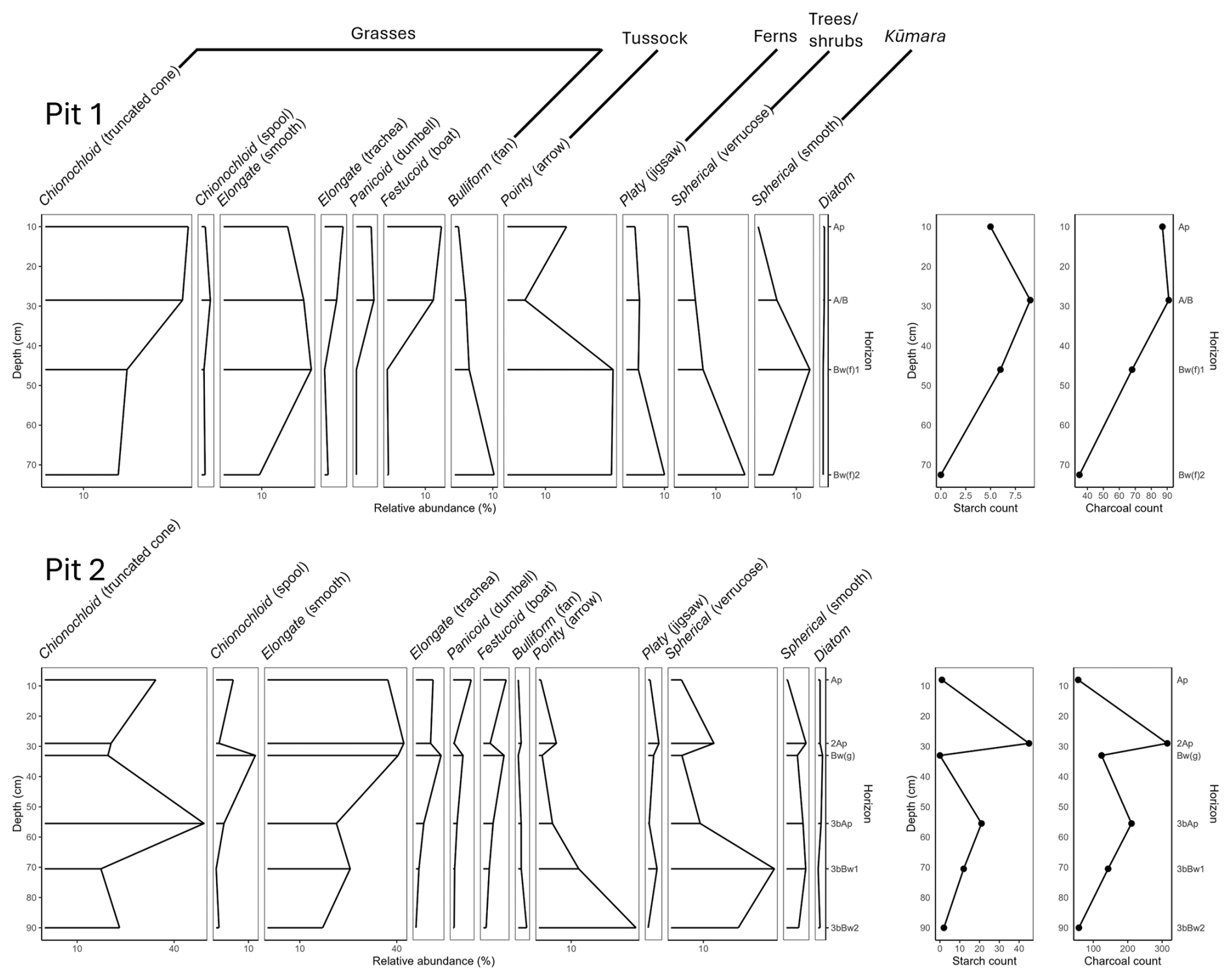
The elevations of spherical smooth phytoliths corresponded to an overall decrease in phytoliths with spherical verrucose and point-shaped (arrow) morphotypes from the 3bBw3 of Pit 2 through to the present-day topsoil, indicating that more trees and tussock grasses were present in this environment prior to soil modification (Fig. 8). An increase in grass phytoliths with an elongated smooth morphotype occurred in the Bw(f)1 soil horizons of Pit 1, where the beach gravel was located. This increase is also observed in the 2Ap horizon of Pit 2, becoming more abundant above the 3bAp, from the time of the landslide. In Pit 2, increases in platy jigsaw phytoliths, associated with ferns, and diatoms were observed in the modified horizons, indicating that ferns and marine materials may have been soil amendments to develop the growing beds. An increase in phytoliths associated with warmer-climate grasses was present in the Bw(g) of Pit 2, with fewer identified in the modified 2Ap, before increasing again in the modern-day topsoil. A spike in truncated cone chionochloid phytoliths is visible in the 3bAp horizon, indicating that plants such as toetoe (Austrideria spp.) may have been added in reasonable volumes to enrich this horizon. Toetoe are abundant across Aotearoa / New Zealand, found in almost all environments, with many uses by Māori, including as a building material, bedding, wound treatment, weaving, and medicinal purposes (Hiroa, 1949; Scheele and Sweetapple, 2024; Tipa, 2012); however, there is no record of it being used as a soil amendment.
While no large charcoal fragments were visible in the soil profiles, charcoal fragments (<500 µm) were identified in considerable amounts in the modified soil horizons, with over 300 fragments counted per 2.0 g unit of soil from the 2Ap horizon of Pit 2 (Fig. 8). This increase, and a smaller spike in the 3bAp horizon of Pit 2, indicates potential ash additions to enhance the soil or the burning of in situ vegetation to clear the land between growing periods. The comparison between Pits 1 and 2 indicates that both are likely to have occurred, with a higher concentration of charcoal in the modified horizons than the horizons containing gravel in Pit 1.
4.3 Soil amendments
Trace element analysis identified an increase in manganese (Mn) concentrations in the modified horizons (Fig. 9), while the other trace elements analysed showed little variability across the different horizons. The increase in Mn was considered to potentially arise from soil amendments to improve kumara growth. Initially, seaweed and penguin guano were considered as potential fertiliser sources based on the work of Morris (1994). An examination of māra soils at Panau and Kirikiriwaerea (Menzies Bay), near bays on Te Pātaka o Rākaihautū, investigated the influence of penguin guano and seaweed fertiliser additions as soil amendments (Morris, 1994). This study noted that soils with penguin influence were dark-coloured, particularly in pale-coloured loess-derived soils, indicating that Mg, Ca, and K concentrations were lower in soils influenced by penguins. Due to manure of all kinds traditionally prohibited as a soil amendment due to being considered tapu (sacred, prohibited, restricted) by Māori (Best, 1976), intentional addition of guano to the soil is perhaps an unlikely practice (Furey, 2006), despite its potential availability at Pōhatu as a kororā (little blue penguin, Eudyptula minor) colony. Mātauraka Māori for Kirikiriwaerea identify seaweed as an important fertiliser for māra soils (Morris, 1994), which leads to elevations in As, B, Mn, and Cd and a decrease in Mo (Blanz et al., 2019). Increases in these trace element metals were also not observed at Pōhatu, where Mn was elevated in both modified horizons, and Mo increased in the 2Ap horizon. These trends were not observed in the modified horizons at Pōhatu, where an increase in Mn was the key observation for the modified horizons, with lower levels of Mg, Ca, and K than reported for Panau and Kirikiriwaerea.
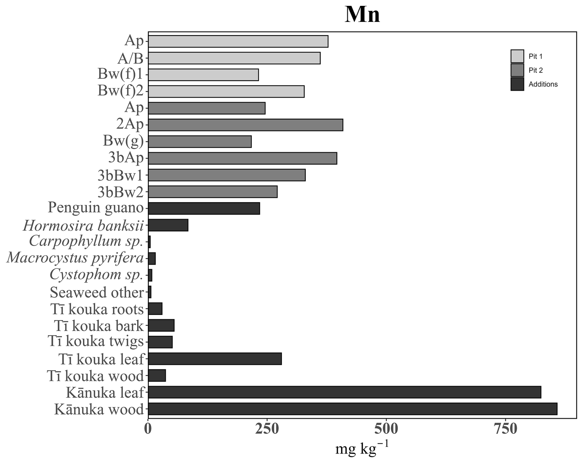
Figure 9Mn concentrations in soil horizons and potential inputs. The A/B horizon in Pit 1 and the 2Ap and 3bAp horizons in Pit 2 are modified. Seaweeds = Hormosira banksii, Carpophyllum sp., Macrocystus pyrifera, Cystophom sp., and seaweed other.
All Pōhatu seaweed samples were high in As, Ca, K, and Mg, while the rimurimu (Macrocystis pyrifera, giant kelp) species was also high in Cd and Cr, and Cystophora was high in Mo. However, seaweed and guano did not correspond to elevations of this trace element in the modified soil horizons. The increase in Mn in the modified soil horizons of Pit 2 exceeds the concentrations found in the penguin guano and seaweed samples analysed, suggesting that these are not nutrient sources in the Pōhatu māra soils. This finding led to discussions with Mana Whenua to identify other potential fertiliser sources. In their paper on mātauraka Māori technologies, Payne (2020) discusses the interconnectedness between the practices of kūmara cultivation and mahika kauru, an important carbohydrate source extracted from tī kouka. This prompted an expansion of the trace element micronutrient and stable isotope analyses to include different parts of the tī kouka tree.
Further literature review also highlighted the use of mānuka (Leptospermum scoparium; tea tree) and kānuka (Kunzea ericoides; white tea tree) as palisades around garden areas and as fast-establishing plants during fallow periods, which were burnt in situ to clear the māra for the next planting season (Rigg and Bruce, 1923; Walsh, 1902). Rigg and Bruce (1923) note the enduring fertility of the modified Māori soils with mānuka ash additions on the Waimea Plains, which were highly sought after by European growers. Analysis by Miller et al. (1955) of soils (not Māori modified soils) where a stand of mānuka was burnt concluded that the addition of ash resulted in nutrient levels comparable to those released to soils through the application of common fertilisers. As the more abundant of these two species in the study area, known particularly for its rapid re-establishment following fire (Harris and Harris, 1939; Wilson, 1994), kānuka was also analysed.
The concentration of Mn in the kānuka samples was higher than in the modified soil horizons, suggesting kānuka as a likely fertiliser source. Tī kouka bark and leaves showed elevations of Ca, Cr, Cu, K, and Zn; however, these did not correspond to the trace element concentrations present in the soil and did not strongly indicate it as a likely soil addition. Neither kānuka nor tī kouka produce phytoliths (Horrocks, 2004; Kondo et al., 1994) and thus cannot be cross-checked through this method. An analysis of the soil pollen record may be a potential option to investigate this further; however, pollen recovery following prolonged heat/fire exposure is poor (Ghosh et al., 2006). Heat and fire destroy pollen grains, and due to the long cooking time for tī kouka and depending on the burning practices for kānuka, pollen grains are unlikely to be present even if parts of these trees were used as fertilisers.
Further soil enhancement may have stemmed from experience in working with the different soils that occur at Pōhatu, capitalising on the geochemical properties of the soils. Māori have extensive knowledge of soil properties and capabilities, with over 60 terms for soils (Harmsworth and Roskruge, 2014; Roskruge, 2020). As the second of three shields that form the Te Pātaka o Rākaihautū volcanic complex, the primary parent material of the peninsula is mildly alkaline basalt (Stipp and McDougall, 1968). These rocks are high in Mg and Fe oxides, released during weathering to form strongly structured Melanic Soils (Haplusteps, Udolls; Soil Survey Staff, 1999) with high fertility (Hewitt, 2010; Price and Taylor, 1980). The second parent material of the soils in the study area is loess, blown across the Canterbury Plains during interglacial periods, that mantles parts of the peninsula, forming Pallic Soils. These deposits are predominantly of a silty texture, produced from greywacke sandstone containing quartz and plagioclase feldspars (NaCaSi3O8 to CaAl2Si2O8) as the dominant mineralogy (Griffiths, 1973; Raeside, 1964). This quartzofeldspathic material results in Pallic Soils that are low in free iron and ferromagnesian minerals (Hewitt, 2010; Raeside, 1964). These soils have low permeability and lower fertility than those formed from basalt.
Within Pit 2, soils from both of these parent materials are present. Soils of basaltic origin form the original soil profile, and the paler soil material of loess origin comprises the landslide layer. This landslide layer (Bw(g)) had a lower Mn concentration than the original subsoil horizons (Fig. 9), derived from basaltic parent material. The Mn concentration in both modified horizons of Pit 2 exceeds that of either soil of the two parent materials, indicating that organic additions that are high in Mn have been used to enrich the soil. The highest concentration of Mn is in the 2Ap horizon, developed into the loess soil deposit. Mixing Melanic Soil material, along with the organic additions previously discussed, may have contributed to this high concentration. These naturally richer soils may have been recognised as superior for kūmara based on experience within the bay and sought as a base to develop a highly fertile soil. This potentially came from recognising that the Pallic Soil material is poor for growing and the Melanic Soil material is more suitable for kūmara production. The properties of the Melanic Soils of Pōhatu align with the Māori description of kirikiri tuatara, a brown, friable, and fertile soil that is suited to kūmara production, while the landslide material is better described as onetuatara, a stiff brown soil needing amendment with sand or gravel to suit kūmara (Roskruge, 2020).
In addition to soil and plant trace element concentrations, the stable isotopes δ13C and δ15N have been used to identify potential sources of enrichment for the modified māra soils. A slight enrichment of δ13C (less negative values) in the 2Ap horizon (extensively modified) of the slope with raised earth lines indicates a different input source than those contributing to other soil horizons, with potential additions of C4 terrestrial plants or marine sources. As the only known C4 plants to become naturalised in Aotearoa / New Zealand are pastoral grasses (Crush and Rowarth, 2007), with no known native or endemic species, it is improbable that these were added, with seaweeds or other marine additions being more plausible. The main C4 species include maize, sugar cane, and sorghum, which were absent in Aotearoa / New Zealand until the arrival of Europeans. All soil samples fall within the δ13C range of terrestrial C3 plants (−34 ‰ to −22 ‰) identified by Hawke and Clark (2010). Some seaweeds, including Macrocystis pyrifera (giant kelp), have been reported to follow photosynthesis pathways that are more aligned with C4 plants (Yanhui and Zhigang, 2016), which results in less negative δ13C values. All soil δ13C values (−28.49 to −25.13) are within the expected range of influence by C3 terrestrial plants (−34 ‰ to −22 ‰; Hawke and Clark, 2010). A less negative δ13C value in the 2Ap horizon of Pit 2 indicates that small amounts of marine-sourced nutrients, such as seaweeds (−20.6 ‰ and −13.3 ‰), have potentially been added to the soil. Penguin guano δ13C (−25.91 ‰ to −27.07 ‰) was more negative than expected based on the findings of Hawke and Clark (2010), and δ15N was lower than observed in other locations, such as the Atacama, Chile, where additions were used (Santana-Sagredo et al., 2021) (Fig. 10).
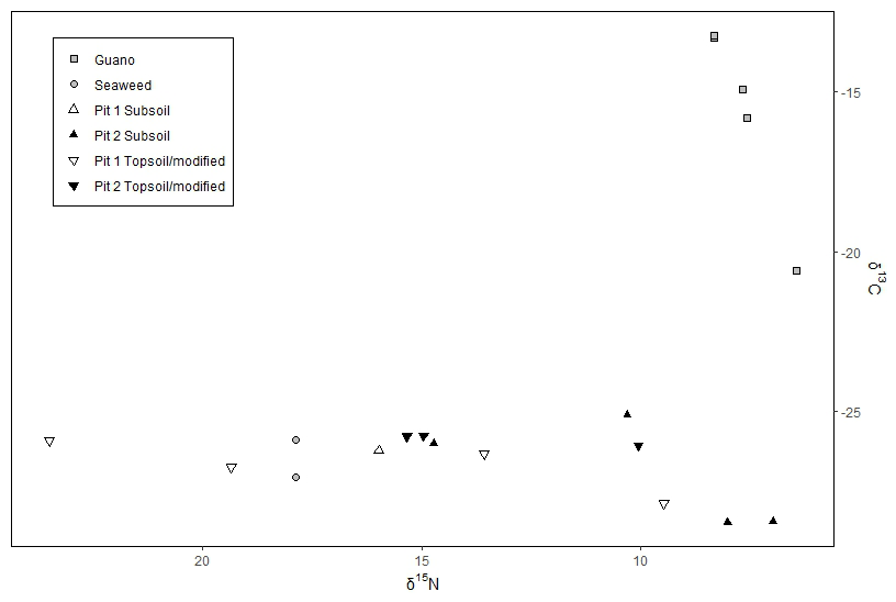
Figure 10Stable isotope ratio for Pits 1 and 2, with potential organic additions of seaweed and penguin guano.
The peak of δ13C in the 2Ap horizon reflects the findings of other studies where an increase in organic matter has been observed (Wilson et al., 2007). In forested canopies, when leaves are incorporated into topsoil, fresh leaf litter accumulations retain the more negative δ13C values, which are then slowly degraded by bacteria (and isotopically fractioned) towards less negative δ13C values (Rogers et al., 2017). Marine sources also reflect a less negative δ13C (Kinaston et al., 2013), as demonstrated in the analysed seaweed samples. It is possible that small amounts of seaweed were added to develop the 2Ap horizon, but the ash of C3 plants was likely the primary addition.
4.4 Radiocarbon dates
Mātauraka Māori for Pōhatu is associated with Kāi Tāhu occupation. Mātauraka Māori informs us that Kāi Tāhu arrived ca. 1620 CE (Payne, 2020). However, the mātauraka Māori does not indicate whether māra were present upon arrival. If māra were present at this point, it would indicate previous cultivation by Kāti Māmoe or if Kāi Tahu initiated kūmara production at Pōhatu. This uncertainty raises the following question: did the name Pōhatu, referring to the additions of gravel to the soil, arise from what was observed upon arrival, or was the name decided after this practice began for Kāi Tāhu planting? Other studies recognise that Kāti Māmoe were growing kūmara in other areas within Waitaha (Law, 1969), making it plausible that kūmara was being grown at Pōhatu prior to the arrival of Kāi Tāhu.
To determine when the māra were in use, radiocarbon dating was conducted on the modified soil horizons in Pits 1 and 2 on the slope with earth lines (Fig. 2D). The dates obtained for the 2Ap horizon of Pit 2, 279±19 (1680 CE), align with Kāi Tāhu occupation. The radiocarbon date obtained for the original māra layer, b3Ap of Pit 2, was 662±16 (1400 CE), predating the arrival of Kāti Māmoe in Te Wai Pounamu, which occurred ca. 1500 CE (Beattie, 1990). The date of the soil material from where the rounded gravel was in the greatest abundance for Pit 1 was 1175±17 (370 CE), predating any known settlement in Aotearoa / New Zealand. An absence of large pieces of charcoal or woody material in the modified soil layers resulted in radiocarbon dating being obtained from bulk soil samples for each of the modified horizons, overestimating the dates of the soils, indicating them as older than their most recent organic inputs.
The bulk sample analysis of radiocarbon by AMS incorporates different pools and fractions of C within the soil, which have different stabilisation mechanisms, resulting in obscured information on the distribution of the radiocarbon age of the soil organic matter (Rosenheim et al., 2013; Stoner et al., 2022). Consequently, the radiocarbon ages obtained are likely to be older than when these soils were used as māra, as the date accounts for both old, recalcitrant C and young, more labile C added to the soil as organic matter. This issue is particularly relevant for the gravel-modified layer in Pit 1 and the 3bAp horizon in Pit 2, where the radiocarbon dates do not appear to accurately reflect the most recent additions of C to the soil, making it difficult to determine when the māra were in use. Based on the results of the radiocarbon dating analysis and mātauraka Māori, it remains unclear whether the māra were in use by Kāti Māmoe before the arrival of Kāi Tāhu in the early 1700s. The radiocarbon date determined for the 2Ap horizon of Pit 2 is likely more accurate due to the large amounts of microscopic charcoal in the soil.
These findings provide a preliminary understanding of land use and connections between people and soil through food production at Pōhatu. There is an opportunity for further investigation at this site to identify and explore other potential cultivated areas, as well as to more comprehensively study the earthen–raised mound system to provide further certainty to the findings presented in this paper. The process and learning from undertaking this transdisciplinary study are reflected in the following section.
This case study has explored the interface between mātauraka Māori and soil science in a place-based context. The He Awa Whiria framework was critical in conceptualising and guiding the weaving of knowledges in this research and ensuring meaningful engagement throughout the research process. This approach allowed both mātauraka Māori and soil science to contribute equally alongside each other, ensuring that the research is holistic and culturally informed and enabling us to answer the research questions more comprehensively than either knowledge alone could have.
Our research demonstrates the value of engaging with knowledge outside of the Western science paradigm through genuine and non-extractive interactions with mātauraka Māori. While recognising mātauraka Māori as a knowledge system of equal value to Western science, it has also been possible to maintain scientific integrity. This demonstrates that there is space for both knowledges, with each having a distinct role and contribution. Mātauraka Māori has guided and informed the research questions and context while soil science methods are applied to conduct the soil analysis. The scientific rigour of the study is maintained through applying conventional soil science methods. Yet the significance of the findings, such as identifying where kūmara were produced and horticultural practices used, are validated through the acceptance and interpretation of the findings by Mana Whenua, concluding that the findings support mātauraka Māori for kūmara production at Pōhatu. This approach respects both the scientific and cultural dimensions of the research, ensuring that neither knowledge stream is subsumed by the other.
Of equal importance to retaining the individual integrity of the knowledges is facilitating and utilising mutual learning opportunities (Macfarlane et al., 2015). These opportunities arose when the knowledge streams of He Awa Whiria intersected (Cram et al., 2018; Macfarlane and Macfarlane, 2018; Wilkinson et al., 2020). Discussions around the soil science findings, their alignment with existing knowledge, and how they fit within broader understandings of the relationships between soil, food, and people in this landscape contributed to developing a more complete picture of past land use at Pōhatu. In instances where soil science results were inconclusive, mātauraka Māori provided guidance on what to consider next.
To facilitate discussion and interpret findings, a folder of information was prepared and provided to Mana Whenua. This folder served as a connector, aiding communication of the scientific results. It included maps, images, descriptions of all potential sites within the bay, annotated photographs of the soil profiles, phytolith stratigraphs, graphs of micronutrient concentrations, stickers with questions, suggested interpretations from a soil science lens, diagrams, and additional observations beyond the primary focus area of potential interest to Mana Whenua. This format enabled easy reference during discussions.
A timeline of occupation and activities at Pōhatu was also part of the resource, which included dates from known oral histories and traditions and findings from this study. The timeline became a focal point of discussion, with further detail added during the discussion, including names and dates of notable movements and events, providing further context and supporting interpretation of the original research questions. The folder was a key resource for engaging the two knowledge streams within the mutual learning area of the He Awa Whiria framework.
The interaction between the knowledges in this case study provided an opportunity to develop a more complete understanding of past horticultural land use and support the rediscovery of māturaka Māori, which neither knowledge alone would have been able to achieve. With mātauraka Māori having been lost and degraded over time as a result of colonisation, there is an opportunity to engage the mātauraka Māori that has persisted with another knowledge, such as soil science, to look back in time and affirm or rebuild aspects of mātauraka Māori to reconnect with the whenua. Where these knowledges interact, the strengths of both are harnessed and enhanced through mutual learning. Figure 11 illustrates the research process as it has occurred in this study, following the form of the He Awa Whiria framework. The contributions of each knowledge stream are clearly identifiable, along with the mutual learning that emerged from their interaction.
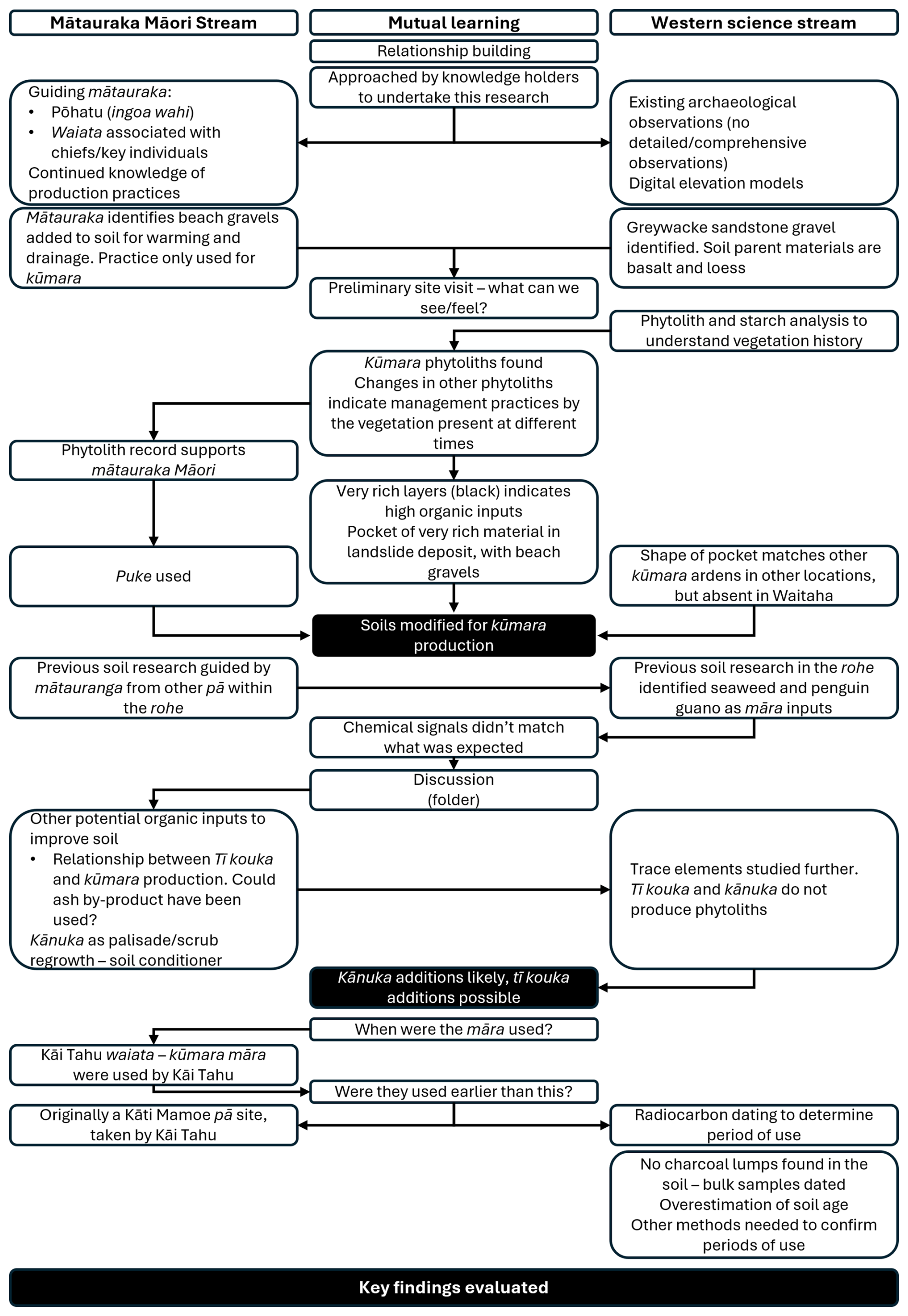
Figure 11Schematic application of the He Awa Whiria framework in this case study of understanding past food landscapes at Pōhatu.
An example of the interaction between the knowledges occurred while attempting to identify what the soils had been fertilised with, as presented in Sect. 4.4. The potential for seaweed and penguin guano fertilisers initially considered was identified from other studies within the takiwā (Jacomb, 2000; Morris, 1994), with the identification of the seaweed source in one of these studies coming from mātauraka Māori (Morris, 1994). The initial micronutrient analysis in the Pōhatu case study found that these were not likely to have been significant inputs to the māra soils. This finding was discussed with Mana Whenua, who suggested that tī kouka ash may have been a potential source of nutrients due to the association of its harvesting time being aligned with kūmara planting, as discussed by Payne (2020). Tī kouka is processed by cooking pounded roots and stems in large ovens, called umu tī, to produce kauru, a sugary substance important as a carbohydrate source (Best, 1976; Payne, 2020). It was proposed that the ash by-product from this process could have been applied to the māra as a fertiliser. The micronutrient analysis and principal component analysis (PCA) suggest that this is worth further investigation, with some parts of the tree reflecting the nutrients identified in the soil, with kānuka also being a likely input. Further examples of the interaction between knowledges are presented in Fig. 11.
The guidance the He Awa Whiria framework provides to researchers, knowledge holders, and stakeholders involved who are external to at least one of the knowledge streams is valuable and ensures that each stream is constantly front of mind throughout the research process. The He Awa Whiria framework has facilitated the weaving of mātaruaka Māori and soil science in identifying past horticultural land use at Pōhatu, ensuring that knowledges are considered and applied with equal value without prioritising one over the other. In addition to the findings that support mātauraka Māori and the potential for Mana Whenua to rediscover and redevelop māra at this location, the process of applying the He Awa Whiria framework has provided several key lessons and understandings when doing TDR and the value of extending the boundaries of soil science into a transdisciplinary space.
A fundamental aspect of TDR is engagement, which is reliant on establishing relationships built on mutual trust and understanding with stakeholders, Indigenous knowledge holders, and researchers from other disciplines (Robson-Williams et al., 2023; Scholz, 2011; Stein et al., 2024). Relationships are a critical factor in working beyond the boundaries of soil science through TDR (Bouma et al., 2015; Keesstra et al., 2016). This involves fostering interdisciplinary collaborations to integrate insights from various scientific disciplines and facilitate non-academic engagement (Bennich et al., 2020; Hansson and Polk, 2018; Hirsch Hadorn et al., 2008; Lang et al., 2012). Additionally, embedding Indigenous lenses and engaging with diverse stakeholders can provide a more comprehensive understanding. The application of the He Awa Whiria framework in this study has demonstrated how the knowledge of stakeholders can guide and inform soil science and the value of utilising mutual learning opportunities through means of engagement that avoided structured interviews as extractive interactions and allowed for more open shared learning. Mutual learning cannot occur in isolation when the knowledges are applied and engaged with in isolation. This contrasts with how Western science is usually conducted, which often operates in silos, forming part of an important but disjointed picture at times (Gibbons et al., 1994; Lönngren and van Poeck, 2021). The benefits of research at the interface between knowledges are only realised when relationships are genuine and strong. The Pōhatu case study has provided an example of this through ongoing engagement and discussion with Mana Whenua throughout the research process, building on the relationships established prior to the identification of the research questions.
Self-awareness is essential when developing meaningful relationships. Thus, positionality is a crucial element in engaging with a TDR methodology, despite being an uncommon practice in the biophysical sciences. Positionality involves reflecting on the grounds on which one is engaging with the research and how they are prepared to approach the challenge (Hausermann and Adomako, 2022). This requires recognition and reflection of the researchers' biases, beliefs, cultural background, and experiences which can influence the research outcomes, as well as the research process (Bourke, 2014), which is particularly important in TDR. By incorporating this self-awareness, TDR applications involving soil scientists can strive for greater objectivity and account for the potential influence of researchers' backgrounds on their interpretations and findings (Brown, 2023).
Soils tell a story of the environment and its history. Across most of the landscape, these stories are predominantly about the climate, plants and animals, and the factors that resulted in its formation (Jenny, 1941). These stories can be read and understood by soil scientists and contribute to understanding the capabilities and limitations of the soil for production, conservation, and land use. In other places, these stories of the environment are interwoven with the stories of people present in these places and how they interact with their environment. To fully understand these stories, more than soil science is needed. While soil science can identify the words that make up the story, it is the relationships with people and their place-based knowledge that give meaning to the properties of the soil, enabling the story to be told.
This case study and other local examples (for example, McFadgen and Adds, 2019) weave together knowledges to address research questions identified by Mana Whenua. Lessons from these applications can be applied when addressing global sustainability and soil security challenges in local contexts, identified as needed by the NSF-AC-ERE (2022). In recognising the importance of place-based knowledge and approaches (Ramaswami et al., 2022; Saunders et al., 2023), opportunities to move beyond the boundaries of soil science can be realised. Lessons from the Pōhatu case study have supported the development of the recently proposed Food-Landscape Networks framework, which aims to apply a holistic approach to understanding the (dis)connections between soil, food, and people in local, place-based contexts (Gillespie et al., 2024).
TDR is a different way of doing science. Knowledge production through applying a TDR approach is inherently complex due to its iterative and collaborative nature. It challenges the linear methods often used by Western-trained researchers by moving beyond disciplinary boundaries and practices that characterise the Western scientific knowledge production (Gibbons et al., 1994). Our case study contributes to establishing a valuable foundation for understanding the interface of different knowledge systems, providing insights for other researchers looking to move beyond disciplinary boundaries.
A key part of this study has been to approach these knowledges with an open mind and consider the whole of the environment in understanding connections. Smith (2021), in discussing Cook's voyage to Aotearoa / New Zealand, reflects on Banks' description of the people as using the “same detached eye” (p. 94) as used for their descriptions of the flora and fauna. In contrast, people and social aspects are considerations that cannot be separated from the environment in mātauraka Māori (Hikuroa, 2017). By responding to the needs, questions, and priorities of local and Indigenous communities – alongside them – Western science begins to relinquish some of the power it has monopolised in research and investigation (Anthony-Stevens and Matsaw Jr., 2020; Lauter, 2023). This shift in power does not diminish the status of Western science. Rather, it elevates local and Indigenous knowledge and knowledge holders, recognising and valuing their ontological and epistemological foundations (Anthony-Stevens and Matsaw Jr., 2020; Chapman and Schott, 2020; Henri et al., 2021; Hill et al., 2020; McGregor et al., 2010). Although this transition is a confronting and uncomfortable process, it is necessary. As soil scientists, if we do not move beyond disciplinary boundaries, how can we truly address the complex challenges that society faces and will continue to face?
By weaving together mātauraka Māori and soil science, understandings of past horticultural land use at Pōhatu have been advanced. The findings of this study indicate that kūmara was grown where the soils have been modified with gravel additions. Soils were primarily fertilised with organic material from terrestrial plants, likely dominated by kānuka. It is evident from both mātauraka Māori and radiocarbon dating that kūmara production occurred during Kāi Tāhu occupation of the bay that alternative methods are required to determine if Kāti Mamoe were also growing kūmara here prior to the arrival of Kāi Tāhu. This study provides a preliminary understanding of cultivation history at Pōhatu, and there is opportunity to explore this further to develop a more comprehensive understanding of this landscape, continuing to weave together mātauraka Māori and soil science. Furthermore, this study has provided an example of activating the He Awa Whiria framework. In the Pōhatu case study, mutual learning at the intersection of knowledges occurred multiple times, with mātauraka Māori providing context or identifying next steps when understanding and interpreting the findings and results obtained using soil science methods. While this is only one of the many conceptual frameworks that have been developed, its application involving soil science provides guidance for TDR.
In this example, mātauraka Māori provided guidance on where to look and what to look for, and then soil science methods were applied to build on this and identify relevant details. Through ongoing engagement and relationship building, the findings were considered and interpreted in the context of mātauraka Māori. Interpreting the results by applying soil science only does not tell the complete story; however, when combined with mātauraka Māori, a more complete and meaningful understanding was achieved. While the case study presented is situated in an Aotearoa / New Zealand context, the learning regarding how these knowledges can interact, considerations when approaching questions relevant to different stakeholders, and the value of guiding frameworks are applicable and provide guidance for working with Western science and Indigenous knowledge in other place-based contexts.
Soil science alone cannot sufficiently understand and address the complex global challenges rooted in soil security. This case study has demonstrated the value of weaving together soil science and Indigenous knowledge to understand the connections between soil and people in place-based contexts. Weaving knowledges provides the opportunity to consider different ways of knowing the environment and the way people operate within it and as part of it, leading to approaching complex challenges with a broader range of tools to identify and pursue meaningful and sustainable outcomes.
| Hapū | Sub-tribe, kinship group |
| He Awa Whiria | Braided river |
| Ingoa Wahi | Names |
| Kai | Food, to eat |
| Kaupapa Māori | Māori principles and approaches |
| Kauru | Edible stem of Tī kouka (Cordyline spp. cabbage tree) |
| Kūmara | Sweet potato (Ipomea batatas) |
| Mana Whenua | Māori community with customary authority over the land |
| Māra/māra kai | Garden, food garden |
| Māramataka | Māori lunar calendar |
| Mātauraka Māori | Māori knowledge, understanding |
| Mōteatea | Lament, traditional chant |
| Pā | Fortified village, fort, stockade, screen |
| Pākeha | Non-Māori New Zealander of European descent |
| Pepeha | Tribal saying or motto, proverb, saying of the ancestors |
| Puke | Hillock, mound |
| Pūrakau | Stories, legends |
| Rūnaka | Tribal governance council of a Hapū or Iwi |
| Takiwā | District, area, territory |
| Te Ao Māori | Māori worldview |
| Tauiwi | Settler, recent migrant |
| Tikaka | Customary protocols, procedure, method, rule |
| Tohuka | Expert |
| Waiata | Song, chant |
| Whaikōrero | Speech, formal speech-making, oration, address |
| Whānau | Extended family, family group |
| Whakapapa | Genealogy, lineage, descent |
| Whakataukī | Proverb |
| Whenua | Land, ground, placenta |
The code is available at https://github.com/paleolimbot/tidypaleo (last access: 29 August 2025).
Data will be made available on request.
JG: conceptualisation, fieldwork, methodology, data acquisition, data curation, formal analysis, data interpretation, visualisation, writing and editing (original draft and review and editing); MP: knowledge provision, conceptualisation, data interpretation, writing (reviewing); DP: relationship establishment, conceptualisation, methodology, data interpretation, writing (reviewing and editing); SE: conceptualisation, methodology, writing and editing (original draft and review and editing); DJ: methodology, data interpretation, writing and editing (original draft and review and editing); CS: conceptualisation, methodology, data interpretation, writing (reviewing and editing); JAC: conceptualisation, methodology, data interpretation, writing (reviewing and editing).
The contact author has declared that none of the authors has any competing interests.
Publisher's note: Copernicus Publications remains neutral with regard to jurisdictional claims made in the text, published maps, institutional affiliations, or any other geographical representation in this paper. While Copernicus Publications makes every effort to include appropriate place names, the final responsibility lies with the authors.
This research was completed as part of a PhD at Te Whare Wanaka o Aoraki Lincoln University in Aotearoa / New Zealand. We also thank Mana Whenua of Koukourārata for the opportunity to work alongside you in the māra, the Helps family for sampling access at Pōhatu, and the Pōhatu Penguins team for hosting us.
This research has been supported by the Lincoln University Joint Postgraduate School scholarship and Manaaki Whenua Landcare Research.
This paper was edited by Jeffrey Homburg and reviewed by Jonathan Sandor, Joe Watkins, and one anonymous referee.
Acland, L. G. D.: Rhodes's cattle station at Akaroa – (part of run 30, block ii) – the early Canterbury runs: Containing the first, second and third (new) series, Whitcombe and Tombs Limited, Christchurch, https://ndhadeliver.natlib.govt.nz/webarchive/20201108000000/https://nzetc.victoria.ac.nz/tm/scholarly/tei-AclEarl-t1-body-d12-d2.html (last access: 29 August 2025), 1946.
Acland, L. G. D.: The early Canterbury runs: and glossary of station words, complete edn., Whitcombe & Tombs, Christchurch, New Zealand, 1951.
Anthony-Stevens, V. and Matsaw Jr., S. L.: The productive uncertainty of indigenous and decolonizing methodologies in the preparation of interdisciplinary STEM researchers, Cultural Studies of Science Education, 15, 595–613, https://doi.org/10.1007/s11422-019-09942-x, 2020.
Anthony, C.: Towards an Indigenous Transdisciplinarity, Transdisciplinary Journal of Engineering and Science, 8, 127–150, https://doi.org/10.22545/2017/00091, 2017.
Arráiz, H., Barbarin, N., Pasturel, M., Beaufort, L., Domínguez-Rodrigo, M., and Barboni, D.: Starch granules identification and automatic classification based on an extended set of morphometric and optical measurements, J. Archaeol. Sci., 7, 169–179, https://doi.org/10.1016/j.jasrep.2016.03.039, 2016.
Ball, B. C., Hargreaves, P. R., and Watson, C. A.: A framework of connections between soil and people can help improve sustainability of the food system and soil functions, Ambio, 47, 269–283, https://doi.org/10.1007/s13280-017-0965-z, 2018.
Barber, I.: A fast yam to Polynesia: New thinking on the problem of the American sweet potato in Oceania, Rapa Nui Journal 26, 31–42, 2012.
Barber, I.: New radiocarbon ages clarify chronology of Waimea Plains Māori settlement and dry agronomy, Northern Te Waipounamu, Journal of Pacific Archaeology, 8, 103–107, 2017.
Barber, I. and Benham, R. W.: American sweet potato and Asia-Pacific crop experimentation during early colonisation of temperate-climate Aotearoa/New Zealand, Antiquity, 98, 1–19, https://doi.org/10.15184/aqy.2024.143, 2024.
Barber, I. and Higham, T. F. G.: Archaeological science meets Māori knowledge to model pre-Columbian sweet potato (Ipomoea batatas) dispersal to Polynesia's southernmost habitable margins, PLoS One, 16, e0247643, https://doi.org/10.1371/journal.pone.0247643, 2021.
Bassett, K. N., Gordon, H. W., Nobes, D. C., and Jacomb, C.: Gardening at the edge: Documenting the limits of tropical polynesian kūmara horticulture in southern New Zealand, Geoarchaeology, 19, 185–218, https://doi.org/10.1002/gea.10116, 2004.
Beattie, H.: Tikao talks: ka taoka tapu o te ao kohatu: treasures from the ancient world of the Maori, Penguin, Auckland, New Zealand, ISBN 0140138889, 1990.
Bennich, T., Maneas, G., Maniatakou, S., Piemontese, L., Schaffer, C., Schellens, M., and Österlin, C.: Transdisciplinary research for sustainability: scoping for project potential, Int. Soc. Sci. J., 72, 1087–1104, https://doi.org/10.1111/issj.12245, 2020.
Best, E.: Māori ori agriculture: the cultivated food plants of the natives of New Zealand, with some account of native methods of agriculture, its ritual and origin myths, Govt. Printer, Wellington, New Zealand, 1976.
Black, A. and Tylianakis, J. M.: Teach Indigenous knowledge alongside science, Science, 383, 592–594, https://doi.org/10.1126/science.adi9606, 2024.
Blanz, M., Ascough, P., Mainland, I., Martin, P., Taggart, M. A., Dieterich, B., Wishart, J., Sayle, K. L., Raab, A., and Feldmann, J.: Seaweed fertilisation impacts the chemical and isotopic composition of barley: Implications for analyses of archaeological skeletal remains, J. Archaeol. Sci., 104, 34–44, https://doi.org/10.1016/j.jas.2019.02.003, 2019.
Bouma, J.: Implications of the knowledge paradox for soil science, in: Advances in Agronomy, Chapt. 4 edited by: Sparks, D. L., Academic Press, 143–171, https://doi.org/10.1016/S0065-2113(10)06004-9, 2010.
Bouma, J.: Engaging soil science in transdisciplinary research facing “wicked” problems in the information society, Soil Sci. Soc. Am. J., 79, 454–458, https://doi.org/10.2136/sssaj2014.11.0470, 2015.
Bouma, J. and McBratney, A.: Framing soils as an actor when dealing with wicked environmental problems, Geoderma, 200–201, 130–139, https://doi.org/10.1016/j.geoderma.2013.02.011, 2013.
Bouma, J., Kwakernaak, C., Bonfante, A., Stoorvogel, J. J., and Dekker, L. W.: Soil science input in transdisciplinary projects in the Netherlands and Italy, Geoderma Regional, 5, 96–105, https://doi.org/10.1016/j.geodrs.2015.04.002, 2015.
Bourke, B.: Positionality: Reflecting on the Research Process, Qualitative Report, 19, 1–9, https://doi.org/10.46743/2160-3715/2014.1026, 2014.
Brailsford, B.: The tattooed land, 2nd edn., Stoneprint Press, Hamilton, New Zealand, ISBN 0958350221, 1997.
Brevik, E. C., Cerdà, A., Mataix-Solera, J., Pereg, L., Quinton, J. N., Six, J., and Van Oost, K.: The interdisciplinary nature of SOIL, SOIL, 1, 117–129, https://doi.org/10.5194/soil-1-117-2015, 2015.
Brevik, E. C., Slaughter, L., Singh, B. R., Steffan, J. J., Collier, D., Barnhart, P., and Pereira, P.: Soil and human health: Current status and future needs, Air Soil and Water Research, 13, 1178622120934441, https://doi.org/10.1177/1178622120934441, 2020.
Brown, D.: Non-indigenous positionality when engaging in de-colonising/re-indigenising research and its place within visual methodology, Int. J. Qual. Meth., 22, 16094069231159794, https://doi.org/10.1177/16094069231159794, 2023.
Carter, J. A.: Phytolith analysis of kūmara and gourd: A method of providing direct evidence of pre-historic farming in Ancient Polynesia, in: Phytolith and starch research in the Australian-Pacific-Asian regions: the state of the art, edited by: Hart, D. M. and Wallis, L. A., Vol. 19, 127–136, Australian National University, 2001.
Carter, J. A.: Phytolith analysis and paleoenvironmental reconstruction from Lake Poukawa Core, Hawkes Bay, New Zealand, Global Planet. Change, 33, 257–267, https://doi.org/10.1016/S0921-8181(02)00081-4, 2002.
Carter, J. A. and Lian, O. B.: Palaeoenvironmental reconstruction from the last interglacial using phytolith analysis, southeastern North Island, New Zealand, J. Quaternary Sci., 15, 733–743, https://doi.org/10.1002/1099-1417(200010)15:7<733::AID-JQS532>3.0.CO;2-J, 2000.
Chakraborty, R., Jayathunga, S., Matunga, H. P., Davis, S., Matunga, L., Eggers, J., and Gregorini, P.: Pursuing plurality: Exploring the synergies and challenges of knowledge co-production in multifunctional landscape design, Frontiers in Sustainable Food Systems, 5, 680587, https://doi.org/10.3389/fsufs.2021.680587, 2022.
Chapman, J. M. and Schott, S.: Knowledge coevolution: generating new understanding through bridging and strengthening distinct knowledge systems and empowering local knowledge holders, Sustain. Sci., 15, 931–943, https://doi.org/10.1007/s11625-020-00781-2, 2020.
Cheik, S. and Jouquet, P.: Integrating local knowledge into soil science to improve soil fertility, Soil Use Manage., 36, 561–564, https://doi.org/10.1111/sum.12656, 2020.
Cram, F., Vette, M., Wilson, M., Vaithianathan, R., Maloney, T., and Baird, S.: He awa whiria – braided rivers: Understanding the outcomes from Family Start for Māori, Evaluation Matters – He Take Tō Te Aromatawai, 4, 165–206, https://doi.org/10.18296/em.0033, 2018.
Crush, J. R. and Rowarth, J. S.: The role of C4 grasses in New Zealand pastoral systems, New Zeal. J. Agr. Res., 50, 125–137, https://doi.org/10.1080/00288230709510287, 2007.
da Silva, J. F., Neto, M. F., Portela, J. C., Gondim, J. E. F., de Melo, S. B., de Freitas, D. F., de Medeiros, J. F., da Silva Dias, N., Peixoto, T. D. C., and da Silva Sá, F. V.: Soil Classification Based on Local and Scientific Knowledge in an Irrigated District in the Semi-Arid Region of Brazil, Land, 13, 1559, https://doi.org/10.3390/land13101559, 2024.
Department of Prime Minister and Cabinet: Queen's Birthday Honours 2021 – Citations for Members of the New Zealand Order of Merit. Department of Prime Minister and Cabinet, https://www.dpmc.govt.nz/honours/lists/qb2021-mnzm#helpsfr (last access: 14 November 2023), 2021.
Dorsey, C. J.: The geology and geochemistry of Akaroa volcano, Banks Peninsula, New Zealand, Doctor of Philosophy, University of Canterbury, https://doi.org/10.26021/6464, 1988.
Dunnington, D. W., Libera, N., Kurek, J., Spooner, I. S., and Gagnon, G. A.: tidypaleo: Visualizing Paleoenvironmental Archives Using ggplot2, J. Stat. Softw., 101, 1–20, https://doi.org/10.18637/jss.v101.i07, 2022.
Durie, M.: Exploring the interface between science and indigenous knowledge, 5th APEC Research and Development Leaders Forum, Christchurch, New Zealand, https://www.massey.ac.nz/documents/486/M_Durie_Exploring_the_interface_Between_Science_and_Indigenous_knowledge.pdf (last access: 29 August 2025), 2004.
Evison, H.: The Ngāi Tahu deeds: a window on New Zealand history, Canterbury University Press, Christchurch, New Zealand, 2006.
Forster, M.: Working at the interface of Te Ao Māori and social science, New Zealand Sociology Special Issue: When Mana Whenua and Mana Moana Make Knowledge, 37, 211–232, 2022.
Friedrichsen, C. N., Mizuta, K., and Wulfhorst, J. D.: Advancing the intersection of soil and well-being systems science, Soil Security, 6, 100036, https://doi.org/10.1016/j.soisec.2022.100036, 2022.
Furey, L.: Māori gardening: an archaeological perspective, Department of Conservation, Wellington, New Zealand, ISBN 047814122X, 2006.
Ghosh, R., D'Rozario, A., and Bera, S.: Can palynomorphs occur in burnt ancient potsherds? An experimental proof, J. Archaeol. Sci., 33, 1445–1451, https://doi.org/10.1016/j.jas.2006.01.015, 2006.
Gibbons, M., Limoges, C., Nowotny, H., Schwartzman, S., Scott, P., and Trow, M.: Evolution of knowledge production, in: The new production of knowledge: The dynamics of science and research in contemporary societies, SAGE Publications Ltd., London, 23–45, https://doi.org/10.4135/9781446221853.n2, 1994.
Gillespie, J., Cavanagh, J.-A., Edwards, S., Jolly, D., Payne, D., and Smith, C.: A transdisciplinary approach for assessing connections between soil, food, and people in Aotearoa New Zealand, Eur. J. Soil Sci., 75, e13521, https://doi.org/10.1111/ejss.13521, 2024.
Griffiths, E.: Loess of Banks Peninsula, New Zeal. J. Geol. Geop., 16, 657–675, https://doi.org/10.1080/00288306.1973.10431388, 1973.
Gumbley, W., Higham, T. F. G., and Lowe, D. J.: Prehistoric horticultural adaptation of soils in the middle Waikato Basin: review and evidence from S14/201 and S14/185, Hamilton, New Zealand Journal of Archaeology, 25, 5–30, 2004.
Hansson, S. and Polk, M.: Assessing the impact of transdisciplinary research: The usefulness of relevance, credibility, and legitimacy for understanding the link between process and impact, Res. Eval., 27, 132–144, https://doi.org/10.1093/reseval/rvy004, 2018.
Harburg, J.: Cumal to Kūmara: The voyage of the sweet potato across the pacific, Hohonu, 6, 6–11, https://hilo.hawaii.edu/campuscenter/hohonu/volumes/ documents/CumaltoKumara-TheVoyageoftheSweetPotatoAcross thePacific JennaHarburg.pdf (last access: 29 August 2025), 2013.
Harcourt, N., Awatere, S., Hyslop, J., Taura, Y., Wilcox, M., Taylor, L., Rau, J., and Timoti, P.: Kia Manawaroa Kia Puawai: enduring Māori livelihoods, Sustain. Sci., 17, 391–402, https://doi.org/10.1007/s11625-021-01051-5, 2022.
Harmsworth, G.: Exploring indigenous Māori soil health concepts in Aotearoa-New Zealand Manaaki Whenua Landcare Research MBIE project “soil health and resilience: oneone ora, tangata ora” (C09X1613), https://www.researchgate.net/publication/367380710_Exploring_indigenous_Maori_soil_health_concepts_in_Aotearoa-New_Zealand (last access: 29 August 2025), 2022.
Harmsworth, G. and Awatere, S.: Indigenous Māori knowledge and perspectives of ecosystems, Ecosystem services in New Zealand – conditions and trends, 274–286, https://www.landcareresearch.co.nz/assets/Publications/Ecosystem-services-in-New-Zealand/2_1_Harmsworth.pdf (last access: 29 August 2025), 2013.
Harmsworth, G. and Roskruge, N.: Indigenous Maōri values, perspectives, and knowledge of soils in Aotearoa-New Zealand: Maōri use and knowledge of soils over time, in: The soil underfoot. Infinate possibilities for a finite resource, edited by: Churchman, G. J., and Landa, E. R., CRC Press, Boca Raton, 257–268, https://doi.org/10.1201/b16856, 2014.
Harmsworth, G., Awatere, S., and Robb, M.: Indigenous Māori values and perspectives to inform freshwater management in Aotearoa-New Zealand, Ecol. Soc., 21, 26269997, https://doi.org/10.5751/ES-08804-210409, 2016.
Harris, C. S. and Harris, A. C.: Soil survey of Duvauchelle Bay – Wainui District, Banks Peninsula, Department of Scientific and Industrial Research, 15, https://doi.org/10.7931/DL1-SBP-0001A, 1939.
Harrison, S., Baker, M. G., Benschop, J., Death, R. G., French, N. P., Harmsworth, G., Lake, R. J., Lamont, I. L., Priest, P. C., Ussher, J. E., and Murdoch, D. R.: One Health Aotearoa: a transdisciplinary initiative to improve human, animal and environmental health in New Zealand, One Health Outlook, 2, 4, https://doi.org/10.1186/s42522-020-0011-0, 2020.
Harrowfield, D. L.: A study of the types and distribution of archaeological sites on Banks Peninsula, Canterbury, New Zealand Archaeology, 12, 94–102, 1969.
Hausermann, H. and Adomako, J.: Positionality, “the field,” and implications for knowledge production and research ethics in land change science, Journal of Land Use Science, 17, 211–225, https://doi.org/10.1080/1747423X.2021.2015000, 2022.
Hawke, D. J. and Clark, J. M.: Isotopic signatures (; ) of blue penguin burrow soil invertebrates: carbon sources and trophic relationships, New Zeal. J. Zool., 37, 313–321, https://doi.org/10.1080/03014223.2010.519036, 2010.
Henri, D. A., Provencher, J. F., Bowles, E., Taylor, J. J., Steel, J., Chelick, C., Popp, J. N., Cooke, S. J., Rytwinski, T., McGregor, D., Ford, A. T., and Alexander, S. M.: Weaving Indigenous knowledge systems and Western sciences in terrestrial research, monitoring and management in Canada: A protocol for a systematic map, Ecological Solutions and Evidence, 2, e12057, https://doi.org/10.1002/2688-8319.12057, 2021.
Hewitt, A. E.: New Zealand soil classification, Landcare Research Science Series, 1, Manaaki Whenua Press, Lincoln, New Zealand, ISBN 9780478347104, 2010.
Hewitt, A. E.: Survey of New Zealand soil orders, in: Ecosystem services in New Zealand – conditions and trends, edited by: Dymond, J. R., 121–131, Manaaki Whenua Press, ISBN 780478347364, 2013.
Hewitt, A. E., Balks, M. R., and Lowe, D. J.: The soils of Aotearoa New Zealand, World Soils Book Series, Springer International Publishing AG, Cham, https://doi.org/10.1007/978-3-030-64763-6, 2021.
Hikuroa, D.: Mātauranga Māori – the ūkaipō of knowledge in New Zealand, J. Roy. Soc. New Zeal., 47, 5–10, https://doi.org/10.1080/03036758.2016.1252407, 2017.
Hill, R., Adem, Ç., Alangui, W. V., Molnár, Z., Aumeeruddy-Thomas, Y., Bridgewater, P., Tengö, M., Thaman, R., Adou Yao, C. Y., Berkes, F., Carino, J., Carneiro da Cunha, M., Diaw, M. C., Díaz, S., Figueroa, V. E., Fisher, J., Hardison, P., Ichikawa, K., Kariuki, P., Karki, M., Lyver, P. O. B., Malmer, P., Masardule, O., Oteng Yeboah, A. A., Pacheco, D., Pataridze, T., Perez, E., Roué, M.-M., Roba, H., Rubis, J., Saito, O., and Xue, D.: Working with Indigenous, local and scientific knowledge in assessments of nature and nature's linkages with people, Curr. Opin. Env. Sust., 43, 8–20, https://doi.org/10.1016/j.cosust.2019.12.006, 2020.
Hiroa, T. R.: The Coming of the Māori, Department of Internal Affairs, Wellington, https://ndhadeliver.natlib.govt.nz/webarchive/20201108000000/https://nzetc.victoria.ac.nz/tm/scholarly/tei-BucTheC-t1-front1-d4.html (last access: 29 August 2025), 1949.
Hirsch Hadorn, G., Biber-Klemm, S., Grossenbacher-Mansuy, W., Hoffmann-Riem, H., Joye, D., Pohl, C., Wiesmann, U., and Zemp, E.: The emergence of transdisciplinarity as a form of research, in: Handbook of Transdisciplinary Research, edited by: Hadorn, G. H., Hoffmann-Riem, H., Biber-Klemm, S., Grossenbacher-Mansuy, W., Joye, D., Pohl, C., Wiesmann, U., and Zemp, E., Springer Netherlands, Dordrecht, 19–39, https://doi.org/10.1007/978-1-4020-6699-3_2, 2008.
Hopmans, J. W.: Transdisciplinary soil hydrology, Vadose Zone J., 19, e20085, https://doi.org/10.1002/vzj2.20085, 2020.
Horrocks, M.: Polynesian plant subsistence in prehistoric New Zealand: A summary of the microfossil evidence, New Zeal. J. Bot., 42, 321–334, https://doi.org/10.1080/0028825X.2004.9512907, 2004.
Horrocks, M.: A combined procedure for recovering phytoliths and starch residues from soils, sedimentary deposits and similar materials, J. Archaeol. Sci., 32, 1169–1175, https://doi.org/10.1016/j.jas.2005.02.014, 2005.
Horrocks, M. and Lawlor, I.: Plant microfossil analysis of soils from Polynesian stonefields in South Auckland, New Zealand, J. Archaeol. Sci., 33, 200–217, https://doi.org/10.1016/j.jas.2005.07.014, 2006.
Horrocks, M. and Rechtman, R. B.: Sweet potato (Ipomoea batatas) and banana (Musa sp.) microfossils in deposits from the Kona Field System, Island of Hawaii, J. Archaeol. Sci., 36, 1115–1126, https://doi.org/10.1016/j.jas.2008.12.014, 2009.
Horrocks, M., Jones, M. D., Carter, J. A., and Sutton, D. G.: Pollen and phytoliths in stone mounds at Pouerua, Northland, New Zealand: implications for the study of Polynesian farming, Antiquity, 74, 863–872, https://doi.org/10.1017/S0003598X00060518, 2000.
Horrocks, M., Jones, M. D., Beever, R. E., and Sutton, D. G.: Analysis of plant microfossils in prehistoric coprolites from Harataonga Bay, Great Barrier Island, New Zealand, J. Roy. Soc. New Zeal., 32, 617–628, https://doi.org/10.1080/03014223.2002.9517712, 2002.
Huynh, H. T. N., Lobry de Bruyn, L. A., Knox, O. G. G., and Hoang, H. T. T.: Means and ways of engaging, communicating and preserving local soil knowledge of smallholder farmers in Central Vietnam, Agriculture and Human Values 39, 1039–1062, https://doi.org/10.1007/s10460-022-10303-8, 2022.
International Committee for Phytolith Taxonomy: International code for phytolith nomenclature (ICPN) 2.0, Ann. Bot., 124, 189–199, https://doi.org/10.1093/aob/mcz064, 2019.
Jacomb, C.: Panau: the archaeology of a Banks Peninsula Maori village, Canterbury Museum, Christchurch, New Zealand, ISBN 0908650140, 2000.
Jahn, T., Bergmann, M., and Keil, F.: Transdisciplinarity: Between mainstreaming and marginalization, Ecol. Econ., 79, 1–10, https://doi.org/10.1016/j.ecolecon.2012.04.017, 2012.
Jenny, H.: Factors of Soil Formation, Soil Sci., 52, 415, https://doi.org/10.1097/00010694-194111000-00009, 1941.
Kamelarczyk, K. B. F. and Smith-Hall, C.: REDD herring: Epistemic community control of the production, circulation and application of deforestation knowledge in Zambia, Forest Policy Econ., 46, 19–29, https://doi.org/10.1016/j.forpol.2014.05.006, 2014.
Kassam, K.-A.: Transdisciplinary Research, Indigenous Knowledge, and Wicked Problems, Rangelands, 43, 133–141, https://doi.org/10.1016/j.rala.2021.04.002, 2021.
Keesstra, S. D., Bouma, J., Wallinga, J., Tittonell, P., Smith, P., Cerdà, A., Montanarella, L., Quinton, J. N., Pachepsky, Y., van der Putten, W. H., Bardgett, R. D., Moolenaar, S., Mol, G., Jansen, B., and Fresco, L. O.: The significance of soils and soil science towards realization of the United Nations Sustainable Development Goals, SOIL, 2, 111–128, https://doi.org/10.5194/soil-2-111-2016, 2016.
Kinaston, R. L., Walter, R. K., Jacomb, C., Brooks, E., Tayles, N., Halcrow, S. E., Stirling, C., Reid, M., Gray, A. R., Spinks, J., Shaw, B., Fyfe, R., and Buckley, H. R.: The first New Zealanders: patterns of diet and mobility revealed through isotope analysis, PLoS One, 8, e64580, https://doi.org/10.1371/journal.pone.0064580, 2013.
Knapp, C. N., Reid, R. S., Fernández-Giménez, M. E., Klein, J. A., and Galvin, K. A.: Placing transdisciplinarity in context: A review of approaches to connect scholars, society and action, Sustainability, 11, 4899, https://doi.org/10.3390/su11184899, 2019.
Kondo, R., Childs, C. W., and Atkinson, I. A. E.: Opal phytoliths of New Zealand, Manaaki Whenua Press, Lincoln, New Zealand, ISBN 0478045220, 1994.
Lang, D. J., Wiek, A., Bergmann, M., Stauffacher, M., Martens, P., Moll, P., Swilling, M., and Thomas, C. J.: Transdisciplinary research in sustainability science: practice, principles, and challenges, Sustain. Sci., 7, 25–43, https://doi.org/10.1007/s11625-011-0149-x, 2012.
Lauter, O.: Challenges in combining Indigenous and scientific knowledge in the Arctic, Polar Geography, 46, 62–74, https://doi.org/10.1080/1088937X.2023.2233578, 2023.
Law, R. G.: Pits and kūmara agriculture in the South Island, J. Polynesian Soc., 78, 223–251, 1969.
Lönngren, J. and van Poeck, K.: Wicked problems: a mapping review of the literature, Int. J. Sust. Dev. World, 28, 481–502, https://doi.org/10.1080/13504509.2020.1859415, 2021.
Macara, G. R.: The climate and weather of Canterbury, NIWA68, NIWA Science and Technology Series 68, 44, https://niwa.co.nz/sites/default/files/Canterbury%20climate%20FINAL%20WEB_0.pdf (last access: 29 August 2025), 2016.
Macfarlane, A. H. and Macfarlane, S.: Toitū te Mātauranga: Valuing culturally inclusive research in contemporary times, Psychology Aotearoa, 10, 71–76, 2018.
Macfarlane, A. H., Macfarlane, S., and Webber, M.: Sociocultural realities: exploring new horizons, Canterbury University Press, Christchurch, New Zealand, ISBN 1927145724, 2015.
McFadgen, B.: A stone row system at Okoropunga on the southeast Wairarapa coast and inferences about coastal stone rows elsewhere in central New Zealand, New Zeal. J. Sci., 23, 189–197, 1980a.
McFadgen, B.: Maori Plaggen soils in New Zealand, their origin and properties, J. Roy. Soc. New Zeal., 10, 3–18, https://doi.org/10.1080/03036758.1980.10426547, 1980b.
McFadgen, B. and Adds, P.: Tectonic activity and the history of Wairau Bar, New Zealand's iconic site of early settlement, J. Roy. Soc. New Zeal., 49, 459–473, https://doi.org/10.1080/03036758.2018.1431293, 2019.
McGregor, D., Bayha, W., and Simmons, D.: Our responsibility to keep the land alive”: Voices of northern Indigenous researchers, Pimatisiwin: A Journal of Aboriginal and Indigenous Community Health, 8, 101–123, 2010.
Mercer, J., Kelman, I., Taranis, L., and Suchet-Pearson, S.: Framework for integrating indigenous and scientific knowledge for disaster risk reduction, Disasters, 34, 214–239, https://doi.org/10.1111/j.1467-7717.2009.01126.x, 2010.
Mercier, O.: Mātauranga and science, New Zealand Science Review, 74, 83–90, 2018.
Miller, R. B., Stout, J. D., and Lee, K. E.: Biological and chemical changes following scrub burning on a New Zealand hill soil, New Zealand Journal of Science and Technology, 37, 290–313, https://doi.org/10.7931/DL1-SBP-0090, 1955.
Milne, J. D. G., Clayden, B., Singleton, P. L., and Wilson, A. D.: Soil description handbook, Manaaki Whenua Press, Lincoln, New Zealand, 170 pp., https://doi.org/10.7931/DL1JG6, 1995.
Moewaka Barnes, H. and McCreanor, T.: Colonisation, hauora and whenua in Aotearoa, J. Roy. Soc. New Zeal., 49, 19–33, https://doi.org/10.1080/03036758.2019.1668439, 2019.
Morales, D., Molares, S., and Ladio, A.: Patagonian Ethnopedology and Its Role in Food Security: A Case Study of Rural Communities in Arid Environments of Argentina, J. Ethnobiol., 43, 176–187, https://doi.org/10.1177/02780771231176364, 2023.
Morris, L.: Investigations into the soils and landforms of pre-european Maori gardens on Banks Peninsula, Canterbury, New Zealand, Bachelor of Resource Studies with Honours, Lincoln University, https://hdl.handle.net/10182/12200 (last access: 29 August 2025), 1994.
Mostowlansky, T. and Rota, A.: Emit and etic. in: The Open Encyclopedia of Anthropology, edited by Stein, F., Facsimile of the first edition in The Cambridge Encyclopedia of Anthropology, Open Knowledge Press, https://doi.org/10.29164/20emicetic, 2020.
Ogilvie, G.: Banks Peninsula: cradle of Canterbury, Revised, Phillips and King Publishers, Christchurch, New Zealand, ISBN 9780958331545, 2010.
Ogilvie, G.: Place names of Banks Peninsula and the Port Hills, Canterbury University Press, Christchurch, New Zealand, ISBN 9781927145937, 2017.
Parr, J. F., Lentfer, C. J., and Boyd, W. E.: A comparative analysis of wet and dry ashing techniques for the extraction of phytoliths from plant material, J. Archaeol. Sci., 28, 875–886, https://doi.org/10.1006/jasc.2000.0623, 2001.
Payne, M.: Transmitting Mātauraka Māori technologies into horticultural reality. Growing kūmara in Te Waipounamu, 2019, Mahika Kai Journal, 1, 37–51, 2020.
Pearsall, D. M.: Phytolith analysis, in: Paleoethnobotany, 3rd edn., edited by: Pearsall, D. M., Routledge, United States, 253–340, https://doi.org/10.4324/9781315423098, 2015.
Pohl, C. and Hirsch Hadorn, G.: Methodological challenges of transdisciplinary research, Natures Sciences Sociétés, 16, 111–121, 2008.
Price, R. and Taylor, S.: Petrology and geochemistry of the Banks peninsula volcanoes, South Island, New Zealand, Contrib. Mineral. Petr., 72, 1–18, https://doi.org/10.1007/BF00375564, 1980.
Queen's Birthday Honours: 2021 – Citations for Members of the New Zealand Order of Merit: https://www.dpmc.govt.nz/honours/lists/qb2021-mnzm#helpsfr, last access: 14 November 2023.
Raeside, J. D.: Loess deposits of the South Island, New Zealand, and soils formed on them, New Zeal. J. Geol. Geoph., 7, 811–838, https://doi.org/10.1080/00288306.1964.10428132, 1964.
Ramaswami, A., Lemos, M., Lynch, A., Clarens, A., and Jones, K.: Engaged research for environmental grand challenges: Accelerating discovery and innovation for societal impacts, National Science Foundation (NSF) Advisory Committee for Environmental Research and Education (AC-ERE), 20, https://nsf-gov-resources.nsf.gov/2022-12/Engaged-research-for-environmental-grand-challenges-508c.pdf (last access: 29 August 2025), 2022.
Rhodes, A. N.: A method for the preparation and quantification of microscopic charcoal from terrestrial and lacustrine sediment cores, Holocene, 8, 113–117, https://doi.org/10.1191/095968398671104653, 1998.
Rigg, T. and Bruce, J.: The Māori gravel soil of Waimea West, New Zealand, J. Polynesian Soc., 32, 85–93, 1923.
Robson-Williams, M., Harcourt, N., and Mercier, O.: Achieving societal collaboration and impact in Aotearoa-New Zealand through transdisciplinarity, GAIA, 32, 126–130, https://doi.org/10.14512/gaia.32.1.9, 2023.
Rodrigo-Comino, J., López-Vicente, M., Kumar, V., Rodríguez-Seijo, A., Valkó, O., Rojas, C., Pourghasemi, H. R., Salvati, L., Bakr, N., Vaudour, E., Brevik, E. C., Radziemska, M., Pulido, M., Di Prima, S., Dondini, M., de Vries, W., Santos, E. S., Mendonça-Santos, M. d. L., Yu, Y., and Panagos, P.: Soil science challenges in a new era: A transdisciplinary overview of relevant topics, Air, Soil and Water Research, 13, 1178622120977491, https://doi.org/10.1177/1178622120977491, 2020.
Rogers, K., Turnbull, R. E., Martin, A. P., Baisden, W. T., and Rattenbury, M. S.: Stable isotopes reveal human influences on southern New Zealand soils, Appl. Geochem., 82, 15–24, https://doi.org/10.1016/j.apgeochem.2017.05.006, 2017.
Rosenheim, B. E., Santoro, J. A., Gunter, M., and Domack, E. W.: Improving antarctic sediment 14C dating using ramped pyrolysis: An example from the Hugo Island trough, Radiocarbon, 55, 115–126, https://doi.org/10.2458/azu_js_rc.v55i1.16234, 2013.
Roskruge, N.: Traditional Māori horticultural and ethnopedological praxis in the New Zealand landscape, Management of Environmental Quality, 22, 200–212, https://doi.org/10.1108/14777831111113383, 2011.
Roskruge, N.: Nāku koe i whāngi (It was I that brought you up), in: Te mahi oneone hua parakore: A Māori soil sovereignty and wellbeing handbook, edited by: Hutchings, J., and Smith, J., Harvest: Fresh Scholarship from the Field, Christchurch, New Zealand, 61–74, ISBN 9780473516192, 2020.
Saha, S., Tapuke, S., Kennedy, B., Tolbert, S., Tapuke, K., Macfarlane, A., Hersey, S., Leonard, G., Tupe, R., Ngaropo, P., Milroy, K., and Smith, B.: A place-based virtual field trip resource that reflects understandings from multiple knowledge systems for volcano hazard education in Aotearoa NZ: Lessons from collaborations between Māori and non-Māori, Journal of Geoscience Education, 71, 388–402, https://doi.org/10.1080/10899995.2022.2109397, 2023.
Santana-Sagredo, F., Schulting, R. J., Méndez-Quiros, P., Vidal-Elgueta, A., Uribe, M., Loyola, R., Maturana-Fernández, A., Díaz, F. P., Latorre, C., McRostie, V. B., Santoro, C. M., Mandakovic, V., Harrod, C., and Lee-Thorp, J.: White Gold in the Atacama Desert: Isotopic evidence for early seabird guano use in South America, Nat. Plants, 7, 152–158, https://doi.org/10.1038/s41477-020-00835-4, 2021.
Saunders, C., Dalziel, P., Reid, J., and McCallum, A.: Knowledge, mātauranga and science: reflective learning from the interface, J. Roy. Soc. New Zeal., 54, 1–22, https://doi.org/10.1080/03036758.2023.2202408, 2023.
Scheele, S. and Sweetapple, P.: Toetoe. Manaaki Whenua, https://www.landcareresearch.co.nz/tools-and-resources/collections/new-zealand-flax-collections/weaving-plants/toetoe/, last access: 5 January 2024.
Scholz, R. W.: Environmental literacy in science and society: from knowledge to decisions, https://doi.org/10.1108/ijshe.2012.24913baa.004, 2011.
Scholz, R. W., Lang, D. J., Wiek, A., Walter, A. I., and Stauffacher, M.: Transdisciplinary case studies as a means of sustainability learning, Int. J. Sust. Higher Ed., 7, 226–251, https://doi.org/10.1108/14676370610677829, 2006.
Smith, L.: Kaupapa Māori research – some kaupapa Māori principles, in: Kaupapa Rangahau a reader: A collection of readings from the Kaupapa Māori research workshop series, edited by: Pihama, L., Tiakiwai, S.-J., and Southey, K., To Kotahi Research Institute Hamilton, New Zealand, 47–52, ISBN 978-0-9941217-3-8, 2015.
Smith, L.: Decolonizing methodologies: research and indigenous peoples, 3rd edn., Bloomsbury Academic, London, New York, ISBN 9781786998132, https://doi.org/10.5040/9781350225282, 2021.
Smith, L., Maxwell, T. K., Puke, H., and Temara, P.: Feature article: Indigenous knowledge, methodology and mayhem: what is the role of methodology in producing indigenous insights? A discussion from matauranga Maori, Knowledge Cultures, 4, 131–156, 2016.
Soil Survey Staff: Soil taxonomy: a basic system of soil classification for making and interpreting soil surveys, 2nd edn., U. S. Dept. of Agriculture, Natural Resources Conservation Service, Washington, 1999.
Soons, J. M., Moar, N. T., Shulmeister, J., Wilson, H. D., and Carter, J. A.: Quaternary vegetation and climate changes on Banks Peninsula, South Island, New Zealand, Global Planet. Change, 33, 301–314, https://doi.org/10.1016/S0921-8181(02)00084-X, 2002.
Stein, S., Ahenakew, C., Valley, W., Sherpa, P. Y., Crowson, E., Robin, T., Mendes, W., and Evans, S.: Toward more ethical engagements between Western and Indigenous sciences, FACETS, 9, 1–14, https://doi.org/10.1139/facets-2023-0071, 2024.
Stipp, J. J. and McDougall, I.: Geochronology of the Banks Peninsula Volcanoes, New Zealand, New Zeal. J. Geol. Geop., 11, 1239–1258, https://doi.org/10.1080/00288306.1968.10420260, 1968.
Stokols, D., Hall, K. L., Taylor, B. K., and Moser, R. P.: The science of team science: Overview of the field and introduction to the supplement, Am. J. Prev. Med., 35, S77–S89, https://doi.org/10.1016/j.amepre.2008.05.002, 2008.
Stoner, S. W., Schrumpf, M., Hoyt, A. M., Sierra, C. A., Doetterl, S., Galy, V., and Trumbore, S.: How well does ramped thermal oxidation quantify the age distribution of soil carbon? Assessing thermal stability of physically and chemically fractionated soil organic matter, EGUsphere [preprint], https://doi.org/10.5194/egusphere-2022-624, 2022.
Taylor, W.: Lore and history of the South Island Maori, Kiwi Publishers, Christchurch, New Zealand, ISBN 1869643798, 2001.
Tipa, R.: He aitaka a Tāne: sheltering toetoe, Te Karaka, 54, 46–47, https://ngaitahu.iwi.nz/opportunities-and-resources/publications/te-karaka/he-aitaka-a-tane-sheltering-toetoe/ (last access: 29 August 2025), 2012.
Trotter, M. and McCulloch, B.: Digging up the past: New Zealand's archaeological history, rev. edn., Penguin Books, Auckland, New Zealand, ISBN 067087440X, 1997.
Trotter, M. and McCulloch, B.: How far south? the southern limits of kūmara growing in pre-European New Zealand, Archaeology in New Zealand, 42, 129–133, 1999.
Walsh, P.: Article II – the cultivation and treatment of the kūmara by the primative Maoris, Transactions and proceedings of the Royal Society of New Zealand, 35, 12–24, 1902.
Walton, T.: Archaeological site recording in New Zealand, New Zealand Archaeological Association, 138 pp., https://nzarchaeology.org/download/archaeological-site-recording-in-new-zealand (last access: 29 August 2025), 1999.
Wilkinson, C., Hikuroa, D. C. H., Macfarlane, A. H., and Hughes, M. W.: Mātauranga Māori in geomorphology: existing frameworks, case studies, and recommendations for incorporating Indigenous knowledge in Earth science, Earth Surf. Dynam., 8, 595–618, https://doi.org/10.5194/esurf-8-595-2020, 2020.
Wilson, H. D.: Regeneration of native forest on Hinewai Reserve, Banks Peninsula, New Zeal. J. Bot., 32, 373–383, https://doi.org/10.1080/0028825X.1994.10410480, 1994.
Wilson, K., Berryman, K., Cochran, U., and Little, T.: Holocene coastal evolution and uplift mechanisms of the northeastern Raukumara Peninsula, North Island, New Zealand, Quaternary Sci. Rev., 26, 1106–1128, https://doi.org/10.1016/j.quascirev.2007.01.005, 2007.
Yanhui, B. and Zhigang, Z.: Absorption and transport of inorganic carbon in kelps with emphasis on saccharina japonica, in: Applied Photosynthesis, Chapt. 6, edited by: Mohammad Mahdi, N., IntechOpen, Rijeka, https://doi.org/10.5772/62297, 2016.
Yen, D. E.: The adaptation of kūmara by the New Zealand Māori, J. Polynesian Soc., 70, 338–348, 1961.
The Kāi Tahu mita (dialect) is used in this text, where the “ng” diagraph is replaced with “k”, e.g. mātauranga = mātauraka.
Translations are provided the first time a kupu (word) is used, with the Māori kupu used thereafter. A glossary is also provided at the end of this paper to support readers' understanding of the terminology used.