the Creative Commons Attribution 4.0 License.
the Creative Commons Attribution 4.0 License.
 | 10 Sep 2024
Gully rehabilitation in southern Ethiopia – value and impacts for farmers
Wolde Mekuria
Euan Phimister
Getahun Yakob
Desalegn Tegegne
Awdenegest Moges
Yitna Tesfaye
Dagmawi Melaku
Charlene Gerber
Paul D. Hallett
Jo U. Smith
Gully erosion can be combatted in severely affected regions like sub-Saharan Africa using various low-cost interventions that are accessible to affected farmers. For successful implementation, however, biophysical evidence of intervention effectiveness needs to be validated against the interests and priorities of local communities. Working with farmers in a watershed in southern Ethiopia, we investigated (a) the effectiveness of low-cost gully rehabilitation measures to reduce soil loss and upward expansion of gully heads; (b) how farmers and communities view gully interventions; and (c) whether involving farmers in on-farm field trials to demonstrate gully interventions improves uptake, knowledge, and perceptions of their capacity to act. On-farm field experiments, key-informant interviews, focus group discussions, and household surveys were used to collect and analyse data. Three gully treatments were explored, all with riprap, one with grass planting, and one with grass planting and check-dam integration. Over a period of 26 months, these low-cost practices ceased measurable gully head expansion, whereas untreated gullies had a mean upward expansion of 671 cm, resulting in a calculated soil loss of 11.0 t. Farmers had a positive view of all gully rehabilitation measures explored. Ongoing rehabilitation activities and on-farm trials influenced the knowledge and understanding of similar gully treatments among survey respondents. On-farm experiments and field day demonstrations empowered farmers to act, addressing pessimism from some respondents about their capacity to do so.
- Article
(3727 KB) - Full-text XML
-
Supplement
(729 KB) - BibTeX
- EndNote


Land degradation caused by gully erosion is one of the most persistent and complex global environmental problems (Poesen et al., 2003; Menendez-Duarte et al., 2007), resulting in a significant loss of key ecosystem services, such as the provision of food and water and the regulation of climate (SDG Report, 2019). The global extent of gully erosion includes severely degraded land in the Loess Plateau of China (Cheng et al., 2007), the northwestern highlands of Ethiopia (Dagnew et al., 2017), and selected areas of the United States (Bernard et al., 2010), where it accounts for up to 70 % of soil loss. Multiple factors contribute to the initiation and development of gullies and gully erosion in a landscape, including both environmental factors (e.g. drought and concentrated runoff) (Tebebu et al., 2010; Conforti et al., 2011; Conoscenti et al., 2013) and anthropogenic factors (e.g. land use and land cover change, overgrazing, deforestation, and repeated cultivation) (Moges and Holden,, 2009; Jahantigh and Pessarakli, 2011; Asmamaw et al., 2012; Asres, 2016; Alem, 2022).
Although gully erosion is a global problem that occurs in all geographical areas (Menendez-Duarte et al., 2007; Ionita et al., 2015), Africa is the worst-hit continent (Were et al., 2023). This could partly be attributed to declining and low vegetation cover, leading to increased overland flow over less stable soils (Ireri et al., 2021). Around 20 % to 25 % of the land area of sub-Saharan Africa (SSA) is severely affected by gully erosion (FAO, 2001). Ground measurements of gully erosion in Tigray in northern Ethiopia found that it accounted for 28 % of the average total soil loss of 14.8 measured over a 4 year period (Nyessen et al., 2008). In southern Ethiopia, ground measurements of soil erosion within gullies ranged from 11 to 30 (Belayneh et al., 2024). The economic costs of soil loss due to gully erosion are high (Ayele et al., 2015); for Kenya, this was estimated to be equal to total agricultural exports (equivalent to USD 390 million annually or 3.8 % of GDP) (Cohen et al., 2006). For the Ethiopian highlands, the total cost of gully erosion, estimated over 2 years, was over USD 18 000, equating to USD 17 per person per year or about 19 % of per capita income (Ayele et al., 2015).
These costs are experienced mostly by rural communities, particularly poorer households, who generate much of their income from the land (Mekuria et al., 2023). Severe gully erosion affects the livelihoods of rural communities in several ways, including the degradation of croplands (Yitbarek et al., 2012; Yazie et al.2021), land fragmentation (Frankl et al., 2011), reduced livestock-carrying capacity of rangelands (Adimas et al., 2021; Alem, 2022), limitation of movement (Worku and Tripathi, 2015), and potentially the death of both humans and livestock (Moges and Holden,, 2008). Off-site gully erosion increases the siltation of freshwater ecosystems, which can degrade and destroy water infrastructure, such as hydroelectric dams (Degife et al., 2021).
Clearly, controlling gully erosion is a major environmental challenge, but this can be difficult to achieve since, once the soil has degraded and gullies have formed, complex measures are required to stop their expansion. The rehabilitation of large gullies usually takes several decades and requires huge financial resources (Poesen et al., 2003; Nasri et al., 2008; Perroy et al., 2010). In line with this, a study in Ethiopia (Water and Land Resource Center,, 2015) indicated that, on average, the total costs of gully rehabilitation and development using both structural and vegetative measures amounts to USD 17 180 ha−1. However, the costs could vary greatly depending on the availability of the construction materials, site and gully characteristics, and the type of interventions. This, in turn, suggests that available technologies need to be contextualized to a specific site to be effective, considering costs, labour, and available resources in addition to the physical challenge (Blake et al., 2018; Shi et al., 2019; Wen et al., 2021; Bai et al., 2023). In poorer countries, the challenge of controlling gully erosion is greater due partly to the lack of context-specific technologies, material and financial resources, and technical skills (Yitbarek et al., 2012; Erkossa et al., 2015).
Some of these challenges can be averted if gully erosion mitigation occurs at the early stage of gully initiation and development onset and focuses on gully head expansion. Across Ethiopia, for instance, such gully-erosion-controlling measures have been implemented as part of the national soil and water conservation initiatives since the 1980s (Haregeweyne et al., 2015). These initiatives include Food-for-Work (FFW) (1973–2002), Managing Environmental Resources to Enable Transition to more Sustainable Livelihoods (MERET, 2003–2015), Productive Safety Net Programs (PSNP, 2005–present), Community Mass Mobilization through free-labour days (1998–present), the National Sustainable Land Management Project (SLMP, 2008–2018), and Climate Action Through Landscape Management (2019–present). However, despite decades of interventions, gully erosion has worsened rather than improved, with more communities affected than ever before (Steenmans, 2017; Belayneh et al., 2020). In northwestern Ethiopia, for example, the temporal changes of 44 gullies (Belayneh et al., 2020) measured from a time series of high-resolution satellite images and field surveys found increased gully length (from 3.83 to 10.04 km), density (0.71–1.87 km km−2), surface area damage (3.31–11.42 ha), and soil loss (60.6 to 273.1 × 10³ t) over the period of 2001–2018. Such increases are partly attributed to limited gully rehabilitation practices. Context-specific measures (e.g. measures that consider the availability of resources and capacities of local communities) are clearly needed to implement gully rehabilitation (Kropacek et al., 2016). To be effective and widespread, farmers need to be involved. Rabinovich et al. (2022) demonstrated that providing better knowledge and understanding can increase farmers' intentions to adopt measures to prevent soil erosion.
Previous soil and water conservation interventions showed that farmers and communities are more likely to adopt and maintain measures when scientific and local knowledge and circumstances are well integrated (Amsalu and de Graaff, 2006; Haregeweyn et al., 2015). Ethiopian farmers are aware of the importance of gullies in soil erosion. However, addressing their impacts has typically arisen from participation in communal land development activities instead of through measures a farmer might take on their own land (Menginstu and Assefa, 2022). For individual farmers, soil and water conservation measures can be perceived as requiring too much labour to be implemented on their own land (Bewket, 2007).
To counter this, numerous field experiments in Ethiopia have explored whether low-cost interventions, accessible to individuals or small groups of farmers on their own land, effectively prevent and rehabilitate gullies at an early stage of their development. Barvels and Fensholt (2021) found that vegetative measures effectively rehabilitated gullies in the highlands of Ethiopia. Further research in this area by Belay and Bewket (2012) and Addisie et al. (2018) indicated that vegetative measures combined with physical structures could effectively control gully erosion and convert gullies to productive land. Physical measures on their own, such as re-grading gully heads and banks and adding stone riprap at the gully heads, have been demonstrated to stop the upward expansion of gully heads and to control the expansion of gullies (Addisie et al., 2018).
Farmers therefore have accessible physical and biological options to mitigate gully erosion, with positive outcomes for the environment being likely to provide personal benefit too. In research to date, however, there has been a disconnect between farmers' perceptions and their willingness to adopt effective gully erosion mitigation strategies. The most effective strategies need to draw together socioeconomic drivers with biophysical evidence, such as the effectiveness of interventions to halt upward expansion of gully heads and to reduce soil loss. To address this gap, the key contribution of this study arises from the combination of such on-farm field experiments with a range of quantitative and qualitative analyses to explore how farmers and communities view gully interventions and whether demonstration through on-farm field experiments in context changes their knowledge and perceived capacity to act.
Although a range of practices are deployed globally to tackle gully erosion, in the global south, low-cost options that communities can establish are far more common. One area where these interventions are being tested is the Halaba District in southern Ethiopia, which is particularly prone to gully erosion, with most of the agricultural landscapes containing small to large gullies (Mekuria et al., 2023). We use this region as a case study to interpret both biophysical and socioeconomic drivers of gully rehabilitation measures. First, the effectiveness of low-cost gully rehabilitation measures to reduce the upward expansion of gully heads and soil loss is explored using a series of on-farm field experiments. Drawing on these findings, the understanding of the community and individuals regarding gully management practices was then explored. This was done by means of key-informant interviews to provide base information to assess the drivers, pressures, states, and impacts of and responses to gully erosion in the communities, while focus group discussions were used to assess the benefits and costs of multiple gully rehabilitation measures from the perspective of the local communities. Finally, household survey information from similar areas with and without the on-farm field experiments was used to test the hypothesis that effectively demonstrating low-cost control measures, combined with dissemination activities within the community, would change the knowledge, perceived capacity, and intentions of farmers regarding taking measures to address gullies. By including farmers in our investigation of gully mitigation strategies, our goal was to identify policies and practices that would be the most effective, acceptable, and practical to implement.
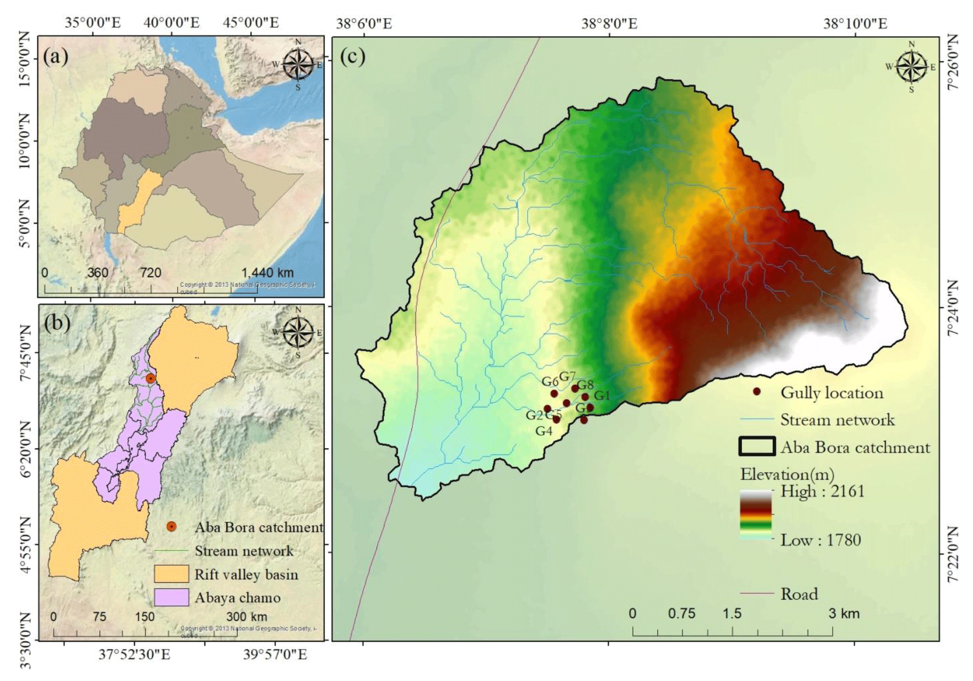
Figure 1Map of the study area: Aba-Bora watershed, Halaba, southern Ethiopia. (a) Rift Valley lakes basin within Ethiopia, (b) Abaya Chamo subbasin within Rift Valley lakes basin, (c) Aba Bora watershed. Source: authors' creation.
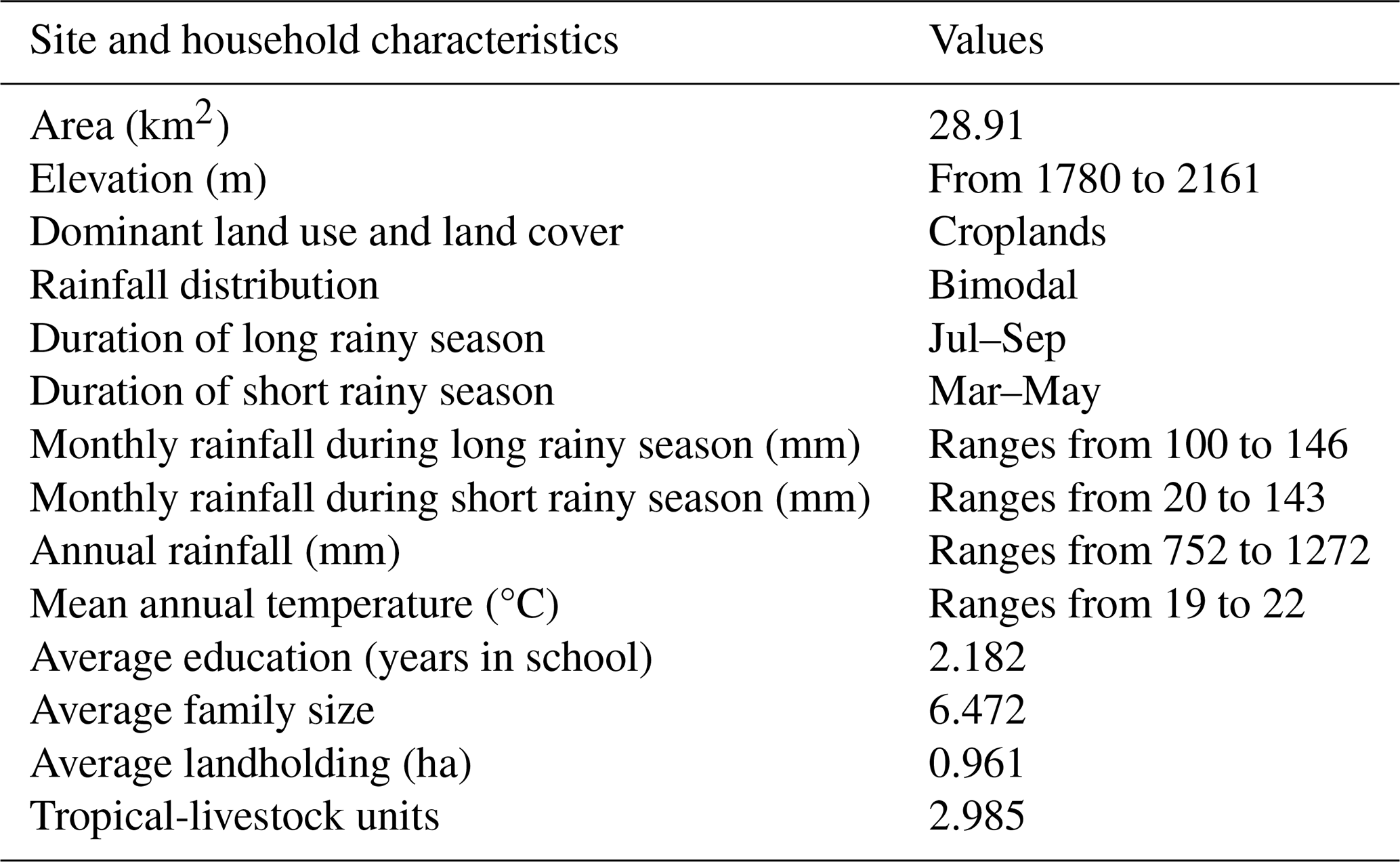
Table 1Selected characteristics of Aba-Bora watershed (Mekuria et al., 2023).
2.1 Study area
This study was conducted in Aba-Bora watershed, Halaba, southern Ethiopia (Fig. 1). Selected characteristics of the watershed are summarized in Table 1 (Mekuria et al., 2023). Households in the Aba-Bora watershed make their livelihood mainly from a subsistence mixed crop–livestock farming system (Mekuria et al., 2023). A number of households also engage in on-farm and non-farming activities, but agriculture and crop sale incomes account for over 80 % of household incomes (Mekuria et al., 2023).
Declining soil fertility, severe soil erosion, reduced access to surface and groundwater, and poor water quality are the main socio-economic and environmental challenges in the studied watershed (Sinore and Umer, 2021). In particular, gully erosion (Fig. 2) is one of the main causes of land degradation, manifested by deep gullies exacerbated by increased deforestation in the upstream areas (Mekuria et al., 2023), soils susceptible to soil erosion (Yakob et al., 2022), and a shift from livestock- to crop-based agriculture (Byg et al., 2017). The lack of low-cost gully rehabilitation technologies and the awareness required from local communities to address gullies at the early stage of gully initiation and formation have also contributed to the expansion of gullies (Addisie et al., 2017).
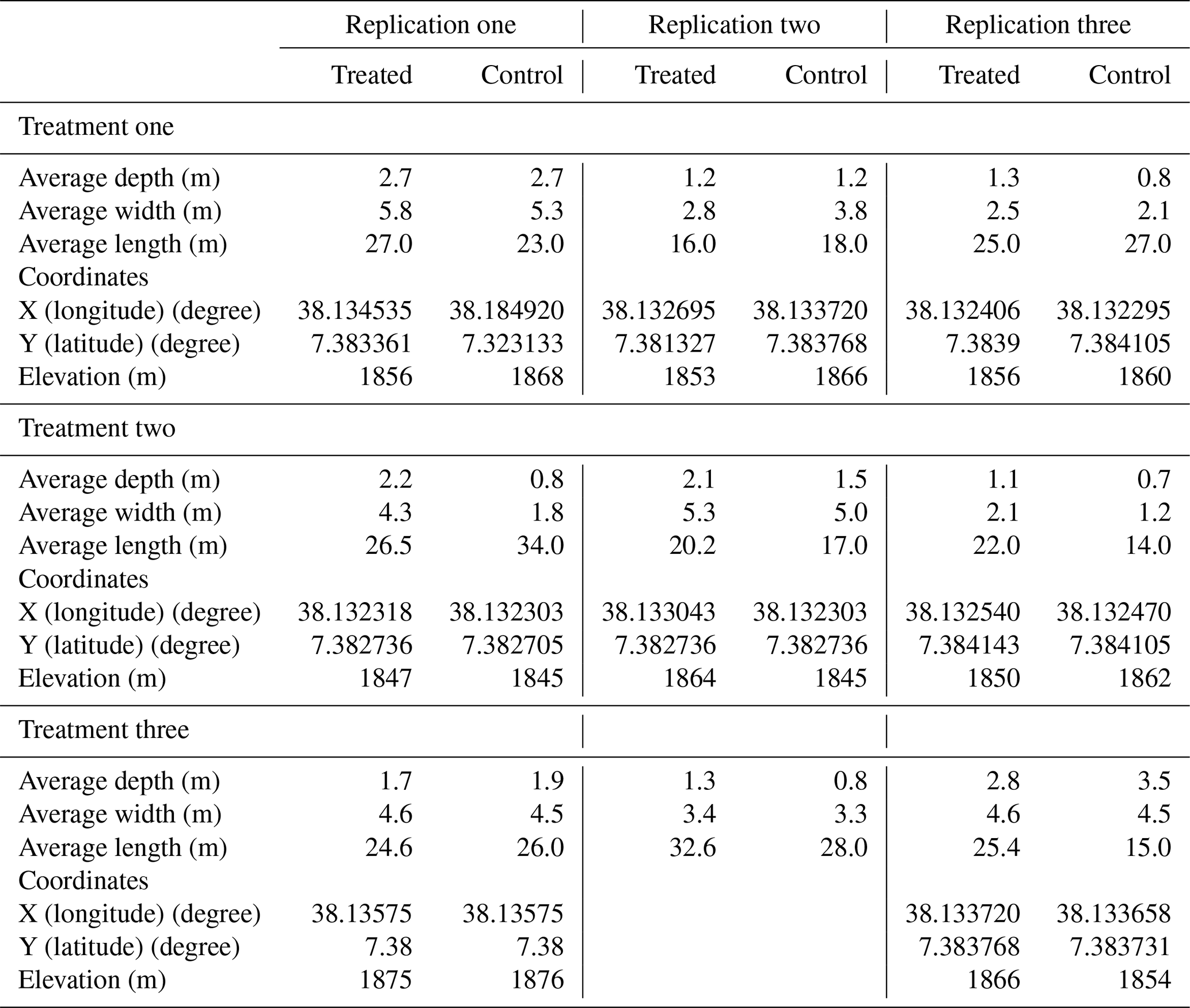
Table 2Dimensions of treated and control gullies prior to the establishment of on-farm trials.
2.2 Gully erosion study design and data collection
Nine paired gullies (i.e. treated and untreated) were selected (Table 2) from the mid-slope position (Fig. 1). They all had depths of less than 3 m to control the influence of gully size and location on the low-cost gully rehabilitation measures investigated. Moreover, paired plots had similar soil, topography, and land use and land cover, with spatial distributions of less than 2 ha of land area so that climatic variables, such as rainfall and temperature, were similar. The study considered three low-cost gully rehabilitation measures as treatments (Fig. 2), each replicated three times. The treatments were (1) regrading the gully head (45°) by establishing stone riprap (riprap treatment); (2) regrading the gully head and gully bank by establishing stone riprap at the gully head and planting grasses on the gully banks (riprap–grass-planting integration treatment); and (3) regrading the gully head and gully bank by establishing stone riprap at the gully head, planting grasses on the gully banks, and constructing small sandbag check-dams (riprap–grass-planting–check-dam integration treatment). The on-farm field experiment was established in 2021. In this study, low-cost gully rehabilitation measures refer to interventions that can be implemented within farmers' capacities or with limited external support.
In the established field experiments, the upward expansion of gully heads in the treated and control gullies was monitored at different intervals, after 4, 9, 12, 17, and 26 months. The upward expansion of gully heads was measured against pegs installed at 1 and 2 m from the gully head. The distance of a permanent reference point (i.e. big trees on the farm and close to the investigated gullies) from the 2 m peg was also measured in case it was removed by the upward expansion of the gully head with time. To estimate the volume and amount of soil loss during the period of investigation, the depth, width, and length of the upward-expanded part of gullies were measured at the beginning and end of the project period at 26 months. The soil loss from the upward expansion of gullies was calculated by multiplying the volume of soil by an approximate bulk density of 1.3 g cm−3. Erosion further down the gully was beyond the scope of our study.
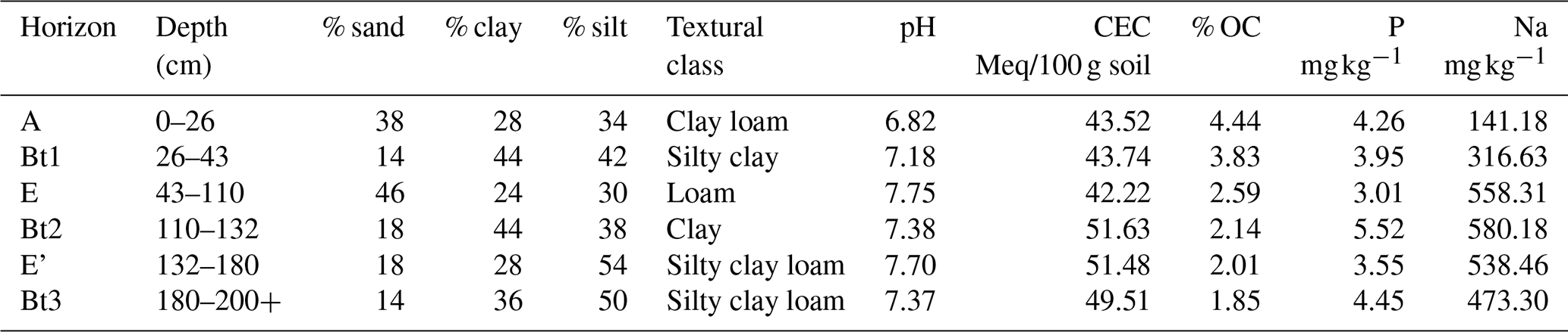
According to Yakob et al. (unpublished), the soil in the study area is made up of Luvisols, with an argic subsoil horizon containing more clay than in the topsoil and a high base saturation at 50–100 cm depth. Selected characteristics of the soil in the study area are summarized in Table 3.
2.3 Stakeholder engagement and qualitative data collection and analysis
Four different forms of stakeholder engagement and qualitative data collection were conducted: (i) field days, (ii) key-informant interviews involving experts, (iii) focus group discussions, and (iv) household surveys. Details of these activities are summarized below, with details provided in the Supplementary.
Field days. To promote knowledge and understanding of the experiments, a field day was organized in the kebeles where the on-farm trials were established. This was held in November 2022 in collaboration with the Southern Agricultural Research Institute (SARI) and district and zonal agricultural offices. Kebeles are typically localities containing around 500 households, with an administrative centre around which agricultural extension is typically organized. The field day focused on the demonstration of gully head treatments and gully bank stabilization, as well as incentives used to support the sustainable management of land resources. More than 55 participants, comprising farmers; extension agents; experts from district-, zonal-, and regional-level agricultural offices; and local administrative bodies, attended the field day to share ideas.
Key-informant interviews. Key-informant interviews were conducted to understand the system and to assess the drivers, pressures, states, and impacts of and responses to (DPSIR) gully erosion and to develop the conceptual DPSIR framework of the interventions for gully erosion and formation. The DPSIR approach was adopted as it has been widely deployed to provide a causal framework to link environmental and social processes (Kristensen, 2004). A total of 25 key informants consisting of 8 local practitioners (district and zonal agricultural offices), 10 knowledgeable farmers, 2 NGOs, 2 cooperatives, 2 civil societies or community-based organizations, and 1 local administrative body were selected. We used semi-structured questionnaires and checklists to gather data. The discussion points with key informants included the causes and severity of gully erosion, existing gully rehabilitation measures, the effectiveness of responses to address gully erosion, the management and allocation of natural resources, and the key changes following the implementation of gully rehabilitation measures. Knowledgeable farmers in this study were experienced in organizing and leading watershed management practices, members of community watershed teams, and early adopters.
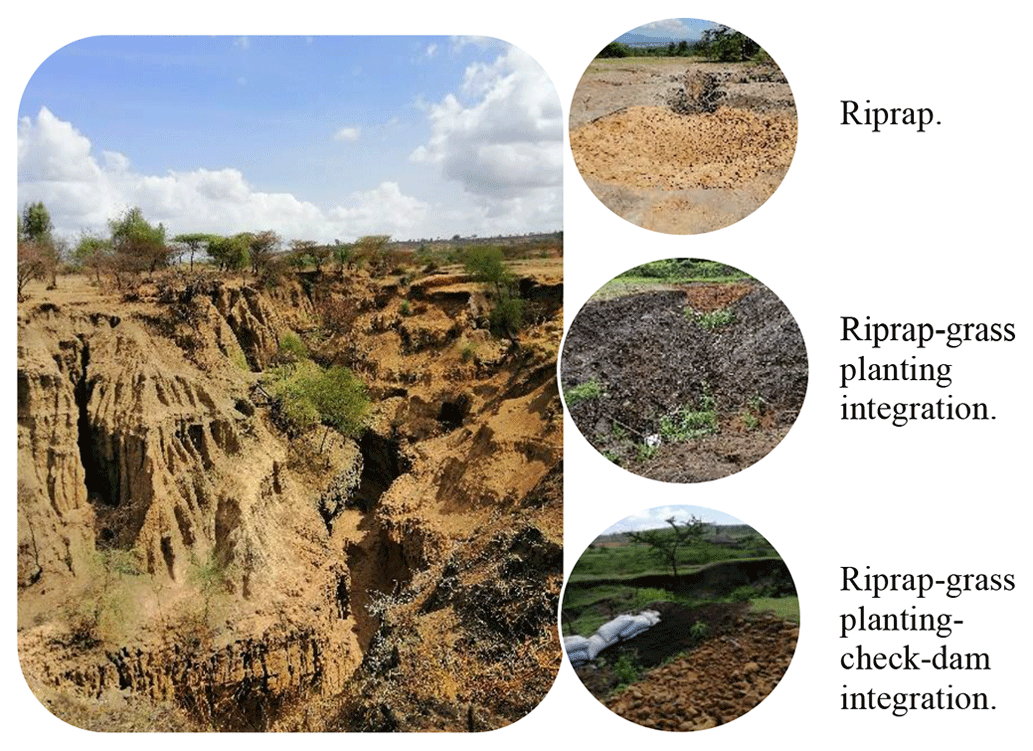
Figure 2Severe gully erosion in Aba-Bora and low-cost mitigation options. Picture credit @Wolde Mekuria.
Focus group discussions. Two focus group discussions (men and women separately) assessed the costs and benefits of five gully rehabilitation measures from the perspective of local communities. The assessed gully rehabilitation measures included both those in our field experiments and others commonly implemented locally, i.e. gully head treatment, gully reshaping and planting of grasses, loose-rock check-dams, vegetation log check-dams, and gabion check-dams. The focus groups first discussed the selected gully rehabilitation measures (i.e. the practices were presented using understandable descriptions in the local language and were confirmed by the participants), specifically the advantages and disadvantages from the perspective of the local communities. Next, the participants rated the importance of each identified advantage and disadvantage, giving scores of 3 points for the most important, 2 for those of intermediate importance, and 1 for the least important. Finally, the participants graded each practice or intervention as positive, negative, or neutral.
The qualitative data collected through key-informant interviews and focus group discussions were analysed using content analysis (Hsieh and Sannon, 2005; Bernard, 2006; Elo and Kyngas, 2008). For qualitative analyses, we developed a coding scheme based on the main thematic areas, including items such as drivers of gully erosion and formation, pressure on the natural resources, response of gully erosion, impacts of gully rehabilitation measures, and decision-making processes. These were coded manually. Deductive manual coding, which starts with a predetermined set of codes derived from the conceptual framework used in this study (i.e. the DPSIR framework), was then employed using codes such as the severity of gully erosion, types of drivers and impacts, and types of interventions. During the coding process, more codes were added when new issues emerged from the textual data. In addition, codes were merged, removed, or modified to avoid repetition and to resolve disagreements between codes.
Household surveys. In addition, two household surveys were conducted in 2021 and 2023 in the Aba-Bora and nearby Guder watersheds in localities where land was judged to be highly degraded with large gullies present. This included the kebele where the on-farm field experiment and focus group discussions took place. In 2021, data were collected from 522 households (including 123 from the kebele where the on-farm field experiment took place). In 2023, a follow-up survey collected data from 500 households, of which 451 could be identified as being the same respondents as previously (including 114 where the on-farm field experiment took place). The sample represented a random sample of households drawn from lists provided by each kebele administration after stratification based on wealth and gender status. The data were collected during February and March in 2021 and 2023 using a team of enumerators employing computer tablets, with the questionnaires being available in both English and the local language Amharic (S1 in the Supplement).
The 2021 and 2023 household surveys included a series of questions exploring respondents' knowledge, attitudes, and behaviour with respect to land degradation and gullies. The respondents' data were compared in terms of “treated” and “non-treated” to explore the potential impact of the on-farm experiment. Where identical questions were asked in both the 2021 and 2023 surveys, the impact of the on-farm experiment was examined using a panel difference-in-difference (DD) approach, controlling for individual fixed effects and a common trend (Glewwe and Todd, 2022; see also S1 and S2 in the Supplement). The DD model compares changes in the indicator over time. Therefore, the DD model compares trends in the control group from before and after the project to trends in the treatment group. The double difference then refers to the difference over time (the first difference) and the difference between the control and treatment (the second difference). If the trends are statistically significantly greater for the treatment group (in a statistical sense), this suggests that the intervention had an impact. Thus, the DD estimator combines cross-sectional and over-time variation to correct for differences between groups when the treatment and controls start at different levels. Sections S1 and S2 provide further details of the questions asked and the DD method.
The 2023 survey also included several more specific questions (items) on gullies, drawing on the nature of the on-farm experiments, to explore respondents' knowledge, understanding, perceived capacity to act, and behaviour with respect to land degradation and gullies. Knowledge, understanding, and perceived capacity to act can be conceived as latent (unobservable) values but where different survey questions (scales or items) can be designed to capture these underlying unobserved values (see S1 and S2).
The specific approach applied here draws on the marketing literature to consider both the recall and recognition of different interventions (Boshoff and Gerber, 2008; Macdonald and Sharp, 2010; Hoyer and Brown, 1990). This approach has also been used to explore how knowledge and understanding may relate to attitudes about nature conservation (Pearson et al., 2022; Veríssimo et al., 2017; Schlegel and Rupf, 2010). In line with this approach, the respondents were first asked in an open-ended-question format to name three interventions or activities that they thought were important in reducing land degradation. The answers were then grouped and weighted to provide an awareness score ranging from 0 for completely unaware to 3 for very aware (Boshoff and Gerber, 2008). The second set of questions explored the extent to which the respondents have knowledge of specific interventions. Here, the respondents were shown pictures of different interventions, where the first two (gully head treatment and reshaping gully banks) could be linked directly to treatments one and two implemented in the on-farm experiments, while the third and fourth interventions shown could be more loosely related to treatment three (Table 2). First, to explore respondents' recognition and understanding, they were asked about their view of the effectiveness of the measures. Second, to explore their perception of their capacity to implement the measures, they were asked whether they could undertake these measures on their own or if they would need the help of neighbours or full community mobilization (see S1 and S2 for the specific question formats used). The original five-point answers were aggregated into the three categories reported on (on their own, with neighbours, community mobilization). The reliability with which the various sets of questions (items) captured the same underlying latent variable (knowledge, understanding, and capacity to act) was tested using Cronbach's alpha. Cronbach's alpha is an internal-consistency method of reliability that shows a measure's homogeneity and that occurs when different attempts at measuring a concept converge on the same result (Churchill, 1979). The coefficient alpha ranges from 0 to 1, and a coefficient alpha of 0.7 or greater is considered to be an acceptable measure of reliability (Taber, 2018).
The more specific questions on gullies asked in 2023 only were analysed using a simple comparison between the treated and non-treated kebeles. This included analysing the respondents' capacities to implement the measures by estimating a simple multinomial logit to model the probability that a respondent felt interventions could be implemented by them on their own, with the help of neighbours, or by means of community mobilization (S2).
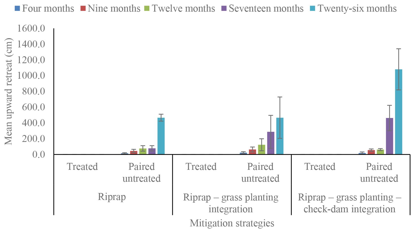
Figure 3The mean upward expansion of gully heads in the treated and paired untreated gullies as described in the study design. The paired untreated gullies accounted for their spatial distribution, where a grouped control site would introduce variability due to slight changes in climate or soils. For all treated gullies, the values for the upward expansion of gully heads was negligible.
3.1 Gully head upward expansion and soil loss
Regardless of the mitigation practice, all treated gullies had negligible upward expansion (Fig. 3). This contrasted with untreated gullies that expanded by a few centimetres after 4 months, increasing up to several metres after 26 months, ranging from 19 (± 4.3) to 671 (± 354) cm. Assuming a bulk density of 1.2–1.5 g cm−3, the estimated soil loss due to the upward expansion of gully heads in the untreated gullies ranged from 2.8 to 20.2 t, with a mean value of 11.0 (± 5.9) t, over 26 months. This value was zero in the treated gullies.
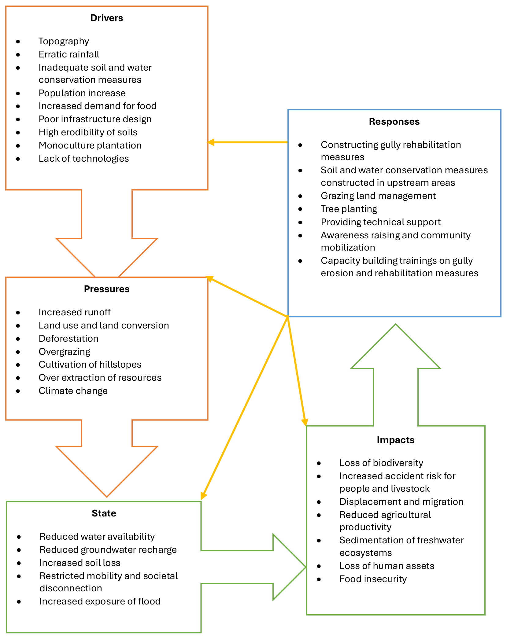
Figure 4Conceptual framework of drivers, pressures, states, impacts, and responses for gully erosion and formation taken from key-informant interviews. The yellow arrows in the figure show that a response which is the result of an undesired impact can affect any part of the chain between driving forces and impacts.
3.2 The drivers, pressures, states, impacts, and responses of gully erosion and formation
Good knowledge of gully initiation processes was demonstrated by key informants. They indicated that gullies usually initiated in the upstream areas and took the form of rill erosion. Over time, they recognized that rills got longer and deeper in the mid- and foot-slope landscape positions to form gullies. They remarked that the density and depth of gullies usually increased from mid-slope to foot-slope positions but that gullies were unevenly distributed within the watershed, with a few locations eroding differently along the slope. The key informants identified multiple human-induced, natural, and climatic drivers of gully erosion and formation (Fig. 4). About 80 % of the key informants characterized the severity of gully erosion as very severe, while the rest characterized gully erosion as severe, causing environmental, social, and economic impacts. Gully erosion was considered to cause both long- and short-term negative impacts that affect the livelihood of local communities (Fig. 4). The key informants also mentioned multiple initiatives implemented in the watershed to address gully erosion. These initiatives covered multiple dimensions: capacity building, providing technical support, and implementing diverse interventions or measures (Fig. 4). The commonly implemented gully rehabilitation measures included check-dams (loose-rock, sandbag, and gabion check-dams), biological measures such as planting multipurpose tree species and grasses on gully banks, and gully head treatments.
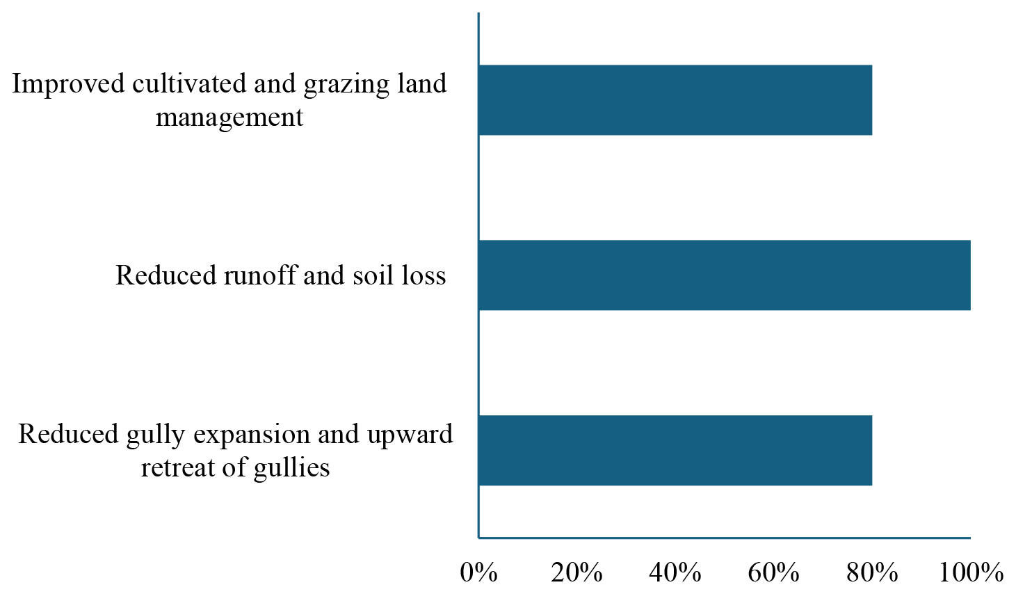
Figure 5Mechanisms identified by key informants through which gully rehabilitation measures restore degraded lands. Numbers indicate the proportion of key informants that mentioned the specific mechanisms. The sum of numbers is greater than 100 % as a respondent can mention multiple ways.
The majority (90 %) of key informants indicated that the implemented gully rehabilitation activities were successful but that they did not cover all affected areas and were inadequate compared with the severity of the problem. They further elaborated that the rehabilitation measures not only reduced soil erosion but could also convert degraded lands into productive lands. The restoration of degraded lands by gully rehabilitation included reduced expansion and upward expansion of gullies, reduced runoff and soil loss, and improved cultivated- and grazing-land management (Fig. 5). Furthermore, key informants suggested that gully rehabilitation measures enabled farmers to diversify their crops to grow cereals, vegetables, and fruit. This was mainly attributed to reduced soil loss that resulted in enhanced soil nutrient retention and sometimes the accumulation of sediments behind check-dams. One of the key informants elaborated upon this as follows: “Farmers who migrated have started to come back and grow cash crops such as khat, vegetables, and maize due to the improvement of soil fertility. Particularly, this is observed at the downstream areas of each treated gullies.”
In relation to the contribution of gully rehabilitation measures to livestock production, one of the key informants stated the following: “Decades ago, households used to have more than 30 livestock on average; however, the expansion of overgrazing and shortage of livestock feed forced them to reduce the number of livestock. Following the recent community-based watershed development activities, including gully rehabilitation works, the number of livestock per household is increasing due to increased production and availability of livestock feed from restored areas and gullies.”
The ongoing rehabilitation activities were also key to establishing community awareness about the negative consequences of gully erosion and the need for collective action to control gully erosion. The key informants mentioned that effective implementation and sustainability of gully rehabilitation measures required continuous technical support, particularly if more challenging biological measures were adopted. However, a few (10 %) of the key informants stressed that it was hard to judge the success of interventions compared to the challenges of gully erosion. The majority (90 %) of key informants also indicated that the efforts were not adequate compared with the severity of the problem.
The key-informant interview results suggested that gully erosion can be addressed by individual or collective actions. Particularly, the respondents mentioned that small gullies (of less than 3 m depth), such as those assessed in our field research, can be rehabilitated using locally available materials and capacities. However, once the gullies get large and deep, it is beyond the capacity of local communities to rehabilitate them. The decisions on the planning, design, and implementation of gully rehabilitation measures combined both bottom-up and top-down approaches. At the local or kebele level, a community watershed team was the key decision-maker, dictating intervention areas, types of interventions, and the labour and material contributions of communities. However, there were also cases where the regional bureau and zonal departments allocated a quota (e.g. types and quantities of interventions) to each district and kebele. The regional and zonal departments and NGOs were also involved in providing technical, material, and financial support.
Community-level decisions in relation to gully rehabilitation measures usually depend on the contribution of free labour and locally available materials. Our survey found that this extended beyond building materials, such as stone and wood, to the equipment and tools required for construction. In line with this, the community watershed team worked closely with kebele- and district-level experts to decide on community mobilization. This determined who participated, the types of interventions, and the use of material and labour. There were also household-level decisions that could be implemented by individual households, such as taking measures to prevent runoff from entering their houses and farmlands. On and around their farmlands, these usually involved constructing wooden or vegetation check-dams, water-harvesting structures, and bunds. Some individuals identified by the key informants were aware of gully erosion and took their own actions around the homestead by planting trees or by means of gully head treatment.
Cooperative efforts had also been implemented to effectively manage gully rehabilitation measures, including informal platforms established by Idir (self-support groups) and Iqub (voluntary cooperatives). Some actions were instigated by bylaws and so worked closely with formal institutions to enforce laws and to protect interventions from free-riders (i.e. those who seek benefits while violating existing rules and regulations). The cooperative efforts had incentive mechanisms, such as engaging landless young people and women in income-generating activities through providing beehives, sheep, and oxen. Such incentive mechanisms strengthened the protection of land management practices, including gully rehabilitation measures, in a way that could be sustained and beneficial to farmers. Furthermore, the use of locally available materials and the involvement of elders and religious institutions in awareness creation campaigns were effective strategies to sustainably implement gully rehabilitation measures.
The key informants mentioned multiple sources of information. A majority (40 %–60 %) of the respondents indicated that the key sources of information were the ongoing gully rehabilitation activities, personal experience, and observation. The main limitation of gully rehabilitation measures constructed using locally available materials was the short lifespan of physical interventions, such as sandbag or log check-dams. However, when physical interventions were combined with vegetation, the longevity of the intervention improved. Our findings suggest that most of the gully rehabilitation measures were well received by the communities, with the only concern being a temporary loss of access to their land or resources during construction. Out-scaling and/or wider implementation of gully rehabilitation measures were constrained by a shortage of personal tools (mentioned by 30 % of the respondents), limited access to inputs and raw materials (30 %), increasing prices of inputs (e.g. gabion wires, 60 %), high labour demands (10 %), technical requirements (30 %), and limited sources of finance (10 %).
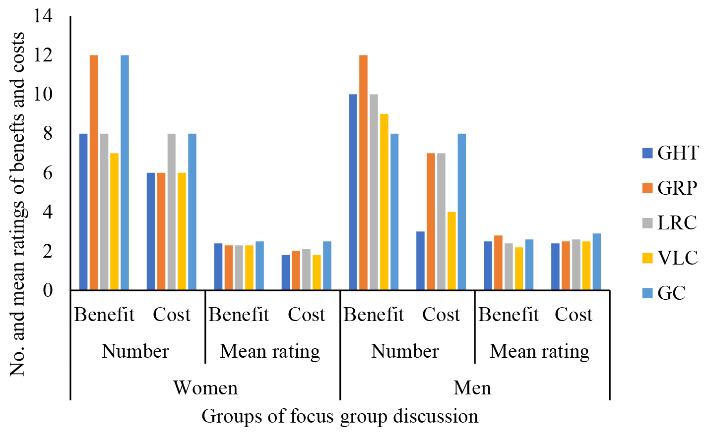
Figure 6The number and ratings of the importance of benefit and cost factors from the perspective of the local communities. GHT – gully head treatment, GRP – gully reshaping and planting, LRC – loose-rock check-dam, VLC – vegetation log check-dam, GC – gabion check-dam. The values indicate the aggregate numbers of the benefits and costs of all three categories (environmental, economic, and social).
3.3 Costs and benefits of gully rehabilitation measures from the perspective of local communities
Participants of focus group discussions, representing men and women separately, identified 24 benefits (or advantages) and 17 costs (or disadvantages) of the five gully rehabilitation measures assessed in the Aba-Bora watershed (Tables S1 and S2 in the Supplement). Across both focus groups, the number of benefits identified for most of the gully rehabilitation measures outweighed the costs (Fig. 6). There were gender differences in the perceived costs and benefits. While female groups identified equal numbers of costs and benefits for loose-rock check-dams, male groups felt the benefits were greater than the costs. An opposite trend between genders was observed for gabion check-dams (Fig. 6), where men indicated higher costs than women. The groups of both women and men identified more benefits for gully reshaping and planting, indicating that there was a consensus among the two groups regarding the benefits of this intervention. Both groups identified comparable numbers of benefits and costs.
The benefits were diverse (Table S1) and covered environmental (e.g. conservation and increased access to water, improved soil fertility, and reduced runoff and soil erosion), economic (e.g. increased agricultural production, reduced farmland loss, and increased availability of livestock feed), and social (e.g. movement of people and livestock, reduced damage by floods, and knowledge exchange) categories. There were 24 identified benefit factors, but women were the only respondents to identify (i) the use of locally available materials, (ii) conserving and increasing access to water, and (iii) increased access to productive land. On the other hand, the men's groups listed eight benefits that were not identified by the women's groups. These were (i) increased income, (ii) increased access to diverse food, (iii) improved appearance of the landscape, (iv) a reduction in damage caused by floods, (v) regulation of micro-climate, (vi) ease of constructing the interventions, (vii) durability of the interventions, and (viii) serving as a learning site (Table S1). The participants also identified several costs of the assessed interventions or practices that were environmental (e.g. lack of effectiveness in reducing soil erosion and runoff), economic (e.g. high labour demand, cost, shortage of local available inputs), or social (e.g. demand for skilled manpower, technical support) (Table S2).
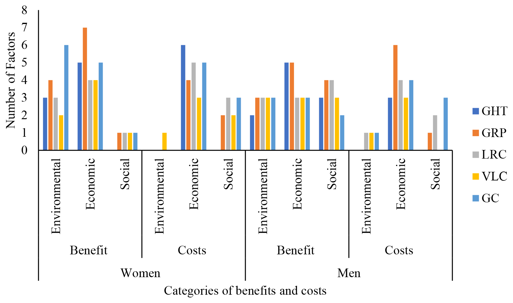
Figure 7The number of benefit and cost factors under each of the categories of benefits and costs. For abbreviations, refer to Fig. 6.
Across both groups, the number of environmental benefits identified by the participants was larger than the respective environmental costs (Fig. 7). Whereas female groups identified more social costs than benefits, male groups had an opposite opinion (Fig. 7). Across both groups, the benefits of the assessed gully rehabilitation measures mainly related to the categories of environmental and economic benefits, whereas the costs largely related to the categories of economic and social costs (Fig. 7).
The local surveys suggested that the benefits outweighed the costs for most of the interventions (Fig. 6). The ratings of the importance of benefits assigned by women's groups across all the interventions varied between 2.3 and 2.5 (i.e. the rating is out of 3, and 3 represents high importance, 2 represents medium importance, and 1 represents low importance), with a mean value of 2.4, while the ratings of the costs ranged from 1.8 to 2.5, with a mean value of 2.0. The ratings of benefits assigned by men's groups varied between 2.2 and 2.8, with a mean value of 2.5, while the ratings of the costs ranged from 2.4 to 2.9, with a mean value of 2.6.
Table 4Local communities' overall assessment of gully rehabilitation measures.
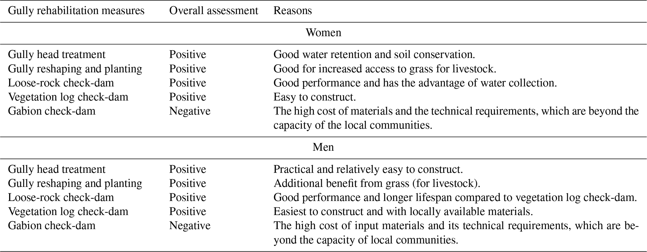
Apart from gabion check-dams, all other gully rehabilitation measures assessed were evaluated as positive (Table 4). The local communities considered environmental and economic factors more than social factors in their overall assessment of the gully rehabilitation measures (Table 4).
Table 5Impact of on-farm field experiment – difference-in-difference estimates.
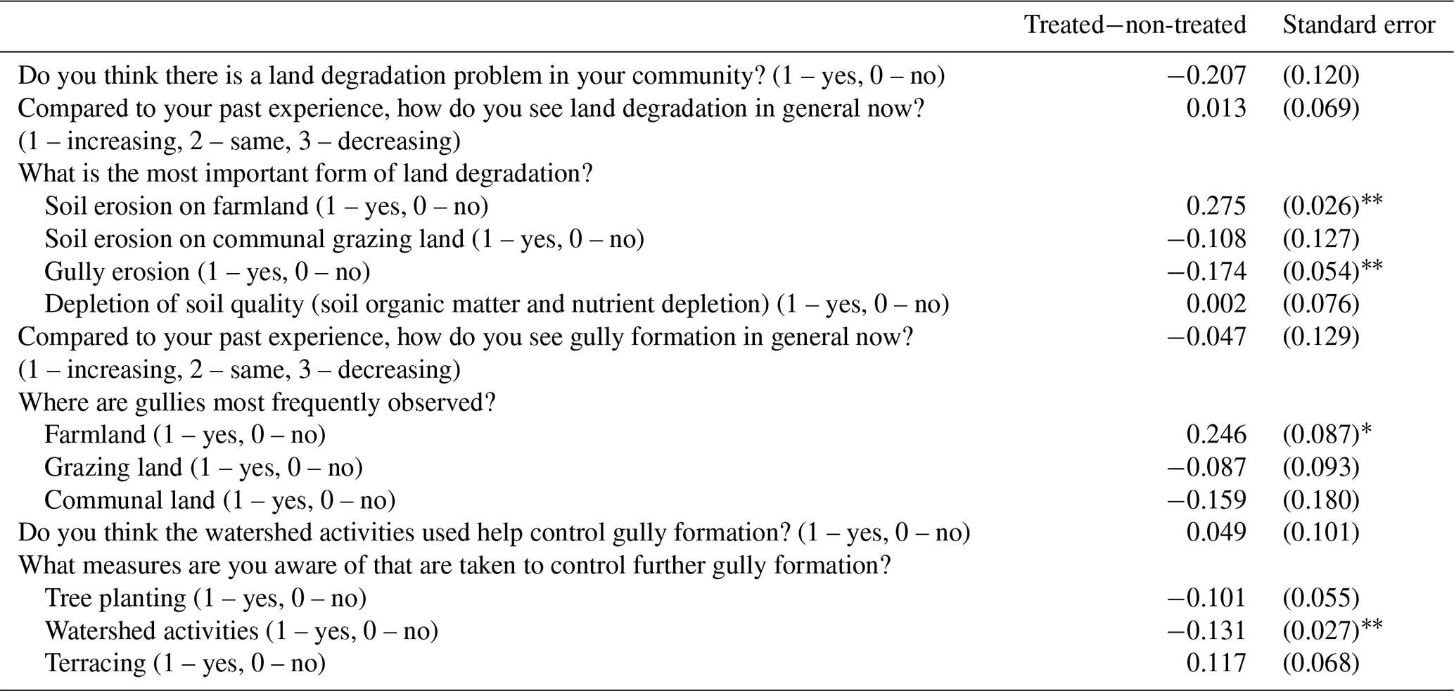
Note that the treated−non-treated estimates represent the estimated coefficient of the variable for the kebele from a simple fixed-effect difference-in-difference estimation using the matched 2021 and 2023 sample. The standard errors allow for clustering at the kebele level. ∗ and indicate differences which are statistically significantly different at 10 % (i.e. 90 % confidence interval) and 5 % (95 % confidence interval), respectively. There were 522 respondents in 2021 and 500 respondents in 2023.
3.4 Local communities' knowledge, attitudes, and behaviour
The knowledge and awareness of gullies exhibited by the > 500 respondents in the household surveys are summarized in Table 5. The data describe typical attitudes about land degradation and the respondents' views on the extent to which gullies have advanced between experimental locations with and without interventions in place. As far as the authors are aware, this represents the first evidence of this type, which explores whether local demonstrations of gully treatment effectiveness have an impact on local farmers' knowledge, awareness, and behaviour. In response to a general question about the extent of land degradation and gully erosion, there was no evidence of a change in attitudes before and after the experiments took place. However, in the treatment areas, there was some evidence of changes in perceptions regarding the extent and most important types of soil erosion and where gully erosion occurs, with a greater perception that the main impacts are focussed on farmland.
Table 6Impact of on-farm field experiment. Differences in recall, recognition, and capacity to deal with gullies across treated and non-treated areas (2023 survey).
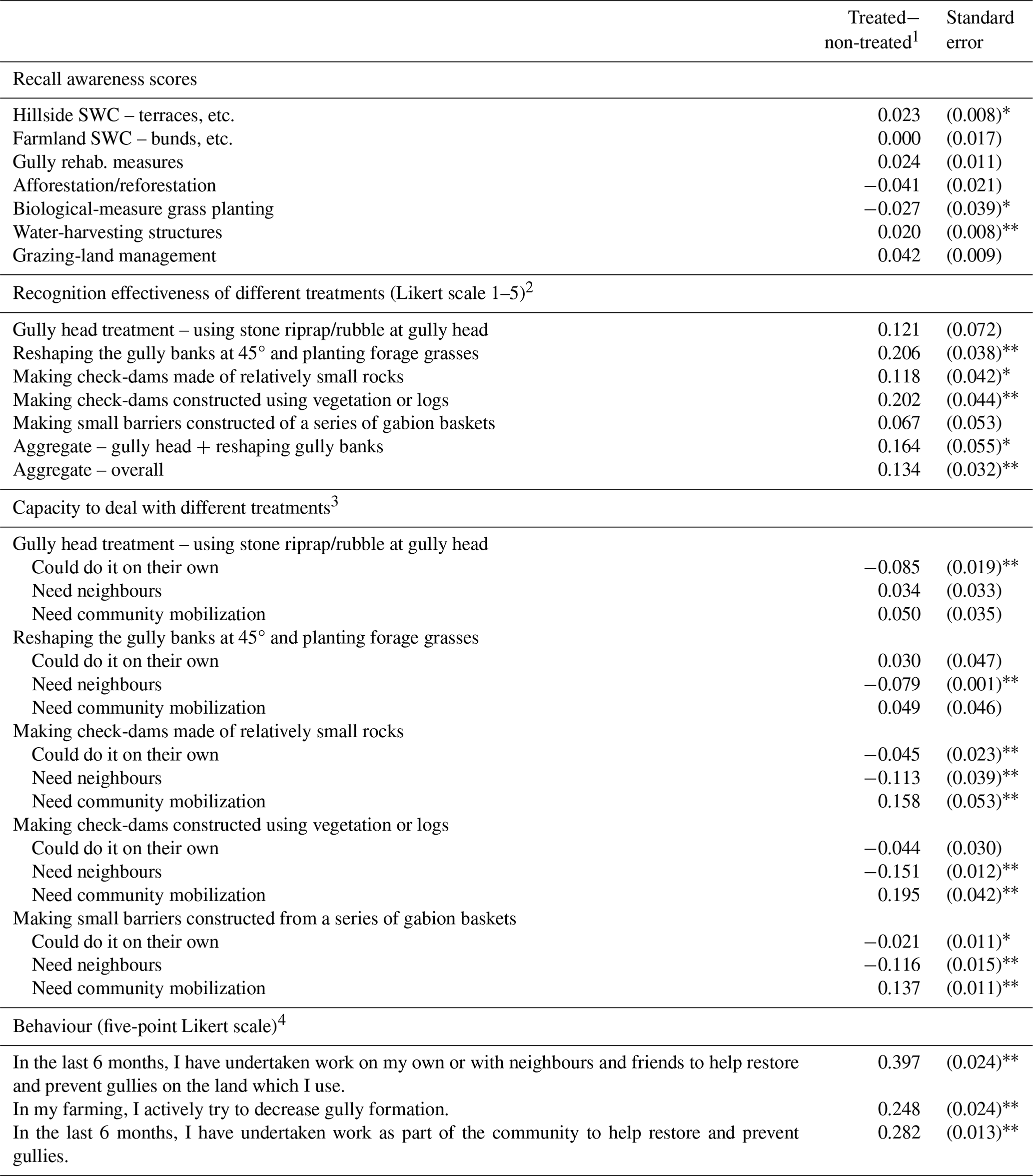
1 For each variable, the reported coefficients represent the average difference in responses between the treated and non-treated areas. 2 Scale 1 – not at all effective, 2 – not really effective, 3 – somewhat effective, 4 – effective, 5 – very effective. 3 These estimates represent the marginal effect of being in the treated area on the probability of selecting one of the options of “could do it on their own”, “need neighbours”, or “need community mobilization”. The underlying coefficients for this calculation are estimated using a simple multinomial logit with treatment as the only covariate. 4 Scale 1 – no, not at all; 2 – yes, once or twice; 3 – yes, occasionally (more than twice); 4 – yes, regularly (at least once a month); 5 – yes, very often (at least once a week). The standard errors allow for clustering at the kebele level. ∗ and indicate differences which are statistically significantly different at 10 % and 5 %, respectively. Data based on 500 responses. SWC – soil water conservation.
Table 6 reports the estimates using questions specifically asked in the 2023 survey and represents the difference between the mean in the treated and non-treated areas. Here, the recall questions consider whether respondents were aware of and able to recollect different land degradation measures from a general cue (i.e. from the list of land restoration measures presented to the respondents). The differences in the scores between the treated and non-treated areas are reported in the first panel of Table 6. Some differences in the levels of recognition were apparent, such as greater recognition of mountain measures such as terracing, high recognition but with weak evidence (p value of 0.12) of gully measures, and lower recognition of grassland management measures.
Through these household surveys, we confirmed our hypothesis that demonstrating interventions through field studies influenced the knowledge and understanding of similar gully treatments among respondents. The average measures of effectiveness were all higher for those living where demonstration gullies were established, especially for the gully shaping and check-dams. Testing the set of questions (items) using Cronbach's alpha confirms that they can be interpreted as capturing a single underlying characteristic, i.e. knowledge of the gully treatments (alpha 0.74). Testing the averaging aggregate score also suggests that there was a statistically significant difference between the knowledge and understanding of these measures in the area where the on-field experiments took place.
The last panel in Table 6 reports the results from the multinomial logit estimation applied to the questions (items) regarding an individual's capacity to deal with different gully treatments (see S2 in the Supplement). The estimates reported represent the marginal effects of being in the treated area on the probability of selecting a particular option. For the gully head treatment, for example, respondents in the treatment area had a 0.085 lower probability of selecting “could do this alone” than those respondents in the areas where no experiments took place. Overall, there was evidence that the respondents in the treated area have a different view of the resources required to undertake the measures. The probability that the respondents would choose the option “could do it alone” or “need neighbours” was lower in the treatment areas in all cases, except for the reshaping of gully banks treatment, and the probability was higher for the option “need community mobilization”, with the latter underlying difference being statistically significant (at 5 %) in three out of the five different treatments. Hence, the respondents appeared to be generally more pessimistic about their ability to undertake this alone or with neighbours. This emphasizes that increased knowledge of gully treatments may mean farmers could become aware of the challenges required to implement treatments.
The final set of questions in the last panel for Table 6 assessed possible differences in behaviours related to gullies between the samples (i.e. household survey respondents) in the areas with and without the on-farm experiments. Here, there are statistically significant differences that are consistent with greater efforts being made to undertake work to reduce gullies in the treated area. The averages for all questions were statistically significantly higher (p < 0.05) for the respondents in the treatment area; e.g. the average was 0.397 points higher for questions involving individual work and work with neighbours and friends and 0.248 points higher for questions around farmers actively trying to decrease gully formation. This is consistent with the hypothesis that the on-farm experiments and field day demonstrations have positively affected farmers' behaviours (or intentions) in acting to help restore and prevent gullies (despite their apparent greater pessimism about their capacity to do so alone).
The zero upward expansion of gully heads in the treated gullies reflects the effectiveness of interventions in halting the upward expansion of gully heads and in reducing soil loss. As all investigated gullies were established in sites exhibiting similar site and climatic characteristics, good reproducibility of the impacts was evident for this locality (Fig. 1). The effectiveness of gully head rehabilitation measures has been observed in other research based in Ethiopia (e.g. Ayele et al., 2016; Asfawesen et al., 2021). These studies indicated that the key role of gully rehabilitation measures in reducing runoff and soil loss was attributed to the capacity of the measures to reduce the speed of runoff, retain soils, and facilitate the growth of grasses in the retained soil. The contribution of check-dams to cultivated- and grazing-land management was mainly through converting degraded areas into productive land or reducing degradation (i.e. increasing access to or the availability of productive land) and improving the production of livestock feed and crops. Despite the positive effects of interventions to halt gully erosion, the key informants believe that the efforts were not adequate. This argument could be attributed to the extent and severity of gully erosion and to the limited out-scaling of activities. Clearly, local measures are accessible to farmers provided that mitigation takes place early before gullies grow too large.
However, addressing the key constraints of out-scaling gully rehabilitation measures is required to promote a wider adoption of interventions and long-term sustainability. This, in turn, implies the need to focus on context-specific technologies that are socially, economically, and environmentally feasible. For example, the increasing prices of gabion wires and the limited access to financing suggest that interventions or technologies for gully rehabilitation should use limited external inputs or be designed based on local knowledge and available local materials. The results also suggest that beginning gully reclamation at an early stage is important as reclaiming big gullies with other measures, such as loose-rock and gabion check-dams, is costly and difficult for smallholder farmers to manage considering their financial and technical capacities. In line with this, a study by Addisie et al. (2018) demonstrated that stopping the uphill advancement of gully heads by reclaiming gullies at an early stage of their formation and development (i.e. while they are shallow) is effective and less costly than reclaiming a bigger gully and can easily be managed by local communities. A study by Nicholson et al. (2015) suggested that the planning, design, and implementation of gully rehabilitation measures can be improved through the meaningful participation of local communities and co-creation of knowledge.
Differences between men and women in the perceived costs and benefits of gully rehabilitation measures (e.g. men attached higher costs to gabion check-dams than women) (Fig. 6) could be attributed to differences in their responsibilities in managing financial matters. In the study area, men usually took more responsibility in managing financial resources, which could make them more sensitive to the cost of materials. This implies that implementing interventions needs to consider the perceptions of the benefit factors that vary between the different groups of a community. This indicates the need for inclusive planning, design, and implementation of gully rehabilitation measures to take diverse opinions into account and to ensure sustainability. The results also suggest that different groups appreciate different benefits depending on experience and responsibilities. For example, improvements in access to and availability of water are more important for women than men as women are usually responsible for water collection.
The results also show that generating short-term economic benefits that are easily demonstrated is key to sustaining the assessed gully rehabilitation measures even though associated tangible non-economic benefits and ecosystem services are appreciated. The negative overall assessment of gabion check-dams by the local communities was mainly attributed to the high cost of input materials and the technical requirements, which were often beyond the capacity of local communities or farmers.
The gully erosion interventions deployed in this study are low-cost and practical for application in any region. Because the tested gully rehabilitation measures mainly use local materials and require limited technical and financial inputs, they were socially acceptable and could be implemented within the farmers' capacity. By combining the understanding of impacts on people with the understanding of environmental benefits, best practices that are most likely to be deployed and maintained have been identified. Further research in other regions will disentangle the global significance, but we found good agreement between the effectiveness of interventions in the Halaba district and what has been observed in studies exploring similar interventions in other regions. For example, a study in the Ethiopian highlands demonstrated that investment in low-cost gully rehabilitation measures can be an economically viable proposition (Yitbarek et al., 2012). The study further suggested that stakeholders involved in gully rehabilitation should continue to invest in appropriate techniques of gully rehabilitation and management to ensure continued benefits from rehabilitated gullies and use of surrounding farmlands. In a study in Pakistan, Hussain et al. (2022) also suggested that using gully rehabilitation technologies that are low-cost and easy to implement is key for wider adoption. Communities have a strong desire to act to improve their farming livelihoods, with an appreciation of environmental benefits too. Effective policy development, therefore, should focus on small-scale, cost-effective interventions over more costly systems, such as gabion baskets that are beyond the means of local communities.
The results suggest that the tested low-cost gully rehabilitation measures were effective and are viable options to mitigate the upward expansion of gully heads, thereby significantly reducing soil loss. Farmers also indicated that the implemented gully rehabilitation measures were successful, though out-scaling and/or wider implementation of these gully rehabilitation measures were constrained by diverse social, economic, and environmental challenges. However, this could be addressed by context-specific technologies that are feasible to implement. Introducing incentive mechanisms to motivate communities to participate in gully rehabilitation activities is also key in strengthening the protection of gully rehabilitation measures so that the potential benefits are sustained. Furthermore, as the benefit factors of an intervention cannot be the same for different groups of a community, it is crucial to have inclusive planning, design, and implementation of gully rehabilitation measures and to take diverse opinions into account.
The approach used in this study (i.e. the integration of on-farm field experiments with socio-economic studies and field demonstration) influenced the knowledge and understanding of local communities regarding available low-cost gully rehabilitation measures and their physical, natural, and human assets, as well as the time required for interventions. Specifically, there was clear evidence of greater efforts being made in undertaking work to reduce gullies in areas where mitigation measures had been implemented, suggesting that the on-farm experiments and field day demonstrations had empowered farmers to act despite their greater pessimism about their capacity to do so. In addition, farmer participation in our investigation of gully mitigation strategies supported the selection of the most effective, acceptable, and practical interventions from the perspective of local communities. Communities have a strong desire to act to improve their farming livelihood, with an appreciation of environmental benefits too. Effective policy development, therefore, should focus on small-scale, cost-effective interventions as over-engineered systems, such as gabion baskets, are beyond the capacity of local communities.
We used and analyzed all the primary data and reported them in the paper. Some primary data (unanalyzed) can be shared upon request.
The supplement related to this article is available online at: https://doi.org/10.5194/soil-10-637-2024-supplement.
WM: writing (original draft), data collection, analysis, investigation, visualization, methodology. EP: writing (original draft), data analysis, conceptualization, supervision, validation. GY: data collection, writing (review and editing). DT: data collection, analysis, review. AM: data collection, analysis, review. YT: data collection, analysis, writing (original draft). DM: data collection, analysis, review. CG: data analysis, conceptualization. PDH: writing (review and editing), conceptualization, validation. JS: writing (review and editing), conceptualization, validation.
At least one of the (co-)authors is a member of the editorial board of SOIL. The peer-review process was guided by an independent editor, and the authors also have no other competing interests to declare.
The University of Aberdeen submitted ethics application for using human subject and awarded certificate from the university.
Publisher's note: Copernicus Publications remains neutral with regard to jurisdictional claims made in the text, published maps, institutional affiliations, or any other geographical representation in this paper. While Copernicus Publications makes every effort to include appropriate place names, the final responsibility lies with the authors.
This work was supported by the Economic and Social Research Council grant awarded to the University of Aberdeen (grant no. ES/T003073/1).
This research has been supported by the Economic and Social Research Council (grant no. ES/T003073/1.).
This paper was edited by Estela Nadal Romero and reviewed by Christopher Shepard and one anonymous referee.
Addisie, M. B., Ayele, G. K., Gessess, A. A., Tilahun, S. A., Zegeye, A. D., Moges, M. M., Schmitter, P., Langendoen, E. J., and Steenhuis, T. S.: Gully head retreat in the sub-humid Ethiopian highlands: the Ene-Chilala catchment, Land Degrad. Dev., 28, 1579–1588, https://doi.org/10.1002/ldr.2688, 2017.
Addisie, M. B., Langendoen, E. J., Aynalem, D. W., Ayele, G. K., Tilahun, S. A., Schmitter, P., Mekuria, W., Moges, M. M., and Steenhuis, T. S.: Assessment of practices for controlling shallow valley-bottom gullies in the sub-Humid Ethiopian Highlands, Water, 10, 389, https://doi.org/10.3390/w10040389, 2018.
Adimas, N., Mekonnen, M., Tsegaye, D., and Senamaw, A.: Gully Erosion and Effectiveness of Its Treatment Measures, Upper Abay Basin, in the Northwest Highlands of Ethiopia, in: Nile and Grand Ethiopian Renaissance Dam, edited by: Melesse, A. M., Abtew, W., and Moges, S. A., Springer Geography, Springer, Cham, 397–421, https://doi.org/10.1007/978-3-030-76437-1_21, 2021.
Alem, B. B.: The nexus between land use land cover dynamics and soil erosion hotspot area of Girana Watershed, Awash River Basin, Ethiopia, Heliyon, 8, e08916, https://doi.org/10.1016/j.heliyon.2022.e08916, 2022.
Amsalu, A. and de Graaff, J.: Farmers' views of soil erosion problems and their conservation knowledge at Beressa watershed, central highlands of Ethiopia, Agric. Human Values, 23, 99–108, https://doi.org/10.1007/s10460-005-5872-4, 2006.
Asmamaw, D. K., Leye, M. T., and Mohammed, A. A.: Effect of winged subsoiler and traditional tillage integrated with Fanya Juu on selected soil physico-chemical and soil water properties in the Northwestern Highlands of Ethiopia, East Afr. J. Sci., 6, 105–116, 2012.
Asfawesen, G., Melese, Z., and Assaye, Y.: Effectiveness of Gully Rehabilitation Materials Integrated with Locally Available Vegetative Measures under Natural Environment of Mitike Watershed, Northwestern Ethiopia, Int. J. Curr. Res. Aca. Rev., 9, 50–64, 2021.
Asres, S. B.: Evaluating and enhancing irrigation water management in the upper Blue Nile basin, Ethiopia: The case of Koga large scale irrigation scheme, Agr. Water Manage., 170, 26–35, https://doi.org/10.1016/j.agwat.2015.10.025, 2016.
Ayele, G. K., Gessess, A. A., Addisie, M. B., Tilshun, S. A., Tenessa, D. B., Langendoen, E. J., Steenhuis, T. S., and Nicholson, C. F.: The economic cost of upland and gully erosion on subsistence agriculture for a watershed in the Ethiopian highlands, Afr. J. Agric. Resour. Econ., 10, 265–278, https://doi.org/10.22004/ag.econ.229808, 2015.
Ayele, G. K., Gessess, A. A., Addisie, M. B., Tilahun, S. A., Tebebu, T. Y., Tenessa, D. B., Langendoen, E. J., Nicholson, C. F., and Steenhuis, T. S.: A biophysical and economic assessment of a community-based rehabilitated gully in the Ethiopian highlands, Land Degrad. Dev., 27, 270–280, https://doi.org/10.1002/ldr.2425, 2016.
Bai, L., Shi, P., Li, Z., Li, P., Zhao, Z., Dong, J., Cui, L., Niu, H., Zu, P., and Cao, M.: Synergistic effects of vegetation restoration and check dams on water erosion in a slope-gully system, Land Degrad. Dev., 34, 3581–3592, https://doi.org/10.1002/ldr.4704, 2023.
Barvels, E. and Fensholt, R.: Earth observation-based detectability of the effects of land management programmes to counter land degradation: A case study from the highlands of the Ethiopian Plateau, Remote Sens.-Basel, 13, 1297, https://doi.org/10.3390/rs13071297, 2021.
Belay, M. and Bewket, W.: Assessment of gully erosion and practices for its control in north-western highlands of Ethiopia, Int. J. Environ. Stud., 69, 714–728, https://doi.org/10.1080/00207233.2012.702478, 2012.
Belayneh, L., Bantider, A., and Moges, A.: Road construction and gully development in Hadero Tunto – Durgi Road project, southern Ethiopia, Ethiopian J. Env. Stu. Mgt., 7, 720–730, https://doi.org/10.4314/ejesm.v7i1.3S, 2024.
Belayneh, M., Yirgu, T., and Tsegaye, D.: Current extent, temporal trends, and rates of gully erosion in the Gumara watershed, Northwestern Ethiopia, Glob. Ecol. Conserv., 24, e01255, https://doi.org/10.1016/j.gecco.2020.e01255, 2020.
Bernard, H.: Research methods in anthropology: qualitative and quantitative approaches, Altamira, Oxford, ISBN 0-7591-0868-4, 2006.
Bernard, J., Bingner, R. L., Dabney, S. M., Langendoen, E. J., Lemunyon, J., Merkel, W., Theurer, F., Wells, R. R., Widman, N., and Wilson, G. V.: Ephemeral gully erosion: A natural resource concern, USDA-ARS National Sedimentation Laboratory Research Report, 69, US Department of Agriculture, Agricultural Research Service, National Sedimentation Laboratory, Oxford, MS, 2010.
Bewket, W.: Soil and water conservation intervention with conventional technologies in northwestern highlands of Ethiopia: Acceptance and adoption by farmers, Land Use Policy, 24, 404–416, https://doi.org/10.1016/j.landusepol.2006.05.004, 2007.
Blake, W. H., Rabinovich, A., Wynants, M., Kelly, C., Nasseri, M., Ngondya, I., Patrick, A., Mtei, K., Munishi, L., Boeckx, P., and Navas, A.: Soil erosion in East Africa: an interdisciplinary approach to realising pastoral land management change, Environ. Res. Lett., 13, 124014, https://doi.org/10.1088/1748-9326/aaea8b, 2018.
Boshoff, C. and Gerber, C.: Sponsorship recall and recognition: The case of the 2007 Cricket World Cup, S. Afr. J. Bus. Manag., 39, 1–8, https://doi.org/10.4102/sajbm.v39i2.556, 2008.
Byg, A., Novo, P., Dinato, M., Moges, A., Tefera, T., Balana, B., Woldeamanuel, T., and Black, H.: Trees, soils, and warthogs–Distribution of services and disservices from reforestation areas in southern Ethiopia, Forest Policy Econ., 84, 112–119, https://doi.org/10.1016/j.forpol.2017.06.002, 2017.
Cheng, H., Zou, X., Wu, Y., Zhang, C., Zheng, Q., and Jiang, Z.: Morphology parameters of ephemeral gully in characteristics hillslopes on the Loess Plateau of China, Soil Till. Res., 94, 4–14, https://doi.org/10.1016/j.still.2006.06.007, 2007.
Churchill, G. A.: A Paradigm for Developing Better Measures of Marketing Constructs, J. Marketing Res., 16, 64–73, https://doi.org/10.1177/002224377901600110, 1979.
Cohen, M. J., Brown, M. T., and Shepherd, K. D.: Estimating the environmental costs of soil erosion at multiple scales in Kenya using emergy synthesis, Agr. Ecosyst. Environ., 114, 249–269, https://doi.org/10.1016/j.agee.2005.10.021, 2006.
Conforti, M., Aucelli, P. P., Robustelli, G., and Scarciglia, F.: Geomorphology and GIS analysis for mapping gully erosion susceptibility in the Turbolo stream catchment (Northern Calabria, Italy), Nat. Hazards, 56, 881–898, https://doi.org/10.1007/s11069-010-9598-2, 2011.
Conoscenti, C., Agnesi, V., Angileri, S., Cappadonia, C., Rotigliano, E., and Märker, M.: A GIS-based approach for gully erosion susceptibility modelling: a test in Sicily, Italy, Environ. Earth Sci., 70, 1179–1195, https://doi.org/10.1007/s12665-012-2205-y, 2013.
Degife, A., Worku, H., and Gizaw, S.: Environmental implications of soil erosion and sediment yield in Lake Hawassa watershed, south-central Ethiopia, Environ. Syst. Res., 10, 1–24, https://doi.org/10.1186/s40068-021-00232-6, 2021.
Dagnew, D. C., Guzman, C. D., Zegeye, A. D., Akal, A. T., Moges, M. A., Tebebu, T. Y., Mekuria, W., Ayana, E. K., Tilahun, S. A., and Steenhuis, T. S.: Sediment loss patterns in the sub-humid Ethiopian highlands, Land Degrad. Dev., 28, 1795–1805, https://doi.org/10.1002/ldr.2643, 2017.
Elo, S. and Kyngäs, H.: The qualitative content analysis process, J. Adv. Nurs., 62, 107–115, https://doi.org/10.1111/j.1365-2648.2007.04569.x, 2008.
Erkossa, T., Wudneh, A., Desalegn, B., and Taye, G.: Linking soil erosion to on-site financial cost: lessons from watersheds in the Blue Nile basin, Solid Earth, 6, 765–774, https://doi.org/10.5194/se-6-765-2015, 2015.
Food and Agricultural Organisation (FAO): Production yearbook, FAO, Rome, 2001.
Frankl, A., Nyssen, J., De Dapper, M., Haile, M., Billi, P., Munro, R.N., Deckers, J., and Poesen, J.: Linking long-term gully and river channel dynamics to environmental change using repeat photography (Northern Ethiopia), Geomorphology, 129, 238–251, https://doi.org/10.1016/j.geomorph.2011.02.018, 2011.
Glewwe, P and Todd, P.: Impact Evaluation in International Development: Theory, Methods and Practice, World Bank, Washington, DC, http://hdl.handle.net/10986/37152 (last access: 14 March 2024), 2022.
Haregeweyn, N., Tsunekawa, A., Nyssen, J., Poesen, J., Tsubo, M., Tsegaye Meshesha, D., Schütt, B., Adgo, E., and Tegegne, F.: Soil erosion and conservation in Ethiopia: a review, Prog. Phys. Geogr., 39, 750–774, https://doi.org/10.1177/0309133315598725, 2015.
Hoyer, W. D. and Brown, S. P.: Effects of brand awareness on choice for a common, repeat-purchase product, J. Consum. Res., 17, 141–148, https://doi.org/10.1086/208544, 1990.
Hussain, A., Hassan, A., Khan, M. Z., and Farooq, A.: Assessment of Check Dam and Spillways Technologies as soil erosion measures in Rain-Fed Agriculture of Khyber Pakhtunkhwa, Pakistan, Int. J. Biosci., 20, 37–45, https://doi.org/10.12692/ijb/20.1.37-45, 2022.
Ionita, I., Fullen, M. A., Zgłobicki, W., and Poesen, J.: Gully erosion as a natural and human-induced hazard, Nat. Hazards, 79, 1–5, https://doi.org/10.1007/s11069-015-1935-z, 2015.
Ireri, C., Krhoda, G. O., and Mukhovi, M. S.: Bivariate-based susceptibility mapping for gully erosion in Wanjoga River catchment Upper Tana Basin, Kenya, East Afr. J. Sci. Technol. Innov., 2, 1–15, https://doi.org/10.37425/eajsti.v3i1.369, 2021.
Jahantigh, M. and Pessarakli, M.: Causes and effects of gully erosion on agricultural lands and the environment, Commun. Soil Sci. Plan., 42, 2250–2255, https://doi.org/10.1080/00103624.2011.602456, 2011.
Kristensen, P.: The DPSIR Framework, workshop on a comprehensive/detailed assessment of the vulnerability of water resources to environmental change in Africa using river basin approach, UNEP Headquarters, Nairobi, Kenya, 2004.
Kropacek, J., Schillaci, C., Salvini, R., and Marker, M.: Assessment of gully erosion in the Upper Awash, Central Ethiopian highlands based on a comparison of archived aerial photographs and very high-resolution satellite images, Geogr. Fis. Din. Quat., 39, 161–170, https://doi.org/10.4461/GFDQ2016.39.15, 2016.
Macdonald E. and Sharp, B.: Brand Awareness Effects on Consumer Decision Making for a Common, Repeat Purchase Product: A Replication, J. Bus. Res., 48, 1, 5–15, https://doi.org/10.1016/S0148-2963(98)00070-8, 2010.
Mekuria, W., Gedle, A., Tesfaye, Y., and Phimister, E.: Implications of changes in land use for ecosystem service values of two highly eroded watersheds in Lake Abaya Chamo sub-basin, Ethiopia, Ecosyst. Serv., 64, 101564, https://doi.org/10.1016/j.ecoser.2023.101564, 2023.
Menéndez-Duarte, R., Marquínez, J., Fernández-Menéndez, S., and Santos, R.: Incised channels and gully erosion in Northern Iberian Peninsula: Controls and geomorphic setting, Catena, 71, 267–278, https://doi.org/10.1016/j.catena.2007.01.002, 2007.
Mengistu, F. and Assefa, E.: Local perception of watershed degradation in the upper Gibe basin, southwest Ethiopia: implications to sustainable watershed management strategies, Int. J. River Bas. Manag., 20, 235–254, https://doi.org/10.1080/15715124.2020.1870990, 2022.
Moges, A. and Holden, N. M.: Estimating the rate and consequences of gully development, a case study of Umbulo catchment in southern Ethiopia, Land Degrad. Dev., 19, 574–586, https://doi.org/10.1002/ldr.871, 2008.
Moges, A. and Holden, N. M.: Land Cover Change and Gully Development between 1965 and 2000 in Umbulo Catchment, Ethiopia, Mt. Res. Dev., 29, 265–276, https://doi.org/10.1659/mrd.00015, 2009.
Nasri, M., Feiznia, S., Jafari, M., and Ahmadi, H.: Using field Indices of rill and gully in order to erosion estimating and sediment analysis (case study: Menderjan Watershed in Isfahan Province, Iran, Int. J. Geol. Environ. Eng., 2, 69–75, 2008.
Nicholson, C., Tenessa, D. B., Langendoen, E. J., Ayele, G. K., Tilahun, S. A., and Steenhuis, T. S.: Sustaining landscapes: Participatory community-based gully rehabilitation on the Ethiopian highlands: The case of Birr watershed, Ethiopia. A briefing note, Bahir Dar University, Ethiopia, 2015.
Pearson, E. L., Mellish, S., McLeod, E. M., Sanders, B., and Ryan, J. C.: Can we save Australia's endangered wildlife by increasing species recognition?, J. Nat. Conserv., 69, 126257, https://doi.org/10.1016/j.jnc.2022.126257, 2022.
Perroy, R. L., Bookhagen, B., Asner, G. P., and Chadwick, O. A.: Comparison of gully erosion estimates using airborne and ground-based LiDAR on Santa Cruz Island, California, Geomorphology, 118, 288–300, https://doi.org/10.1016/j.geomorph.2010.01.009, 2010.
Poesen, J., Nachtergaele, J., Verstraeten, G., and Valentin, C.: Gully erosion and environmental change: importance and research needs, Catena, 50, 91–133, https://doi.org/10.1016/S0341-8162(02)00143-1, 2003.
Rabinovich, A., Zhischenko, V., Nasseri, M., Heath, S. C., Laizer, A., Mkilema, F., Patrick, A., Wynants, M., Blake, W. H., Mtei, K., and Ndakidemi, P.: Informing versus generating a discussion: Comparing two approaches to encouraging mitigation of soil erosion among Maasai pastoralists, J. Environ. Psychol., 84, 101885, https://doi.org/10.1016/j.jenvp.2022.101885, 2022.
Schlegel, J. and Rupf, R.: Attitudes towards potential animal flagship species in nature conservation: A survey among students of different educational institutions, J. Nat. Conserv., 18, 278–290, https://doi.org/10.1016/j.jnc.2009.12.002, 2010.
SDG Report: The Sustainable Development Goals Report 2021, United Nation, New York, NY, 2019.
Shi, P., Zhang, Y., Ren, Z., Yu, Y., Li, P., and Gong, J.: Land-use changes and check dams reducing runoff and sediment yield on the Loess Plateau of China, Sci. Total Environ., 664, 984–994, https://doi.org/10.1016/j.scitotenv.2019.01.430., 2019.
Sinore, T. and Umer, S.: Effect of exclosure on soil properties in comparison with grazing land in Guder sub-watershed, Southern Ethiopia, J. Mt. Res., 16, 1–10, https://doi.org/10.51220/jmr.v16i3.1, 2021.
Steenmans, K.: UN Convention To Combat Desertification 1994, in: Multilateral Environmental Treaties, edited by: Fitzmaurice, M.,Tanzi, A., and Papantoniou, A., Vol. V, 49–59, Elgar Encyclopaedia of Environmental Law, Edward Elgar, https://www.e-elgar.com/shop/multilateral-environmental-treaties (last access: 12 December 2023), 2017.
Taber, K. S.: The Use of Cronbach's Alpha When Developing and Reporting Research Instruments in Science Education, Res. Sci. Educ., 48, 1273–1296, https://doi.org/10.1007/s11165-016-9602-2, 2018.
Tebebu, T. Y., Abiy, A. Z., Zegeye, A. D., Dahlke, H. E., Easton, Z. M., Tilahun, S. A., Collick, A. S., Kidnau, S., Moges, S., Dadgari, F., and Steenhuis, T. S.: Surface and subsurface flow effect on permanent gully formation and upland erosion near Lake Tana in the northern highlands of Ethiopia, Hydrol. Earth Syst. Sci., 14, 2207–2217, https://doi.org/10.5194/hess-14-2207-2010, 2010.
Veríssimo, D., Vaughan, G., Ridout, M., Waterman, C., MacMillan, D., and Smith, R. J.: Increased conservation marketing effort has major fundraising benefits for even the least popular species, Biol. Conserv., 211, 95–101, https://doi.org/10.1016/j.biocon.2017.04.018, 2017.
Water and Land Resource Center: Gully rehabilitation: What does it costs to heal gullies and make them productive?, Water and Land Resource centre, Addis Ababa University, Addis Ababa, Ethiopia, https://wlrc-eth.org/wp-content/uploads/2023/06/brief_3_gully_rehabilitation.pdf (last access: 13 January 2024), 2015.
Wen, H., Ni, S., Wang, J., and Cai, C.: Changes of soil quality induced by different vegetation restoration in the collapsing gully erosion areas of southern China, Int. Soil Water Conserv. Res., 9, 195–206, https://doi.org/10.1016/j.iswcr.2020.09.006, 2021.
Were, K., Kebeney, S., Churu, H., Mutio, J. M., Njoroge, R., Mugaa, D., Alkamoi, B., Ng’etich, W., and Singh, B. R.: Spatial Prediction and Mapping of Gully Erosion Susceptibility Using Machine Learning Techniques in a Degraded Semi-Arid Region of Kenya, Land, 12, 890, https://doi.org/10.3390/land12040890, 2023.
Worku, T. and Tripathi, S. K.: Watershed management in highlands of Ethiopia: a review, Open Access J. Sci., 2, 1, https://doi.org/10.4236/oalib.1101481, 2015.
Yakob, G., Smith, J. U., Nayak, D. R., Hallett, P. D., Phimister, E., and Mekuria, W.: Changes in soil properties following the establishment of exclosures in Ethiopia: a meta-analysis, Front. Ecol. Evol., 10, 35, https://doi.org/10.3389/fevo.2022.823026, 2022.
Yazie, T., Mekonnen, M., and Derebe, A.: Gully erosion and its impacts on soil loss and crop yield in three decades, northwest Ethiopia, Model. Earth Syst. Environ., 7, 2491–2500, https://doi.org/10.1007/s40808-020-01018-y, 2021.
Yitbarek, T. W., Belliethathan, S., and Stringer, L. C.: The onsite cost of gully erosion and cost-benefit of gully rehabilitation: A case study in Ethiopia, Land Degrad. Dev., 23, 157–166, https://doi.org/10.1002/ldr.1065, 2012.